
Singapore Southern Ridges
Climb Marang Trail to Mount Faber, cross Henderson Waves, and stop at the Terrace Garden.
Guided visual journey
Licensed documentary photograph (resized for web) · Supanut Arunoprayote · CC BY 4.0
Reading mode
Place stories to read at your own pace

Chapter 1 · The stairs leave the station
Marang Trail
Marang Trail is how this walk leaves the harbour and starts up Mount Faber. The National Parks Board says Mount Faber Park is reached from the trail at the foot of the hill, by the junction that leads to the Seah Im Food Centre car park. That park page calls the way a 700-metre footpath and staircase and allows about 15 minutes for the climb. An older Southern Ridges brochure from the same board measures the trail as 0.35 kilometres, also about 15 minutes, with 70 metres of elevation, which it compares to a 24-storey building. The two accounts do not match. This page does not invent a third figure. What they share is the walk itself: stairs through secondary forest, and enough climb that pace matters more than a precise metre count.
The brochure places the start at HarbourFront MRT, on the North East and Circle lines, Exit D, near Marang Road. The photograph was taken on these steps on 4 December 2024. The camera position recorded with the file sits on the mapped staircase, looking up one concrete flight toward the next. Rails, leaf litter and the next landing are the useful picture. After rain the treads are slippery. The park page says there is no wheelchair access at Mount Faber Park. The brochure adds that the climb may not suit young children, older visitors, or people who are less fit, and that the trail is not lit after dark. The park is open 24 hours. That is not an invitation to walk the stairs at night.
NParks describes the Southern Ridges as 10 kilometres of green space linking Mount Faber Park, Telok Blangah Hill Park, HortPark and Kent Ridge Park. This edition uses only the eastern piece: the trail, Faber Point, Henderson Waves and the Terrace Garden. It does not continue along Forest Walk to Alexandra Arch, HortPark or Kent Ridge. On 24 September 2026 the park-connector notices still listed a closure on the Southern Ridges Loop: a section of the Alexandra–Queensway connector, shut for upgrading from 15 September 2025 until the third quarter of 2027. That section is west of this walk. It is one reason the walk stops on Telok Blangah Hill.
Real-travel note
Expect a long staircase, heat and slippery treads after rain. The park page says about 700 metres and 15 minutes; the older brochure says 0.35 kilometres and 70 metres of climb. There is no wheelchair access. Please recheck NParks notices before you go.

Chapter 2 · The harbour opens
Faber Point
Faber Point is the lookout at the top of the climb. NParks calls it the highest point in Mount Faber Park, with a view over the southern coastline and the Southern Islands, a small Merlion, and a tree planted on the first Tree Planting Day. OpenStreetMap records the summit at 106 metres. The park is one of Singapore’s older public parks, about 56 hectares, and it stays open through the night. The photograph, taken on 4 December 2024, looks southwest from near the summit: treetops in the foreground, Keppel Harbour and waterfront towers beyond. Its camera position is about 11 metres from the mapped point. You are above the port now, not still in the stairwell.
Reaching the point from Marang Trail means more than the staircase. Park paths and Mount Faber Road continue the climb. The gold line on the map is an OpenStreetMap pedestrian route reviewed on 24 September 2026 for that approach. It is a planning line, not a promise that every metre is the route you will prefer, and it is not live navigation.
The onward link is a different matter. Since 14 January 2025 a footpath section of Mount Faber Loop has been closed after a slope failure. NParks tells pedestrians to use an alternative without stairs, or another with stairs, between Henderson Waves and Mount Faber Peak at the cable-car station. The notice does not give an end date for that footpath. Car Park D is closed for the related slope work; the park page says to use Car Park C and gives December 2026 as the expected completion for the car park. Because the closed footpath sits on the connection between this point and the bridge, the map does not draw that leg. Follow the signs for the orange stair-free alternative or the black alternative with stairs. Do not treat an old photograph, or a line that is not on this map, as proof that the red-marked footpath has reopened.
Real-travel note
The view is the point of the stop. A Mount Faber Loop footpath between here and Henderson Waves has been closed since 14 January 2025; use the signed alternatives. Car Park D is closed; NParks points drivers to Car Park C. Please recheck the notice before you go.
Chapter 3 · The ridge becomes a bridge
Henderson Waves
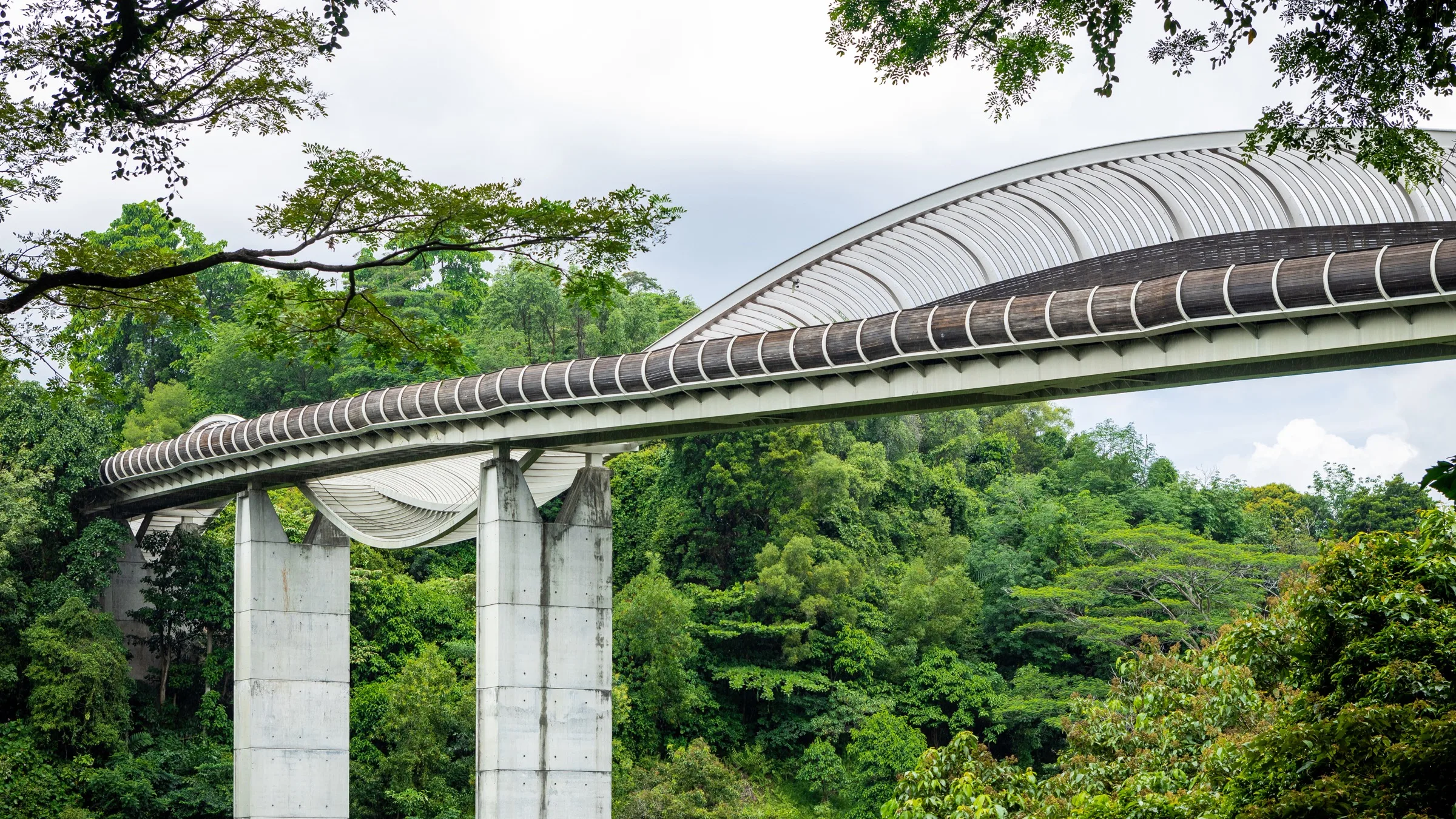
Henderson Waves is the reason the two hills are one walk. NParks describes a 274-metre pedestrian bridge with a wave-like timber deck, the tallest pedestrian bridge in Singapore, built so people could move between the nature areas of the Southern Ridges. Seven undulating ribs form alcoves and give some shelter. At the Mount Faber Plaza end, a nutmeg tree marks the hill’s earlier life as a nutmeg plantation. The board asks visitors to come in the morning, when it is cooler, or after dark for the LED lighting, which runs from 7pm to 2am. An older brochure said the lights ran until 7am. The current feature page is the one to follow, and it can change.
The photograph shows the bridge from the side: the rising timber wave, the concrete piers, and the forest underneath. It was taken on 18 January 2020. The camera position is about 115 metres from the deck point used on this map, so the picture is of the structure, not a view from standing on it. The chapter point itself is on the mapped bridge deck.
You do not reach that deck by assuming the old footpath is open. The Mount Faber Loop closure, in force since 14 January 2025, is specifically the link between Henderson Waves and Mount Faber Peak. NParks publishes two alternatives, one with stairs and one without. This page does not draw either of them, because the notice map is a picture rather than a surveyed line this site can check against the road network. On the ground, use the signed route. The bridge deck is a different surface from Marang Trail. The older brochure calls the bridge wheelchair-friendly. The current pages for both parks still say there is no wheelchair access to the parks themselves, and Marang Trail is a staircase. A step-free alternative on one link is not a step-free day.
The west end of the bridge is already Telok Blangah Hill Park. The next chapter stays on that hill. It does not continue the scenic 10-kilometre ridge.
Real-travel note
The bridge is 274 metres and lit from 7pm to 2am. Come earlier in the day if you want cooler air. The footpath from Mount Faber Peak is still on the closure notice; follow the signed alternative. Please recheck lighting and access before you go.
Chapter 4 · Stop on the next hill
Terrace Garden
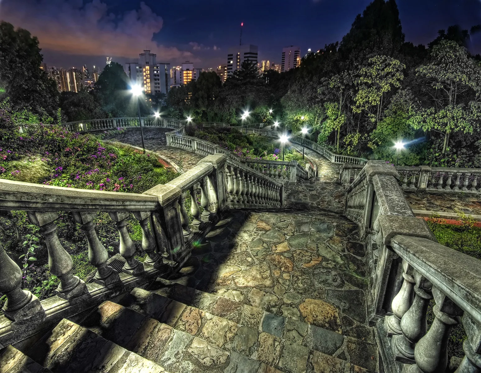
Terrace Garden is where this edition ends. NParks describes a series of semi-circular terraces on the hilltop, with a wide view over Singapore, and notes that wedding parties use it. Telok Blangah Hill Park covers about 34 hectares off Henderson Road, at Telok Blangah Green. It is open 24 hours, except the Earth Trail, which should not be entered after 7pm. There is no wheelchair access to the park. OpenStreetMap records a nearby hill point at 94 metres, below the 106 metres mapped at Faber Point. The drop is real, but it is not a surveyed height difference for your walk.
The photograph was taken at night on 2 January 2010. Stone balustrades turn with the terraces, and the city lights sit beyond the trees. The file has no camera coordinates. The match is the subject: those curved terraces are what the park page describes. The picture is also heavily processed, with bright starbursts around the lamps. It is a photograph of the place, not a neutral daylight record, and it has not been enlarged for this site. The original is 1,547 pixels wide.
Getting here from the bridge is a short hill walk, not a continuation of the whole ridge. The map shows one OpenStreetMap pedestrian route from the bridge deck to the garden, reviewed on 24 September 2026. The routing uses Telok Blangah Green, the road along the north side of the hill. That matters because a footpath below the Therapeutic Garden has been closed for slope works since 13 June 2025, with 31 March 2028 as the expected completion. The notice draws an alternative in orange. Do not leave the signed paths to cut across the repair area. This line is an editorial reference, not a guarantee that it is the orange path in every metre.
Two further limits belong in the same sentence. Parts of Forest Walk, the elevated trail that continues west toward Alexandra Arch, are unlit between 7pm and 7am during maintenance expected to finish on 30 September 2026. And the Alexandra–Queensway park connector, farther along the Southern Ridges Loop, remains closed until the third quarter of 2027. This walk does not enter either of those sections. Leave from Telok Blangah Green and recheck buses. The 10-kilometre ridge is a different day, and only after the notices say so.
Real-travel note
This is the last stop. A footpath below the Therapeutic Garden is closed until an expected 31 March 2028. Forest Walk lighting works and the Alexandra–Queensway closure are farther west and are not part of this walk. Please recheck NParks before you travel.
Sources
- Labrador Nature Park Network and the Southern Ridges — National Parks Board
- Mount Faber Park — National Parks Board
- Telok Blangah Hill Park — National Parks Board
- Henderson Waves — National Parks Board
- Mount Faber Loop footpath closure — National Parks Board
- Telok Blangah Hill Park footpath closure — National Parks Board
- Park connector notices — National Parks Board
- Your Guide to the Southern Ridges — National Parks Board
- Marang Trail steps — OpenStreetMap
- Mount Faber summit and Faber Point — OpenStreetMap
- Henderson Waves Bridge — OpenStreetMap
- Terrace Garden — OpenStreetMap
- Marang Trail, 4 December 2024 — Wikimedia Commons
- Views of Faber Point, 4 December 2024 — Wikimedia Commons
- Henderson Wave Bridge (I) — Wikimedia Commons
- Terrace Garden, Telok Blangah Hill Park — Wikimedia Commons
.jpg)
.jpg)
.jpg)

Your journey, remembered.
The keepsake unlocks when you reach this section.