
Paris: an island, two banks and different ways to arrive
Explore Paris from Hôtel de Ville to Notre-Dame, Sainte-Chapelle, Pont Neuf and the Louvre’s historic exterior. Fifteen photographs and optional local 360° scenes compare civic space, a cathedral, a royal chapel and the river; four extra discoveries reward a slower look.
Begin the visual journeyPlan a real visit to Paris Île de la Cité & SeineExplore 9 reviewed views along the routeGuided visual journey
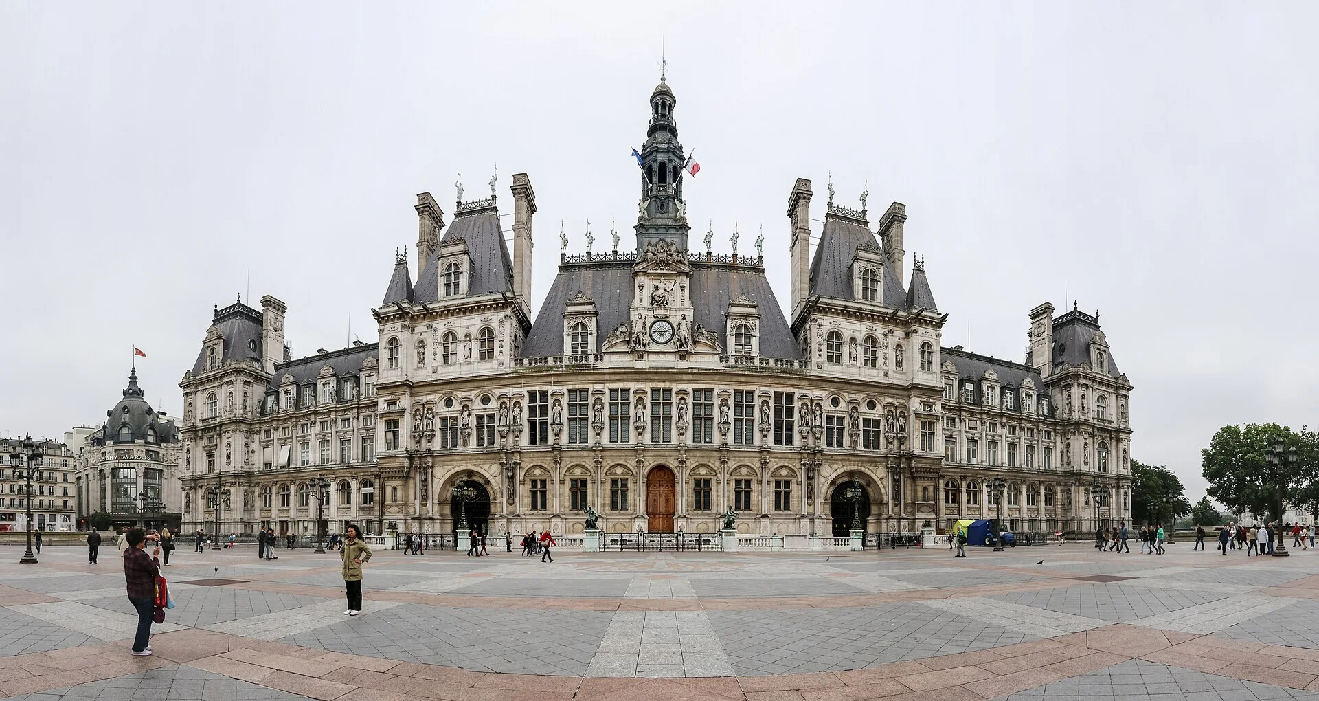
Hôtel de Ville and its square · Dietmar Rabich · CC BY-SA 4.0 · Resized and converted to WebP
Reading mode
Place stories to read at your own pace
Use the arrows and thumbnails to compare the wider setting, a closer view and a detail. These are separate dated photographs.
Chapter 1 · A public face
Read the city hall across its open square
Begin with the space in front of Hôtel de Ville. The broad square makes the building legible as a whole: repeated windows, projecting roofs and a central clock can all be held in one view. Then notice how quickly people become small against that arrangement. The square is part of the encounter, giving a civic building enough foreground to address a crowd rather than only the person at its door.
The July 2014 photograph establishes that broad relationship. Two July 2012 pictures bring the scale down to a gateway and the façade’s statue of Molière. The city’s own history records the destructive fire of 1871 and the later rebuilding. A familiar-looking historic façade therefore needs to be read as a reconstructed civic statement, not as a surface untouched by the events it represents. The statue photograph adds another question: which people are placed on a public building, and how high above everyday sight do they stand?
The optional May 2014 scene offers a few local exterior positions and a return. Rotate towards the building, then towards the square to compare the two scales. It does not enter the municipal offices or establish today’s event arrangements. Tour Saint-Jacques is a separate nearby discovery, where a surviving tower has a different relationship with its surrounding garden. The journey then changes banks and buildings through an editorial transition, not a surveyed street crossing.
Real-travel note
May 2014 exterior square-area imagery. Municipal rooms, events and a crossing towards the island are separate arrangements.
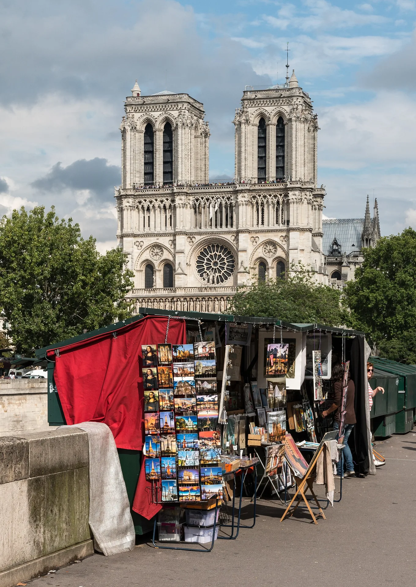
Compare the 2014 riverside frame, September 2025 front and a pre-fire sculptural detail. These are different positions and dates, not a construction survey.
Chapter 2 · A façade across time
Compare Notre-Dame before the fire and after reopening
Notre-Dame becomes more interesting when the frame includes where you are standing. In the July 2014 photograph, a riverside bookstall and trees occupy the foreground while the twin towers rise beyond. The September 2025 image moves closer to the west front. These pictures are separated by both distance and history; their difference should not be flattened into a simple before-and-after construction diagram.
The close sculptural photograph returns to July 2014. Compare a carved figure’s scale with the towers in the wider images, then consider what neither picture can tell you: the state of every interior surface, the sound of worship or the arrangement of today’s queue. The cathedral reopened in December 2024. Its official visitor page describes free cathedral admission and an optional free reservation, but other experiences such as the towers have separate arrangements. This outdoor chapter does not include any of them.
The April 2014 Google scene is deliberately identified as pre-fire imagery. It gives a historic view from the parvis area with three local positions and a return; it is not a present-day survey of the redesigned surroundings. Use the 2025 photograph to keep that time gap visible. Near the island’s northern side, the flower market offers a smaller, working environment. Its own independent scene does not create a continuous passage from the cathedral square or establish which stalls will be open.
Real-travel note
April 2014 panorama predates the 2019 fire. The gallery also includes September 2025; check current cathedral and separate tower arrangements.
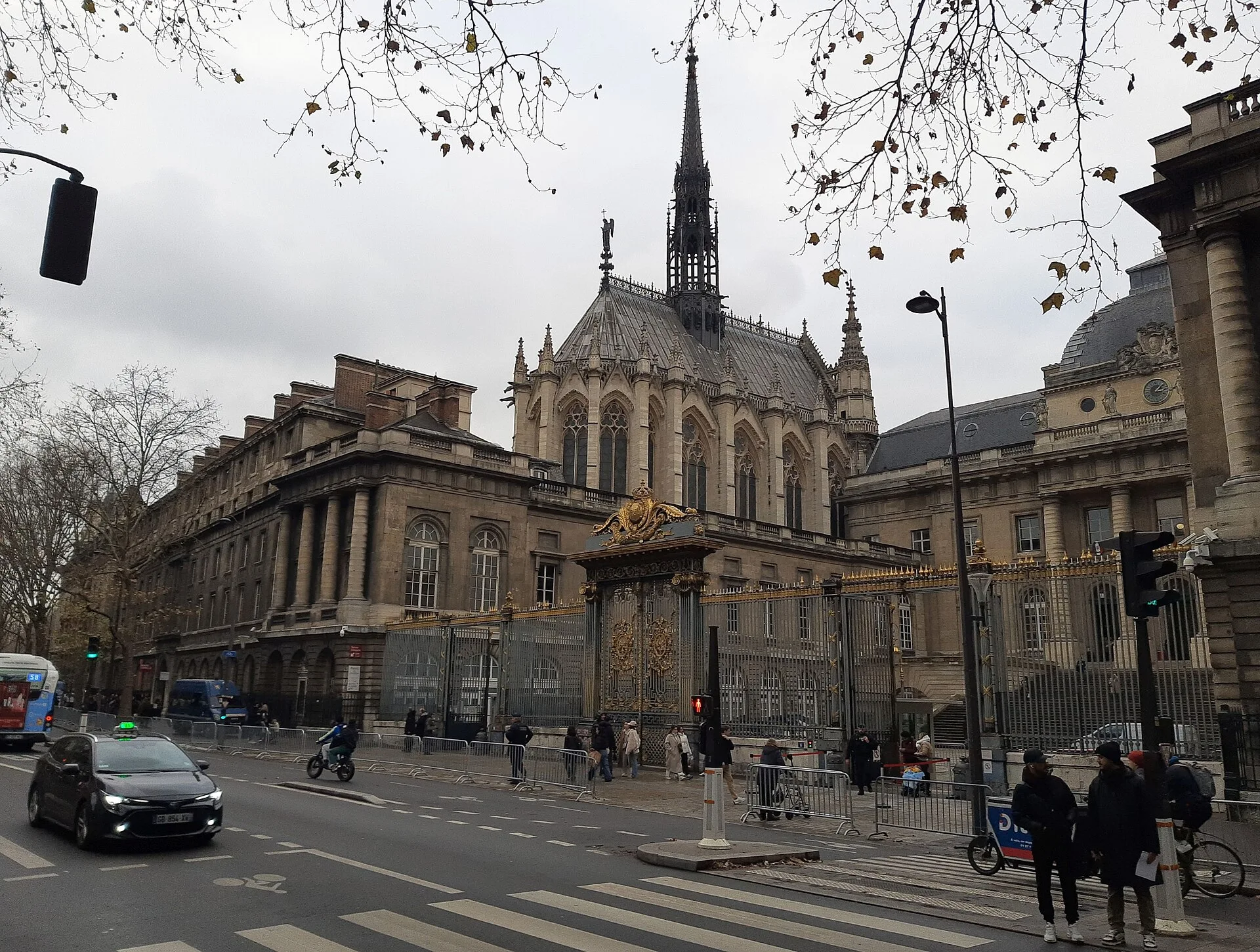
Use the arrows and thumbnails to compare the wider setting, a closer view and a detail. These are separate dated photographs.
Chapter 3 · A building behind another edge
Find Sainte-Chapelle above the palace precinct
Sainte-Chapelle is not presented to the street like the city hall. From outside, surrounding buildings and walls can break up its outline. Start with the December 2024 street photograph: find the narrow spire and the higher roof behind the nearer architecture. That partial visibility is useful. It reminds us that knowing a famous building’s name does not mean every public approach will offer a complete view of it.
The two February 2022 photographs move inside the surrounding precinct while remaining outside the chapel itself. They reveal more of the buttresses, windows and upper form. These are independent photographers’ positions, not proof that a visitor can walk through the same gate today. The monument’s own history connects the thirteenth-century chapel with Louis IX, the royal palace and the keeping of relics. Its celebrated glass is an indoor experience; this chapter studies how that building is approached and enclosed.
The optional July 2024 street-area fragment stays on the exterior approach. Turn to identify the precinct boundary before trying its three local positions and return. It does not pass security, enter the upper chapel or supply admission. Read the official visitor information before arranging an interior visit. Returning to the river at Pont Neuf then changes the kind of edge you are reading: from walls that limit a view to water that carries it much further.
Read further: Sainte-Chapelle: see the light before reading the glassReal-travel note
July 2024 exterior approach only. Precinct photographs were made from different positions; no security passage, chapel interior or admission is included.
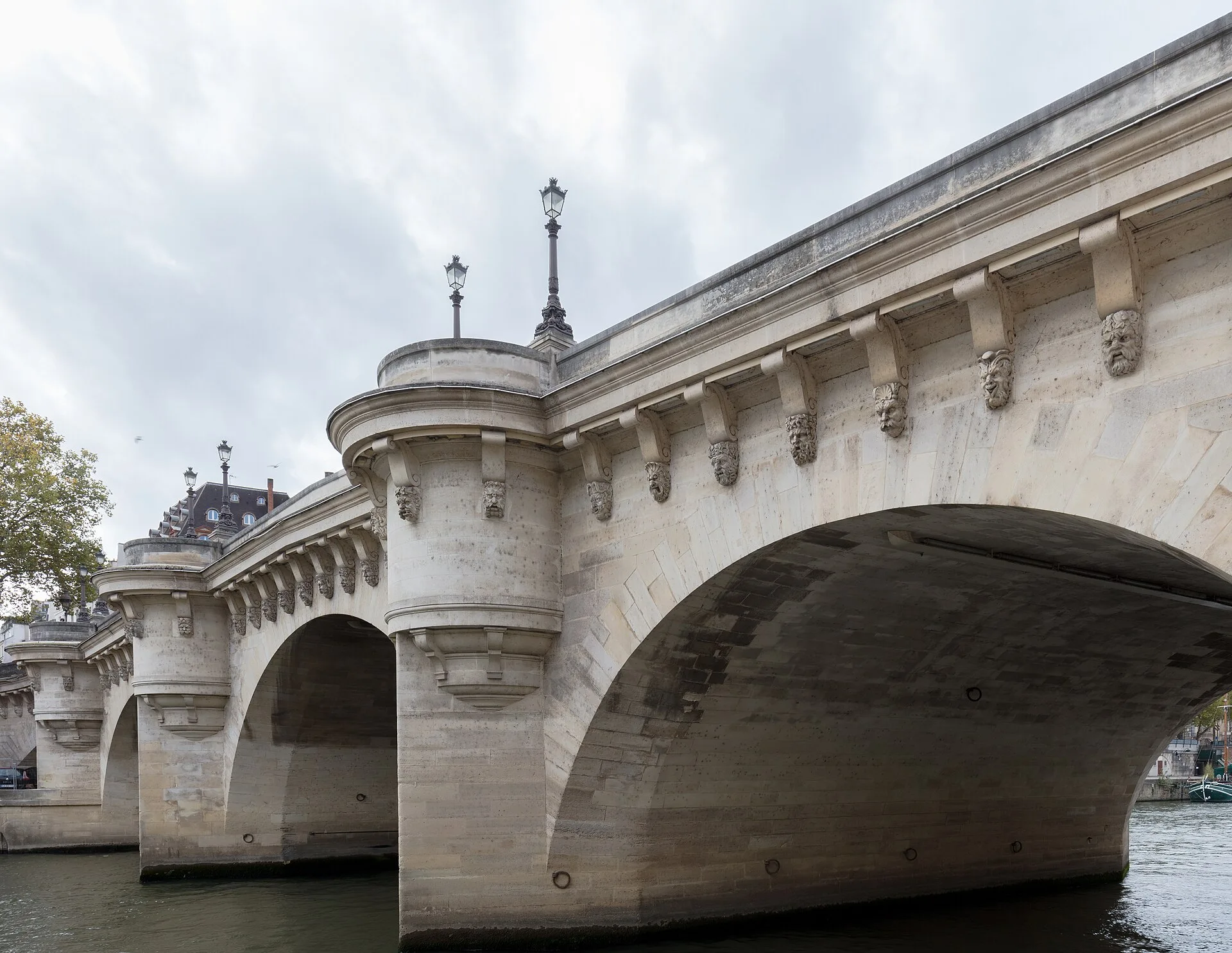
Use the arrows and thumbnails to compare the wider setting, a closer view and a detail. These are separate dated photographs.
Chapter 4 · Two banks in one view
Let Pont Neuf explain the island’s edge
At Pont Neuf, look beyond the idea of simply getting across. The bridge makes an island and two banks visible together. Follow an arch down towards the water, then trace the parapet back to street level. The river seems close in a photograph, yet the difference in height between the upper street and lower quays matters to a real visit. A visible path below is not evidence of an open or step-free way down.
The November 2022 photograph brings the bridge’s stone structure close; the July 2014 bridge-edge view and broader river photograph add trees, boats and a longer horizon. Compare the solidity of an arch with the changing surface beneath it. The city describes Pont Neuf as Paris’s oldest bridge despite its name. That apparent contradiction makes a useful starting question, but there is more to notice than an age ranking: small projecting spaces, the rhythm of the supports and the way the island interrupts the crossing.
The June 2024 optional scene offers three locally checked positions and a return, without surveying the full bridge or connecting from the chapel. The Vert-Galant discovery considers the lower garden from a different camera context and an independent river-facing photograph. Water levels, gates and steps need current information. After that, the Louvre’s palace frontage offers another kind of horizontal rhythm, turning the journey from arches over water to columns beside an urban square.
Real-travel note
June 2024 local bridge-area imagery. No complete crossing, lower-quay access or step-free descent is verified.
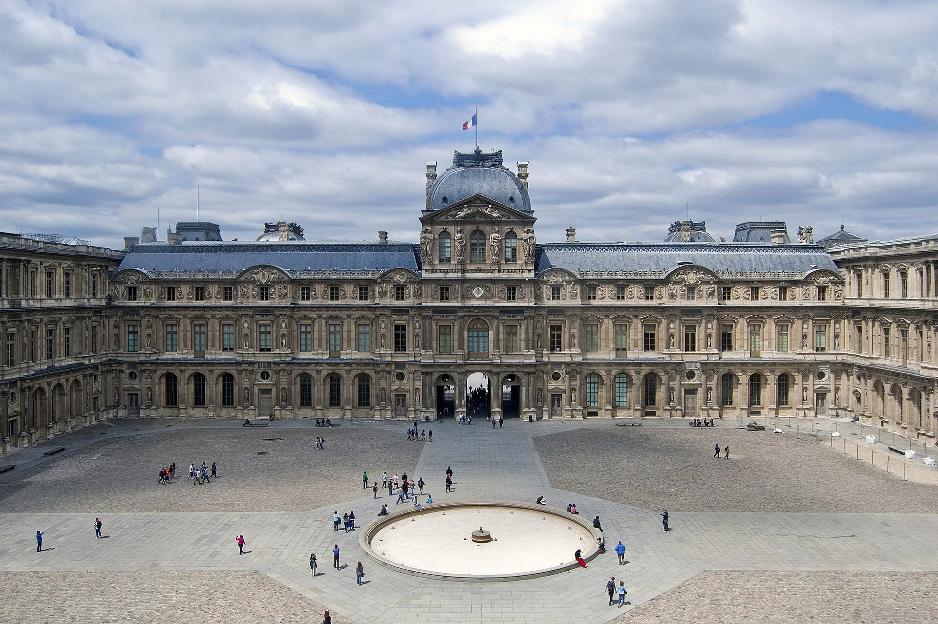
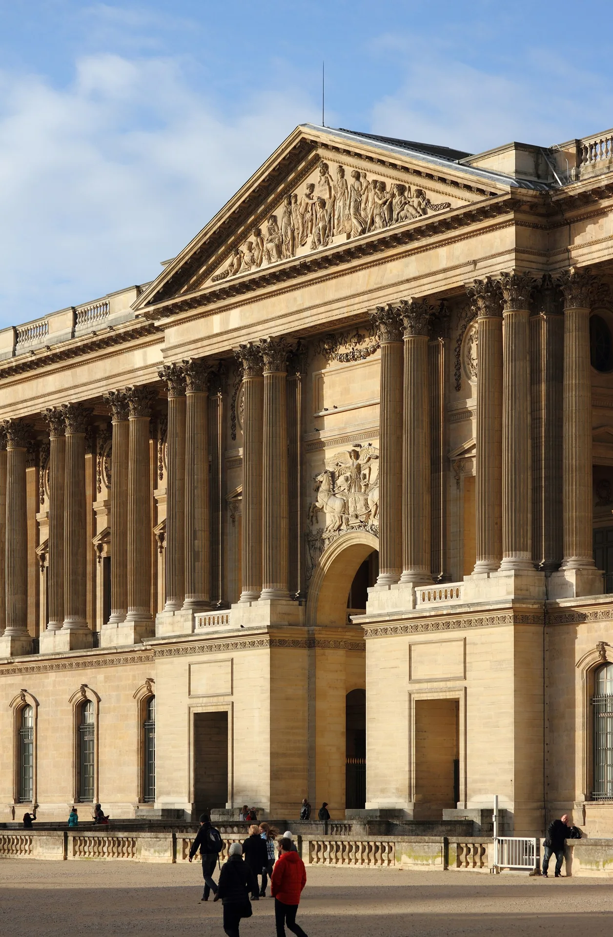
Compare an elevated courtyard view, a niche figure and the exterior colonnade. Use the arrows and thumbnails.
Chapter 5 · The palace before the collection
Read the Louvre through a courtyard, a figure and a colonnade
End with the Louvre as a building in the city, before deciding what to see in its galleries. The photographs concentrate on the historic palace rather than promising an entire museum visit. The broad Cour Carrée photograph was made from an elevated position: it shows how a courtyard can organise several wings at once, but it is not the view of somebody standing on the paving.
The June 2010 courtyard image, May 2012 niche statue and December 2012 eastern colonnade belong to different observations. Compare a single sculpted body with the repeated vertical lines of the columns. Then return to the elevated view and notice how windows and roofs repeat around the empty centre. The statue is part of a façade, not an artwork encountered inside a gallery. These changes of scale give the palace depth without inventing an indoor walk from exterior photographs.
The November 2022 Google fragment is near the eastern façade, outside the museum. Rotate towards the colonnade and compare the three local positions, then return. It does not enter Cour Carrée from the street, cross the security perimeter or carry you to the Pyramid. Pont des Arts is a separate river discovery, linking the palace’s urban setting with another long view of the Seine. For a museum visit, consult the Louvre’s current admission and access information. The online journey can finish here with a remembered relationship between water, open ground and a monumental façade.
Read further: The Louvre: look at the building before the paintingsReal-travel note
November 2022 eastern-façade exterior fragment. The courtyard photograph is elevated; no courtyard connection, museum interior or ticket is supplied.
9 reviewed experiences
Explore along the route
Step into the places along this journey. Choose a view independently of the story chapters. Free previews do not count toward chapter progress. Return to the journey above to continue through its stops.
Read the city hall across its open square Short observation sequence
May 2014: three local exterior positions around the city hall square and return. Rotate towards the civic façade; no office interior, event timetable or continuous crossing to the island.
Reviewed 2026-10-26 · Nearby viewpoint
Explore at your own pace; these views do not count toward chapter completion. Check each point's coverage note before navigating provider imagery. Availability may change.
Sources
- The history of the Hôtel de Ville in seven dates — City of Paris
- All about Paris City Hall — City of Paris
- Notre-Dame: free admission and reservations — Notre-Dame de Paris
- Reopening of Notre-Dame de Paris — Paris je t’aime
- A unique set of stained-glass windows — Centre des monuments nationaux
- History of Sainte-Chapelle — Centre des monuments nationaux
- Sainte-Chapelle visitor information — Centre des monuments nationaux
- Pont Neuf: the oldest bridge and a refuge for birds — City of Paris
- The Louvre palace — Musée du Louvre
- Visit the Louvre — Musée du Louvre
- Tour Saint-Jacques — City of Paris
- Marché aux fleurs Reine Elizabeth II — City of Paris
- Square du Vert-Galant — City of Paris
- Pont des Arts — City of Paris
- Santa Capilla, París, Francia, 2022-11-01, DD 80-82 HDR.jpg — Diego Delso, delso.photo · Wikimedia Commons
- Paris, Hôtel de Ville -- 2014 -- 1720-5 - 2.jpg — Dietmar Rabich · Wikimedia Commons
- Hôtel de Ville de Paris détail façade.jpg — Jebulon · Wikimedia Commons
- Molière Hôtel de Ville Paris.jpg — Jebulon · Wikimedia Commons
- Paris, Notre Dame -- 2014 -- 1437.jpg — Dietmar Rabich · Wikimedia Commons
- Notre Dame west facade 2025-09-02 - 01.jpg — The wub · Wikimedia Commons
- Paris, Notre Dame -- 2014 -- 1477.jpg — Dietmar Rabich · Wikimedia Commons
- Sainte-Chapelle, Paris, from street.jpg — Gerda Arendt · Wikimedia Commons
- Paris, Sainte-Chapelle, Außenansicht (4).jpg — Cmcmcm1 · Wikimedia Commons
- Paris, Sainte-Chapelle, Außenansicht (3).jpg — Cmcmcm1 · Wikimedia Commons
- Puente Nuevo, París, Francia, 2022-11-01, DD 39.jpg — Diego Delso · Wikimedia Commons
- Paris, Pont Neuf -- 2014 -- 1425.jpg — Dietmar Rabich · Wikimedia Commons
- Paris, Seine -- 2014 -- 1321.jpg — Dietmar Rabich · Wikimedia Commons
- Louvre Cour Carrée June 2010.jpg — King of Hearts · Wikimedia Commons
- Statue Cour carrée Louvre 1.jpg — Jebulon · Wikimedia Commons
- Colonnade du Louvre.JPG — Caroline Léna Becker · Wikimedia Commons
- Tour Saint-Jacques, Paris.jpg — Wilfredor · Wikimedia Commons
- Marché aux fleurs Reine-Elizabeth-II, Paris 13 August 2013.jpg — Shadowgate from Novara, ITALY · Wikimedia Commons
- Square du Vert-Galant seen from the Seine.jpg — DiscoA340 · Wikimedia Commons
- Pont Arts - Paris VI (FR75) - 2024-05-23 - 1.jpg — Chabe01 · Wikimedia Commons


Your journey, remembered.
Explored 0 of 5 stops. Explore every stop to unlock your keepsake.
5 stops to your keepsakeExplore every stop to share or download your keepsake.
Plan time beside the Seine
Use the chapters to choose places, then arrange real connections and admission separately.
Official sources checked:
Keep river levels in the plan
The chapter order is editorial, not a measured walking track. Allow half a day outdoors as a planning estimate, with extra time for detours and interiors. Upper roads, bridges and lower quays are different levels; check gates, steps and current river conditions.
Three institutions, separate arrangements
Notre-Dame’s cathedral admission, its towers, Sainte-Chapelle and the Louvre do not share one booking arrangement. Use the official institution pages; an exterior panorama or precinct photograph supplies no admission.
Do not use archival scenes as current access checks
The cathedral panorama predates the 2019 fire, while a gallery photograph dates from September 2025. Expect further changes around the buildings and recheck current entrances, works and closures.