
Hoi An Ancient Town: from the Japanese bridge to the Thu Bon bank
Follow this Hoi An Ancient Town walking route from the Japanese Covered Bridge, along a merchant house and the Fujian hall, to the market and the Thu Bon riverbank.
Guided visual journey
Reading mode
Place stories to read at your own pace
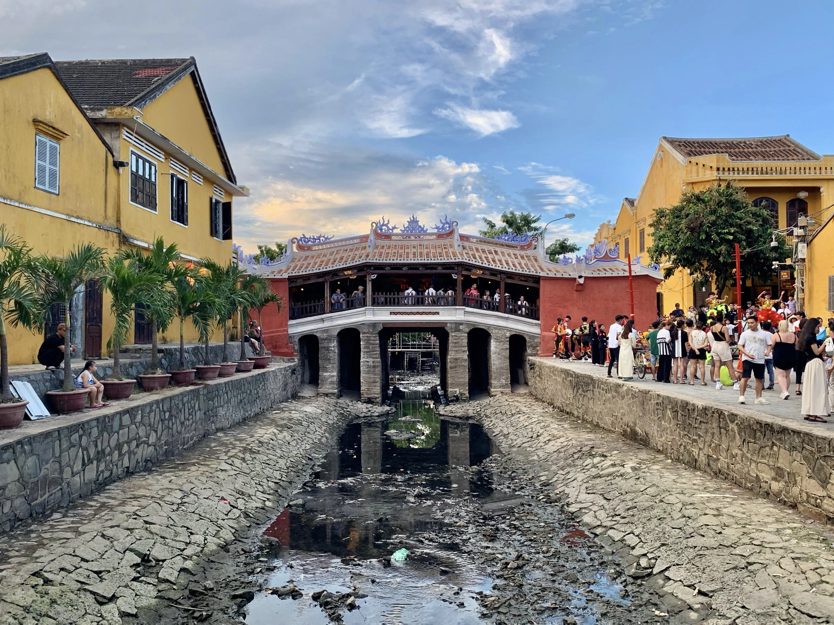
Chapter 1 · The creek, not the river
The Japanese bridge from the south bank
Begin at the east end of the covered bridge, where Trần Phú starts. The bridge is a short wooden span with a tiled roof and pink abutments. It crosses a creek. The Thu Bon, the river that made the port, is still to the south. Cars are not the point here. The bridge itself is a footway.
The photograph looks north at that creek face. On 1 August 2024, at 17:36, the camera stood about 40 metres south of this spot. The creek bed in the frame is low and muddy, with the stone arches and the tiled roof above it. That is one afternoon. It is not the water level you will meet. The file title says the picture is after renovation. The heritage centre’s monument page does not itemise that work, so this is the August 2024 exterior, not a list of what was replaced.
Two official accounts of the date sit side by side, and they are not the same sentence. UNESCO’s brief synthesis calls it a fine wooden Japanese bridge, with a pagoda on it, dating from the 18th century. The Hoi An heritage centre’s page quotes an 1817 stele still kept at the bridge. The stele says, as tradition, that Japanese people built it. From that tradition the centre infers an early-17th-century origin, and says the structure you see was rebuilt in the 18th and 19th centuries by Hoa and Vietnamese residents after repeated repairs. The name Lai Viễn Kiều was given in 1719 by Lord Nguyễn Phúc Chu. A further tradition on the same page says the bridge was meant to pin a water monster whose head lay in India, whose back lay in Hoi An and whose tail lay in Japan. That story is marked as tradition. It is not a construction record.
The small temple on the bridge, to Bắc Đế Trấn Võ, is why the local name is Chùa Cầu, “bridge pagoda.” The January 2026 heritage notice asks visitors to buy a ticket before entering the ancient town. The prices it prints include the general landscape plus a monument choice, and the bridge interior is one of those named choices. The notice does not mark this street end as free of that ticket. This walk stays at the east end. From here the checked pedestrian line goes a couple of metres east on Trần Phú, then south beside the creek onto Bạch Đằng, and only then east onto Nguyễn Thái Học. The next door is a merchant house, not another bridge.
Real-travel note
The January 2026 notice asks visitors to buy a ticket before entering the ancient town, and it names the bridge interior as a monument on that ticket. It does not define a free stretch of these streets. Recheck the ticket and the walking hours before you go on, and again before you step onto the bridge.
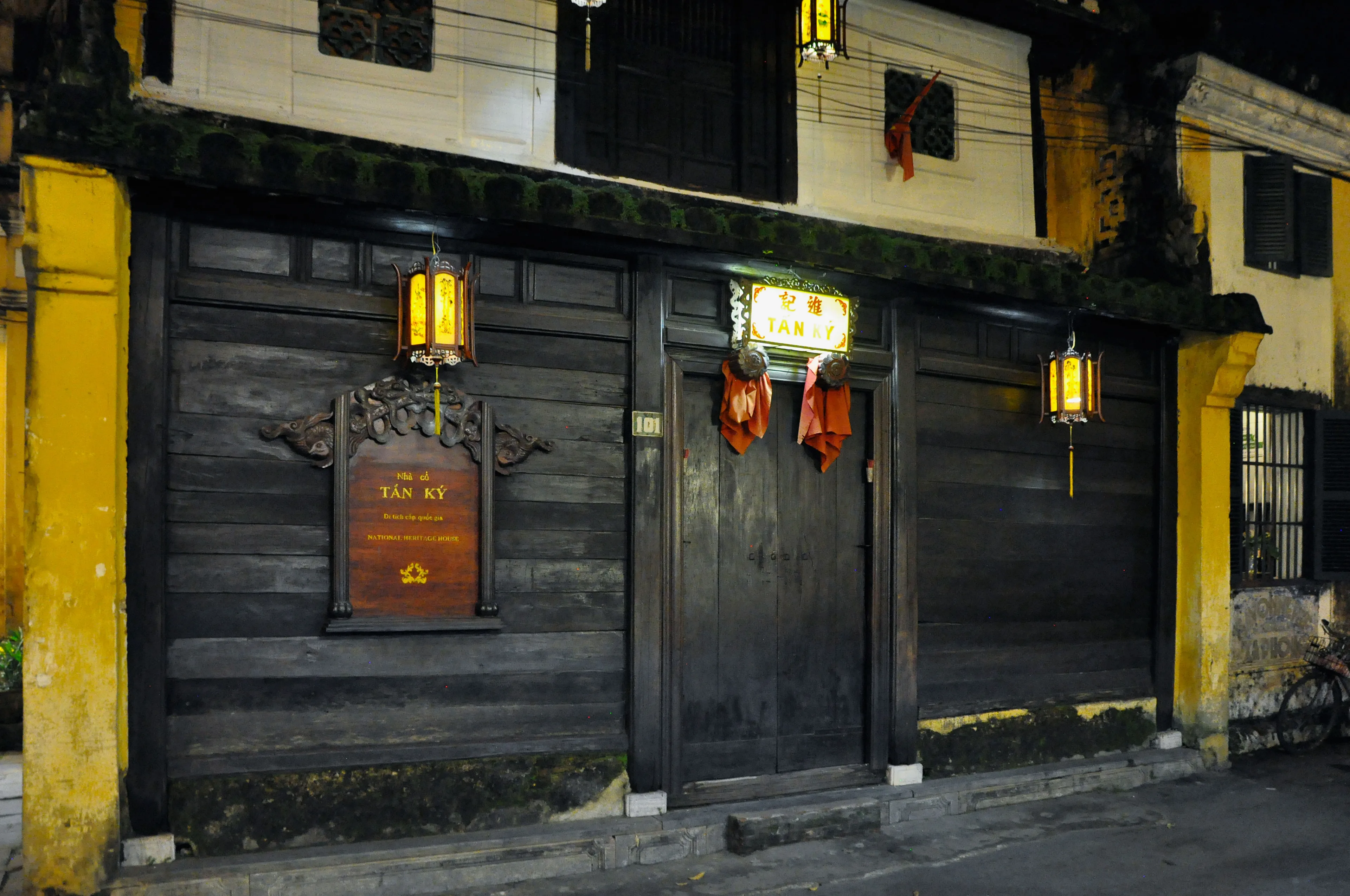
Chapter 2 · A shop that is also a house
Tan Ky House, number 101
Nguyễn Thái Học brings you to a dark timber front. The door is numbered 101. A sign reads Tấn Ký. This is the street face of a merchant house, not a view through to the river. The mapped building sits immediately south of the roadway, between this street and Bạch Đằng. UNESCO’s account of the town is this arrangement: buildings front the street for customers, and the backs open toward the river so boats could load and unload. You are on the customer side.
The photograph is that door at night in 2015. The file has no GPS. The number 101 and the Tấn Ký sign are what tie it to this address. The shutters are closed. Daytime, if the house is open to visitors, the door will not look like this. The interior is a separate, ticketed visit. This chapter does not use an altar or a courtyard as the street.
The heritage centre’s page on the house says the shop name is Tấn Ký, that the house was built in the 19th century, and that it received national historic ranking in 1990. It describes a two-storey house with a porch and the timber floor used in Hoi An. The January 2026 ticket notice does not print this house’s name in its coupon list. It speaks of a set number of self-selected monuments “in the rest,” and it also asks visitors to buy before entering the ancient town. That request is not the same sentence as a coupon for this doorway. Ask at the booth which stub, if any, this door takes, and do not assume the street in front is outside the town ticket. Do not treat a blog’s memory of the list as the notice.
When you leave, stay on Nguyễn Thái Học and walk east. The next turn is north, on Hoàng Văn Thụ, up to Trần Phú. The assembly hall is on that upper street. The river is still one street south, and you meet it again only after the market.
Real-travel note
This chapter follows the street in front of the house. The January 2026 notice asks visitors to buy before entering the ancient town and does not say this frontage is exempt. The interior is a separate visit, and the notice does not name it in the coupon sentences. Recheck before you go in.
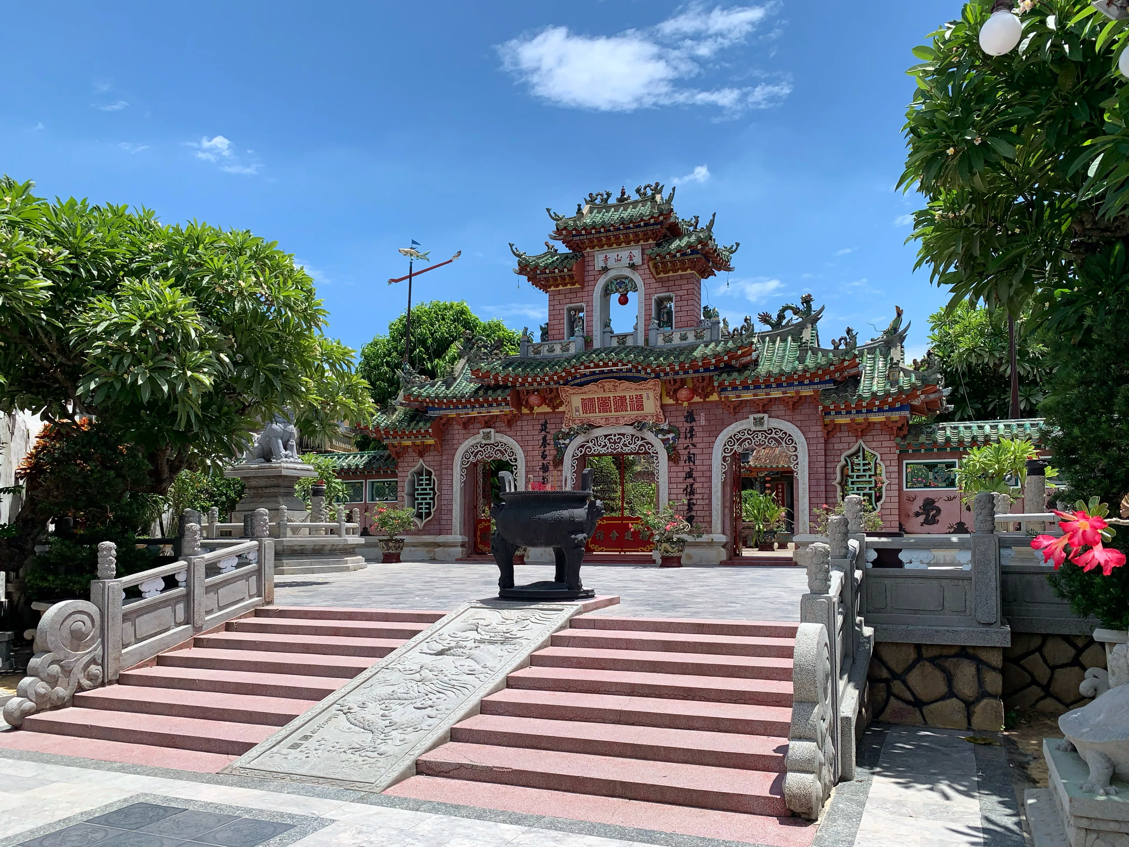
Chapter 3 · A congregation, off the street
The Fujian hall, from the courtyard
Hoàng Văn Thụ brings you up from the merchant street to Trần Phú. Number 46 is the Fujian assembly hall. The heritage centre says it was built in 1697 as the meeting place and temple of the Fujian community in Hoi An, and that the main gate is on Trần Phú. Inside, the hall is dedicated to Thiên Hậu and to deities linked with waterways, wealth and children. The same page says the compound keeps evidence of the port’s foreign trade, and that the hall was ranked a national monument in 1990.
The photograph is not the gate and not the pavement. On 2 August 2024, at 10:58, the camera stood inside the courtyard, about 20 metres north of the Trần Phú carriageway and about 40 metres from this mapped point, looking at the hall. The walk’s point stays on the street. The line drawn on the map does not enter the court. If you go in, you leave the walk for a ticketed visit and come back out to Trần Phú before continuing.
The January 2026 notice does not name this hall in the sentences that list coupons. It allows a set of self-selected monuments besides the Japanese bridge or Quan Công Temple. Confirm at the gate which stub this hall takes. Dress as you would for a working place of worship. The people in a courtyard are not scenery.
The market is not a separate district. Its north gable is the next building east along this same street, about 17 metres by the pedestrian router. You can see the yellow roof before you have finished passing the hall.
Real-travel note
The street point is the gate front. The photograph is the courtyard. Recheck the coupon and any dress notice before you enter. The market gable is the next roof east.
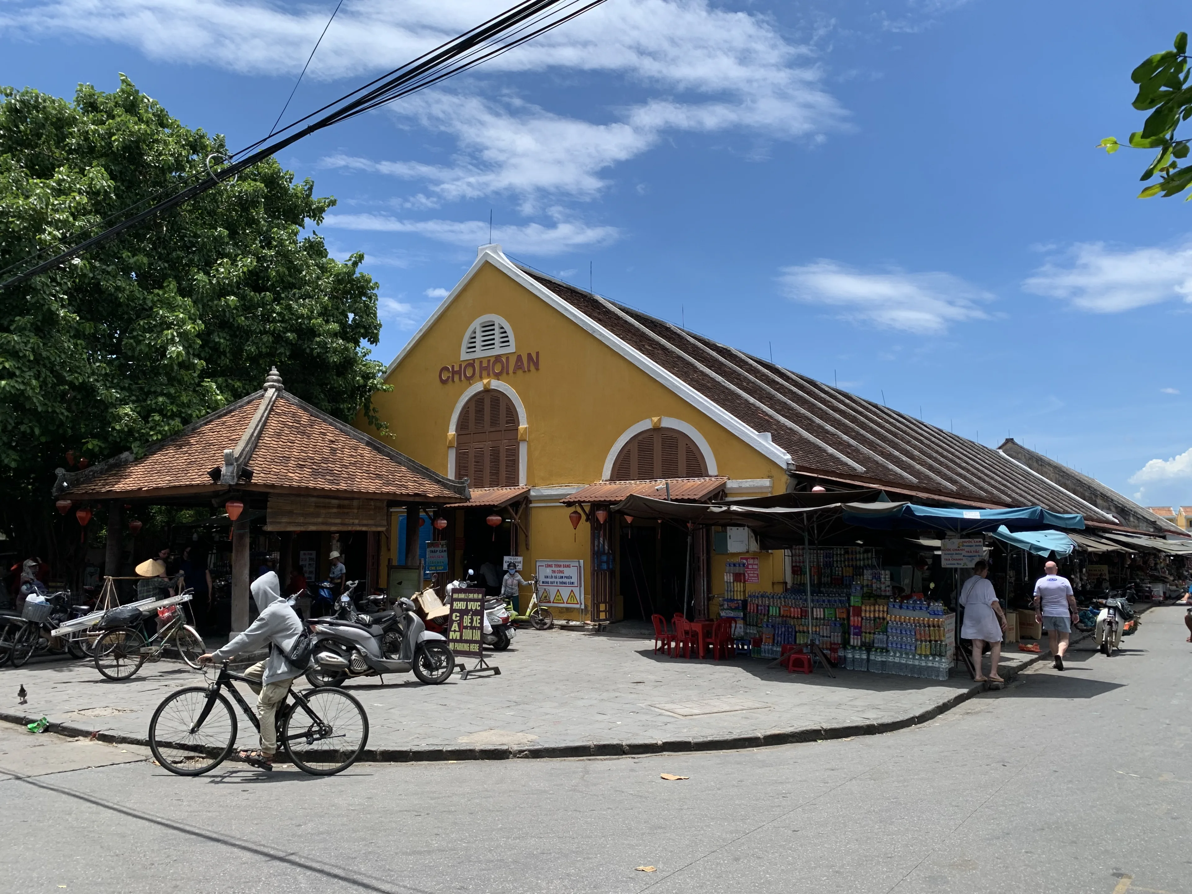
Chapter 4 · Trade that is still work
The market gable on Trần Phú
A few steps east of the hall, the street meets a long yellow hall. The gable reads CHỢ HỘI AN. This is the market’s north end, on Trần Phú. OpenStreetMap draws the building from this street south to Bạch Đằng, so the same roof covers the block between the upper street and the quay. You are not yet at the water. You are at the end where the town’s through-street and the market share a corner.
The photograph is that gable at 11:11 on 2 August 2024. The camera’s GPS is this corner. Motorbikes, a bicycle and people at the stalls are in the frame. The heritage notice asks visitors to follow the walking-and-cycling rules in the ancient town from 9:00am, so a picture with motorbikes is that August morning, not proof of what the street allows at every hour. The people selling and sitting here are at work. Leave them room. A person at a stall is not part of the view.
No official timetable for this hall was on the visit notice read on 27 September 2026. Do not borrow the opening hours tagged on the separate cloth market farther east. If a particular hour matters, look at the door when you arrive.
The way on from here is south, not deeper into the stalls. Trần Quý Cáp runs down the market’s west side to Bạch Đằng. That is the river street. The mapped line uses it. It does not draw a path through the aisles.
Real-travel note
This is a workplace. The photograph is 11:11 on 2 August 2024, with motorbikes still in the frame. Recheck the day’s vehicle rules and leave people room to work.
Chapter 5 · The port’s edge
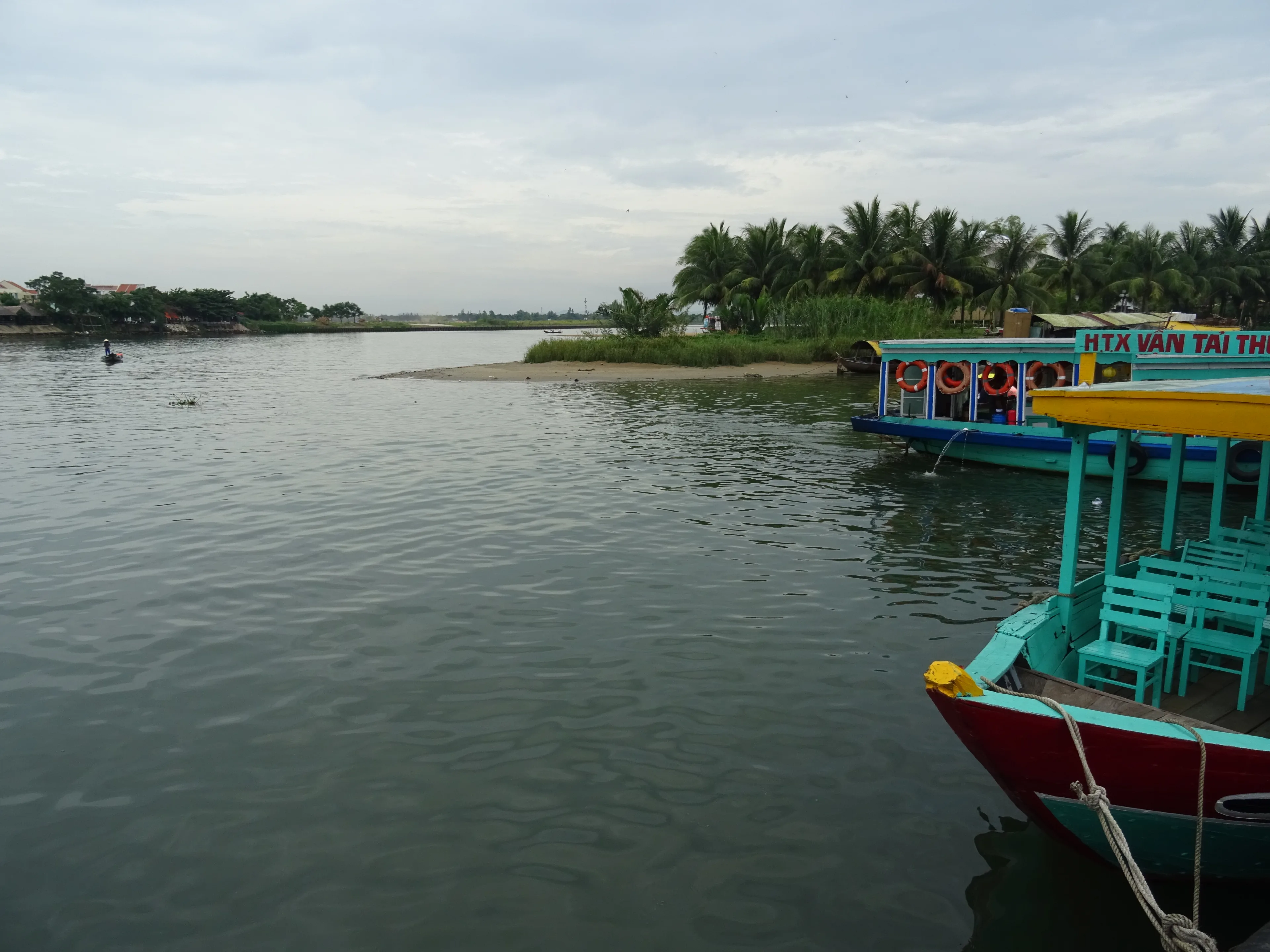
The Thu Bon, from Bạch Đằng
Trần Quý Cáp drops you to Bạch Đằng, and the street turns west along the water. The town is now behind you. In front are passenger boats and the far bank of the Thu Bon. UNESCO places Hoi An on the north bank near the mouth of this river, and describes a street plan with one axis parallel to the water. This is that axis. The bridge you started from crosses a creek. This is the river the creek runs toward.
The photograph was taken at 15:53 on 26 July 2018. The camera stood at the water’s edge, about 8 metres south of the mapped centre of Bạch Đằng. You see boats and the opposite shore. You do not see the market gable. A dry edge in a July picture is one afternoon. It is not a reading of the rainy months, and it is not a flood notice.
The Vietnam National Authority of Tourism climate page describes Hội An as rainy, cool and cloudy from September to January, and warm to hot with sunny, clear skies from February to August. It says that from September tropical storms hit central Vietnam hard, and that from September to November the town sees a lot of rain and even a few small floods. Temperatures on that page are coldest in January. This is a seasonal sketch on a national climate page. It is not a forecast for the day you travel, and a 2018 photograph is not a live reading of the bank. Before you go, check the day’s official weather and any flood notice.
This journey stops on the bank. It does not board a boat and it does not cross to the south side. A boat in the picture is traffic on the water, not the path you walked. You have come from a creek bridge, past a merchant door, to a congregation hall, a market that is still a workplace, and the river those streets were built to serve. The ticket, the heat and the chance of floodwater are the decisions. The boats tell you the port is not only a museum.
Real-travel note
Stay on the bank. This walk does not cross. The photograph is 26 July 2018. Before you trust the edge, recheck the day’s official weather and any flood notice. The climate page is not that notice.
Sources
- Hoi An Ancient Town — UNESCO World Heritage Centre
- Announcement of the visiting in Hoi An Ancient Town — Hoi An World Cultural Heritage Conservation Center
- Chùa Cầu — Hoi An Center for Cultural Heritage Conservation
- Nhà cổ Tấn Ký, 101 Nguyễn Thái Học — Hoi An Center for Cultural Heritage Conservation
- Hội quán Phúc Kiến, 46 Trần Phú — Hoi An Center for Cultural Heritage Conservation
- Weather and climate in Vietnam — Vietnam National Authority of Tourism
- Chùa Cầu footway — OpenStreetMap
- Tan Ky House — OpenStreetMap
- Nguyễn Thái Học — OpenStreetMap
- Hội quán Phúc Kiến — OpenStreetMap
- Trần Phú — OpenStreetMap
- Chợ Hội An — OpenStreetMap
- Bạch Đằng — OpenStreetMap
- 2024 Hội An - Japanese Covered Bridge after renovation - img 11 — Wikimedia Commons
- Hoi An - Tan Ky Old House — Wikimedia Commons
- Hội An 2024 - Fujian Assembly Hall - img 01 — Wikimedia Commons
- Chợ Hội An - Hoi An Market (2024) - img 01 — Wikimedia Commons
- Thu Bon River in Hoi An 5 — Wikimedia Commons
%20after%20renovation%20-%20img%2011.jpg)

%20-%20img%2001.jpg)
%20-%20img%2001.jpg)

Your journey, remembered.
The keepsake unlocks when you reach this section.