
Copenhagen: from city squares to harbour and ramparts
Explore Copenhagen in five chapters, with fifteen switchable photographs and twelve checked interactive scenes. Compare Nyhavn’s waterfront, Amalienborg’s open square, a church interior and the green edges of Kastellet, without mistaking independent fragments for a continuous walk.
Begin the visual journeyPlan a real visit to Copenhagen Harbour & Royal QuarterExplore 12 reviewed views along the routeGuided visual journey
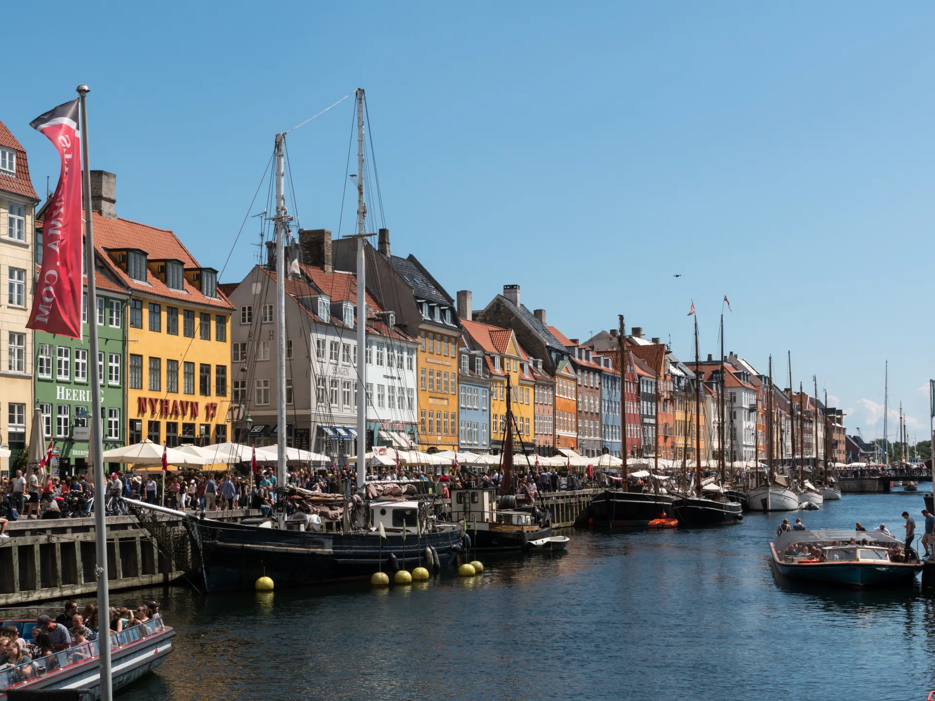
Colourful buildings and boats at Nyhavn · Dietmar Rabich · CC BY-SA 4.0 · Resized and converted to WebP
Reading mode
Place stories to read at your own pace
Compare the wider setting, a closer subject and a different view or date.
Chapter 1 · A city-sized room
Find your bearings around Kongens Nytorv
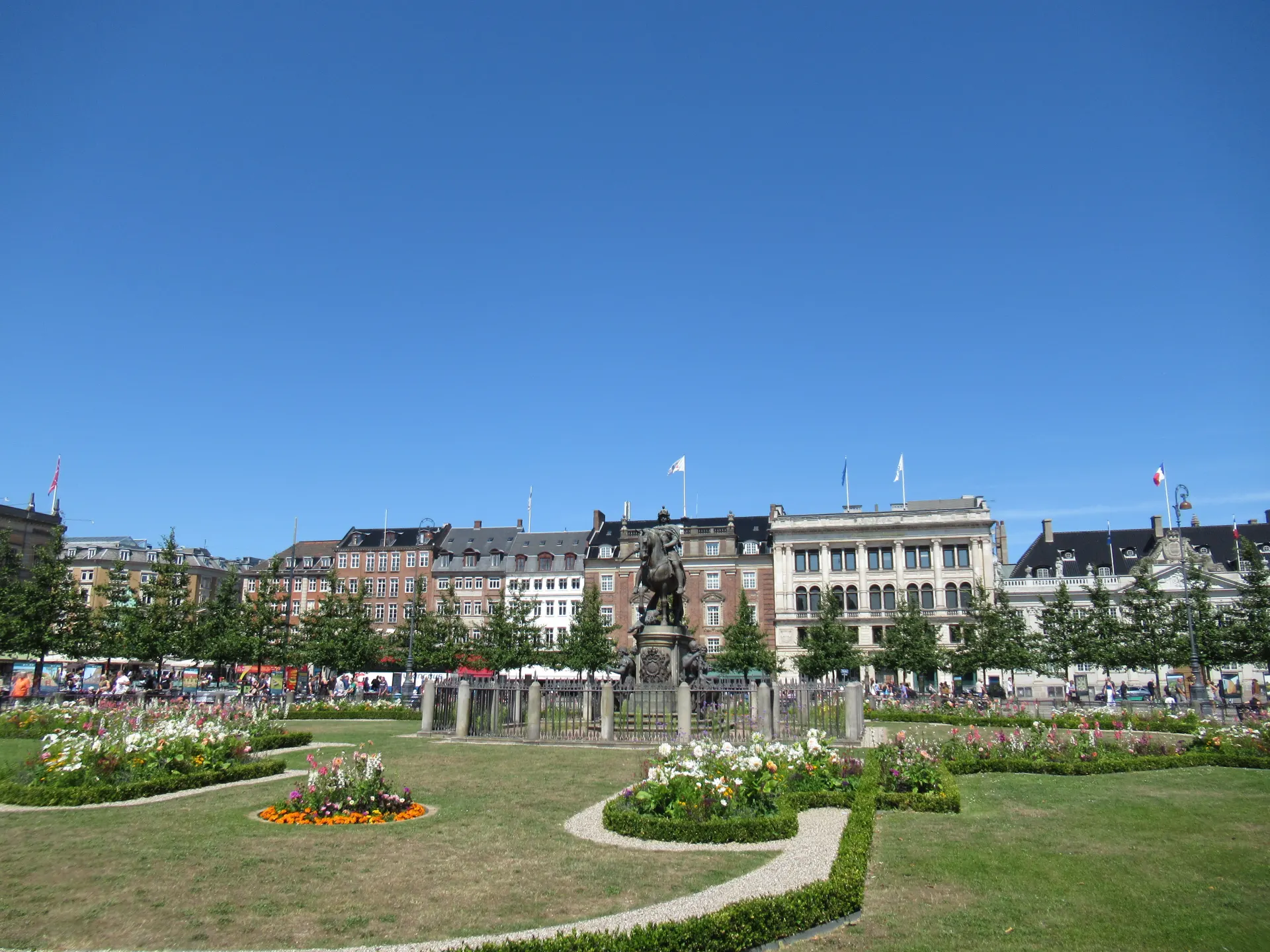
Begin by noticing the gap in the city rather than a single building. At Kongens Nytorv, façades hold a broad open space together, while roads, bicycles and pedestrians move around its edges. Find the trees, the line of the paving and the buildings across the square. They establish a useful contrast with Nyhavn’s much narrower strip of water in the next chapter.
The July 2023 square photograph gives an overall impression. An August 2022 view brings Magasin du Nord and a metro entrance into the foreground; a May 2023 photograph isolates Hotel d’Angleterre. Switch between them to compare scale and frontage. A building in a photograph is a landmark, not a restaurant or accommodation recommendation, and the separate dates do not describe one visit.
The July 2026 Google sequence begins on the square’s street edge near number 21. Its three positions and return let you compare the road, bicycle parking and tree-lined space, not walk through the whole square. The camera is in the carriageway: use it to look, not to decide where a person should stand. For a real visit, start from a safe pedestrian area and check crossings on a current map. The official tourism guide supplies the square’s wider architectural context, including the Royal Theatre and Charlottenborg; those buildings are not included interior stops here.
Real-travel note
Three July 2026 road-camera positions near the square, not an uninterrupted pedestrian crossing. Photographs record 2022–2023 conditions.
Compare the wider setting, a closer subject and a different view or date.
Chapter 2 · The narrow harbour
Read Nyhavn beyond the colourful postcard
Nyhavn compresses the scene into layers: water in front, moored boats across it, then a row of façades. Instead of trying to collect every colour, compare rooflines and the spaces between boats. The official harbour guide describes a museum-harbour setting in the inner part of Nyhavn. A vessel can be part of that setting without being available for boarding or included in this journey.
Two July 2017 photographs shift attention between the waterfront buildings and a closer ship view. The April 2018 evening photograph changes the light and the camera position. Look for the difference between a building’s colour and the impression created by shade or reflection. All three are independent licensed records, not frames of a recorded walk or a promise of evening illumination today.
The September 2024 interactive scene follows three linked positions on the south-side street near Nyhavn 16. Turn across the water for the opposite façades, move a short distance and return. Cars and quayside activity remain in the image; there is no virtual boat ride or verified connection to the palace. Along-route exploration offers a separate modern panorama at Ofelia Plads, where the harbour opens wider. If visiting in person, leave room beside moorings and restaurant terraces, keep away from unprotected water edges and use current pedestrian information for the onward connection.
Read further: Nyhavn: keep the water in the pictureReal-travel note
September 2024 south-side street fragment. No boat boarding, harbour cruise or continuous connection to Amalienborg is included.
Compare the wider setting, a closer subject and a different view or date.
Chapter 3 · An open palace square
Let Amalienborg’s façades surround you
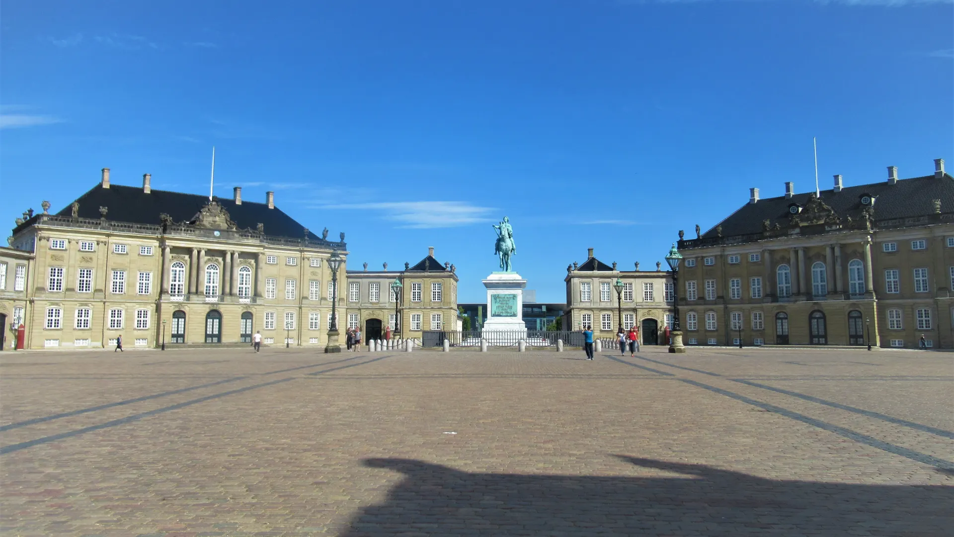
Amalienborg changes the spatial rhythm again. The harbour’s long edge gives way to an open square framed by palaces. Look at how the façades turn around you rather than searching for one front entrance. The official tourism guide describes four palaces around an octagonal space, with Frederik V’s equestrian statue in the centre. This is also a working royal setting, not an empty architectural stage.
The July 2018 broad photograph introduces that open space. A June 2022 view brings Christian VIII’s Palace closer, while a February 2016 photograph concentrates on the historic statue. Use the three images to move between overall geometry, façade and object. They are different visits and viewpoints; visible doors or guards do not confirm current opening, a ceremony schedule or permission to approach.
The May 2017 Google sequence is on Amalienborg Slotsplads itself. Three connected positions support a small movement and a verified return, with people and the palace elevations visible around the square. It does not enter a palace, follow a guard procession or continue to the next chapter. A separate Amaliehaven garden fragment in along-route exploration offers another relationship between planting, palace setting and water. During a real visit, follow posted directions and give guards and working entrances space. Arrange museum entry separately rather than treating the virtual square as an admission ticket.
Real-travel note
May 2017 palace-square imagery; no palace interior, guard timetable or museum admission. Respect guards, barriers and working entrances.
Compare the wider setting, a closer subject and a different view or date.
Chapter 4 · A dome above the street
Compare Frederik’s Church outside and within
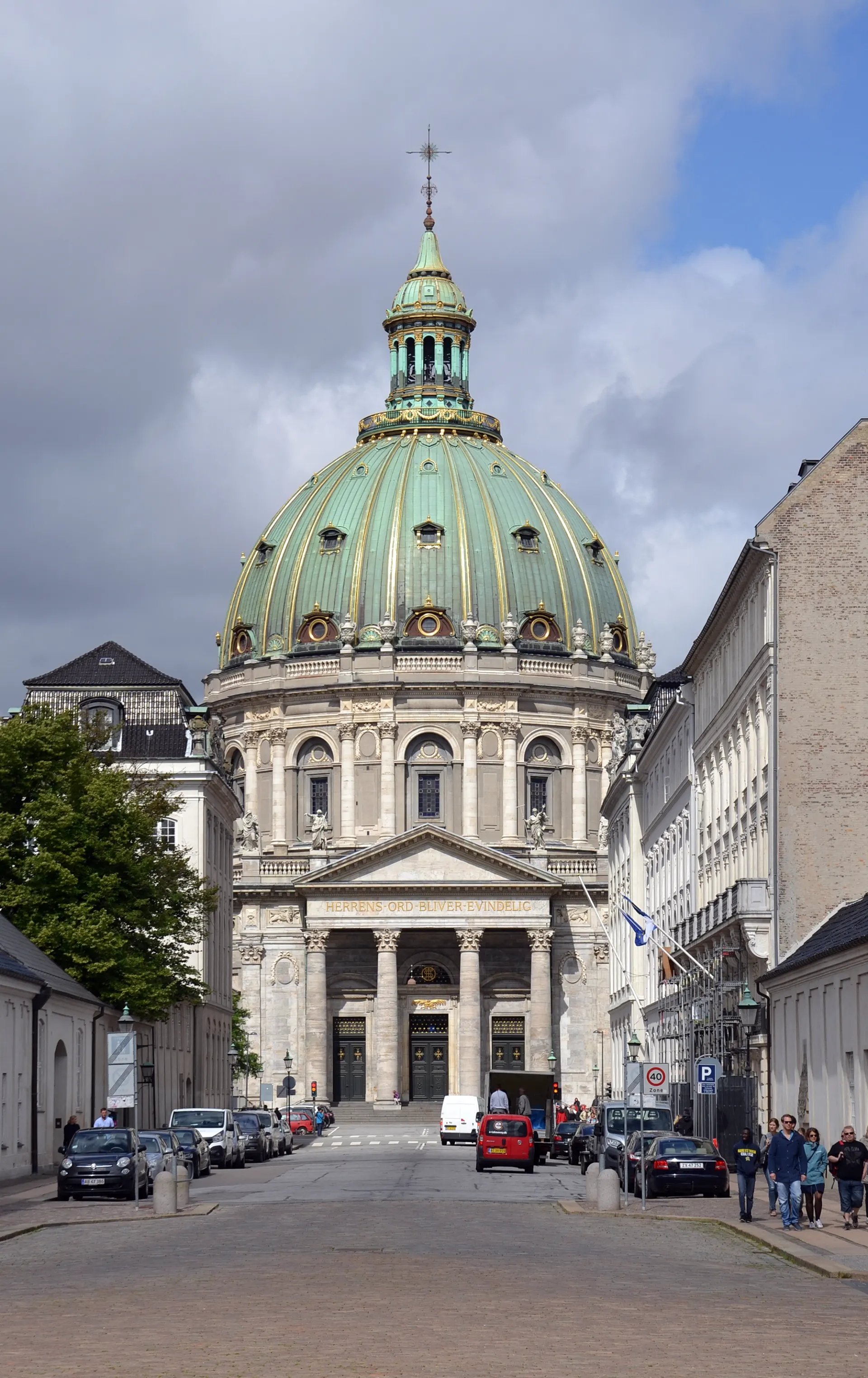
Frederik’s Church, often called the Marble Church, lifts a dome above the surrounding streets. Begin with the outside silhouette: the rounded roof, the portico and the streets that reveal it in pieces. The church’s own history dates its consecration to 1894 after a long, interrupted construction. The name is familiar, but the building is also an active parish church with worship taking priority over sightseeing.
The July 2015 exterior photograph is paired with two May 2012 interior photographs. Switching between them changes both scale and setting: from the street-facing building to the decorated organ, altar and curved interior wall. These are historical records, not confirmation that the door is open today. Their different original proportions share the same chapter frame, keeping the page layout steady as you compare the views.
The chapter’s April 2026 Google fragment is outside on Bredgade, near number 49. Three street positions reveal the church obliquely as nearby façades move across the view; the camera never goes through the door. Along-route exploration separately includes an August 2017 interior panorama, checked for turning but not forward movement. Choose that scene if you want to inspect the interior’s columns and seating. For a real visit, check the church’s admission information and any service-related changes. A dome tour is a separate arrangement, not part of either the photographs or the 360° scene.
Real-travel note
Chapter interaction stays on Bredgade outside. A separate August 2017 interior panorama is look-around only; current entry, services and dome tours need separate checks.
Compare the wider setting, a closer subject and a different view or date.
Chapter 5 · Green earth and water
Finish at Kastellet’s rampart landscape
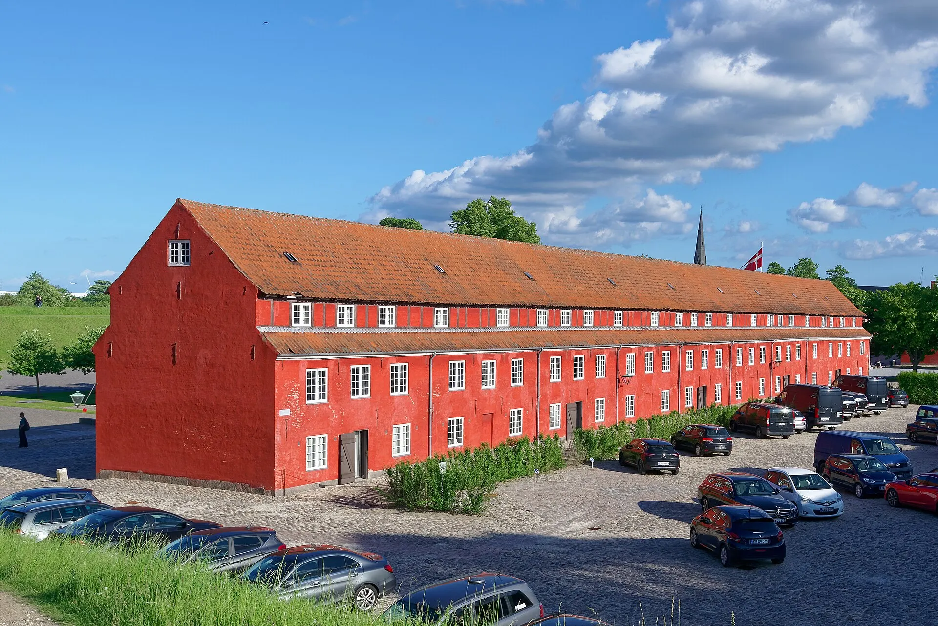
At Kastellet, the city’s hard edges give way to grass, trees and water. A star-shaped fort is not easy to grasp from ground level, so begin with smaller relationships: the moat below a bank, the line of a path and the roofs inside the earthworks. Copenhagen’s municipal guide describes a green setting that remains an active military garrison. Its park-like appearance does not make every door or working area public.
The three chapter photographs record different views in 2015, 2017 and 2022. Compare approaches, buildings and their surrounding space rather than assuming they form an entry-to-exit sequence. Their dates matter: foliage, maintenance and access arrangements can change. No photograph verifies that a particular military building is open, or that a route across grass is a permitted public path.
The September 2010 interactive fragment is on a rampart path beside the moat near the western side. Its three linked positions show trees, water and changing views along the bank; you can move a little and return. This is deliberately labelled older imagery, not a current-condition inspection or a circuit of the fort. Additional scenes near St Alban’s Church and the Gefion Fountain provide a different southern approach, each as a separate look-around. For an actual visit, consult Danish Defence’s current access rules, stay on permitted paths and assess slopes and uneven surfaces independently. Finish with the landscape, without turning a historical visual fragment into live navigation.
Read further: Copenhagen’s Kastellet: why a fortress needs a windmillReal-travel note
September 2010 rampart-path fragment, not current access or a full circuit. Active military site; posted rules and current Defence information take precedence.
12 reviewed experiences
Explore along the route
Step into the places along this journey. Choose a view independently of the story chapters. Free previews do not count toward chapter progress. Return to the journey above to continue through its stops.
Find your bearings around Kongens Nytorv Short observation sequence
July 2026: three road-camera positions near Kongens Nytorv 21, with traffic, bicycles and the tree-lined square. Not a pedestrian crossing or the square interior.
Reviewed 2026-10-20 · Nearby viewpoint
Explore at your own pace; these views do not count toward chapter completion. Check each point's coverage note before navigating provider imagery. Availability may change.
Sources
- Møllen — Danish Defence
- Kongens Nytorv — Visit Copenhagen
- Nyhavn — Visit Copenhagen
- Nyhavn harbour — Visit Copenhagen
- Amalienborg Palace — Visit Copenhagen
- History of Frederik’s Church — Frederik’s Church
- Church admission and visiting — Frederik’s Church
- Kastellet — City of Copenhagen
- Use of Kastellet — Danish Defence
- Ofelia Plads — Ofelia Plads
- Amaliehaven — Visit Denmark / Visit Copenhagen
- History of St Alban’s Church — St Alban’s Church
- Gefion Fountain — Visit Copenhagen
- Windmill in the Kastellet.jpeg — Peter Glyn · Wikimedia Commons
- Kongens Nytorv 01.jpg — Superchilum · Wikimedia Commons
- Magasin du Nord at Kongens Nytorv, Copenhagen.jpg — Dicklyon · Wikimedia Commons
- Hotel d’Angleterre, Kongens Nytorv 34, Copenhagen.jpg — Thomas Dahlstrøm Nielsen · Wikimedia Commons
- Kopenhagen (DK), Nyhavn -- 2017 -- 1538.jpg — Dietmar Rabich · Wikimedia Commons
- Kopenhagen (DK), Nyhavn -- 2017 -- 1536.jpg — Dietmar Rabich · Wikimedia Commons
- 2018 - Nyhavn on sunset.jpg — Moahim · Wikimedia Commons
- Amalienborg-square-copenhagen.jpg — Visit European Castles · Wikimedia Commons
- Christian VIII's Palæ, Amalienborg Palace, Copenhagen, 20220617 0852 6679.jpg — Jakub Hałun · Wikimedia Commons
- Frederik 5 statue Amalienborg Copenhagen Denmark-2.jpg — Jebulon · Wikimedia Commons
- Marmorkirken, Copenhagen (by Pudelek).JPG — Pudelek · Wikimedia Commons
- Marmorkirken interior - Copenhagen - DSC07831.JPG — Daderot · Wikimedia Commons
- Marmorkirken interior - Copenhagen - DSC07832.JPG — Daderot · Wikimedia Commons
- Kastellet, Copenhagen, Denmark, 20220616 1836 6556.jpg — Jakub Hałun · Wikimedia Commons
- Kastellet, Copenhagen (by Pudelek) 02.JPG — Pudelek · Wikimedia Commons
- Kopenhagen (DK), Kastell von Kopenhagen -- 2017 -- 1601.jpg — Dietmar Rabich · Wikimedia Commons
- Ofelia Plads 01.jpg — Ramblersen · Wikimedia Commons
- Amaliehaven - DSC07125.JPG — Daderot · Wikimedia Commons
- St Albans Church Copenhagen 2019.jpg — Marco Almbauer · Wikimedia Commons
- Gefion Fountain (Copenhagen).jpg — Fraser Mummery from Liverpool, England · Wikimedia Commons


Your journey, remembered.
Explored 0 of 5 stops. Explore every stop to unlock your keepsake.
5 stops to your keepsakeExplore every stop to share or download your keepsake.
Prepare a harbour-side visit
Choose which scenes deserve more time, then arrange current walking connections and admission separately.
Official sources checked:
Connect squares, water and green edges
Suggested order: Kongens Nytorv → Nyhavn → Amalienborg → Frederik’s Church → Kastellet. Roughly 3 km is an editorial planning estimate, not a measured track. Allow 2–3 hours outside, longer for gardens, Ofelia Plads, the fountain or indoor visits. The stop order is a story structure, not turn-by-turn navigation.
Separate the virtual view from entry
Amalienborg remains a working royal setting; leave guards and entrances space. Check museum arrangements separately. At Frederik’s Church, worship takes priority and access can change; a historical interior panorama does not include admission or a dome tour.
Plan around water, cycles and military use
Stay clear of harbour edges and moorings, leave cycle routes free and use current pedestrian crossings rather than copying a road-camera position. Kastellet remains an active military site: follow posted access rules and keep to permitted paths. Assess rampart slopes and uneven paving independently.