
Zhangjiajie: From Golden Whip Stream to Tianzi Mountain
Follow a real visiting order from the Forest Park south gate through a sandstone gorge, then rise by elevator and park shuttle onto the Yuanjiajie and Tianzi Mountain terraces.
Guided visual journey
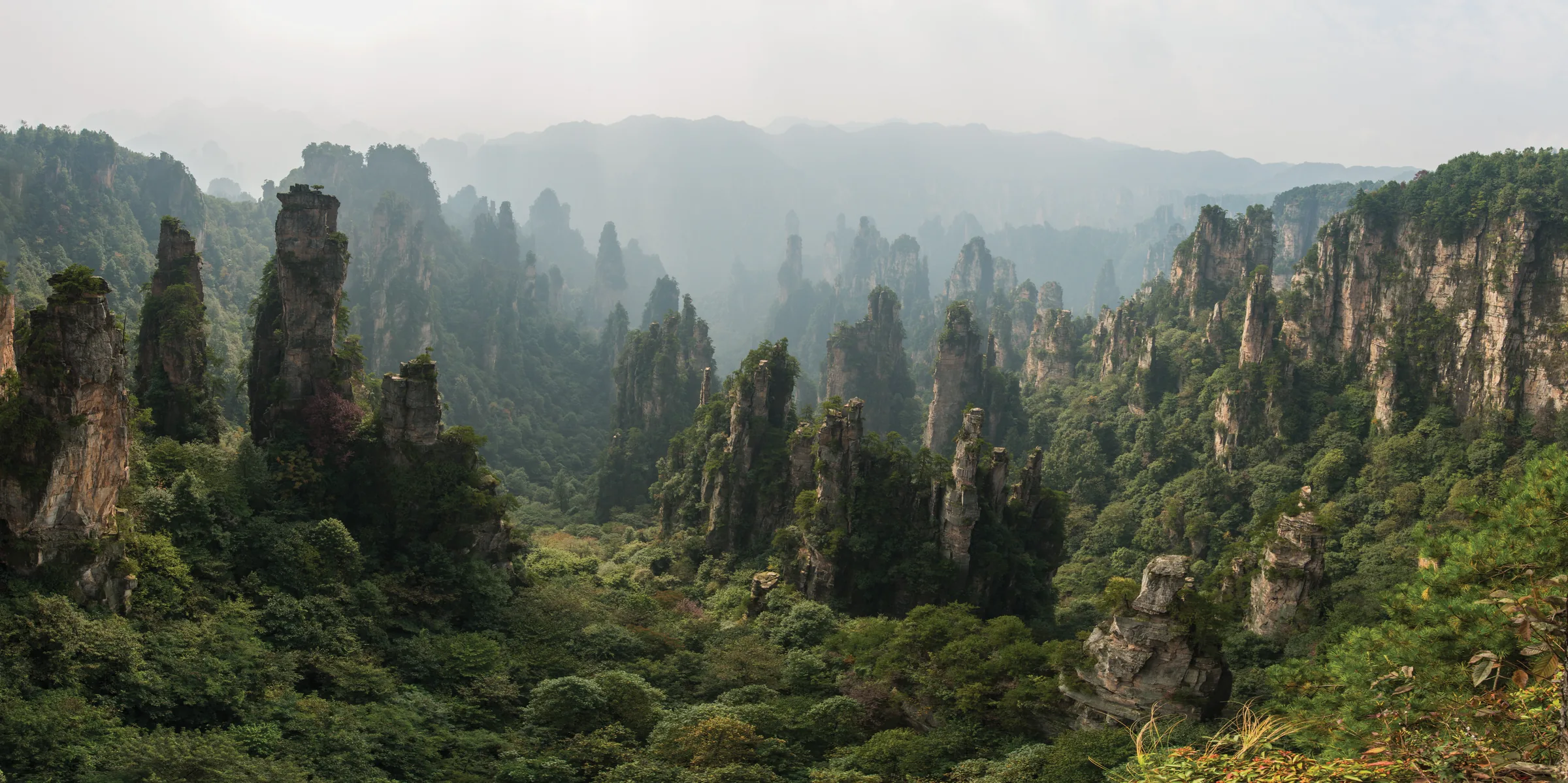
Licensed documentary photograph (resized for web) · chensiyuan · CC BY-SA 4.0
Reading mode
Six stories to read at your own pace
Chapter 1 · A park inside a larger landscape
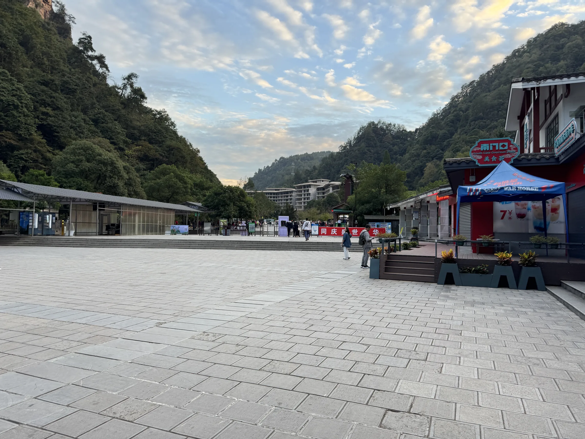
Forest Park gateway: entering the sandstone forest
The south gate of Zhangjiajie National Forest Park is a practical threshold, not a scenic climax. Buses, ticket checks and the so-called Oxygen Plaza sit at the edge of a sandstone landscape that visitors often call simply “Zhangjiajie.” That everyday name is larger than one park. The quartz-sandstone peak forest belongs to the Wulingyuan Scenic and Historic Interest Area, inscribed by UNESCO in 1992. Zhangjiajie National Forest Park, established in 1982 as China’s first national forest park, is one of the protected units inside that larger landscape, together with neighbouring scenic and reserve areas such as Tianzi Mountain.
Standing here, you are still in the valley system. The pillars that dominate photographs are not yet a skyline around the gate; they gather as you travel north along Golden Whip Stream and later, by elevator and park shuttle, onto the plateau viewpoints of Yuanjiajie and Tianzi Mountain. The spatial relationship is vertical as much as linear. Valley walks and mountain terraces are connected by managed park transport, not by a single hillside trail that a visitor can treat as an ordinary city stroll.
Hunan forestry accounts of the park emphasise both the sandstone landform and the forest cover that gives the gate its “oxygen” nickname. Treat that as ecology and tourism language, not as a medical claim. What the gate does make clear is jurisdiction and sequence: you enter a national forest park that is also part of a World Heritage landscape, then follow an official visiting order that later leaves the stream for Water Winding Four Gates, the Bailong Elevator and the upper scenic areas.
Begin by reading the approach as infrastructure. Queues, ticket rules and shuttle stops change. The geology does not. The rest of this journey is about how those two facts meet on the ground.
Real-travel note
This is an organised scenic area, not an open city walk. Recheck current tickets, reservations, opening status and transport notices through official park channels before you travel, and expect queues at the gate.
Chapter 2 · Into the gorge
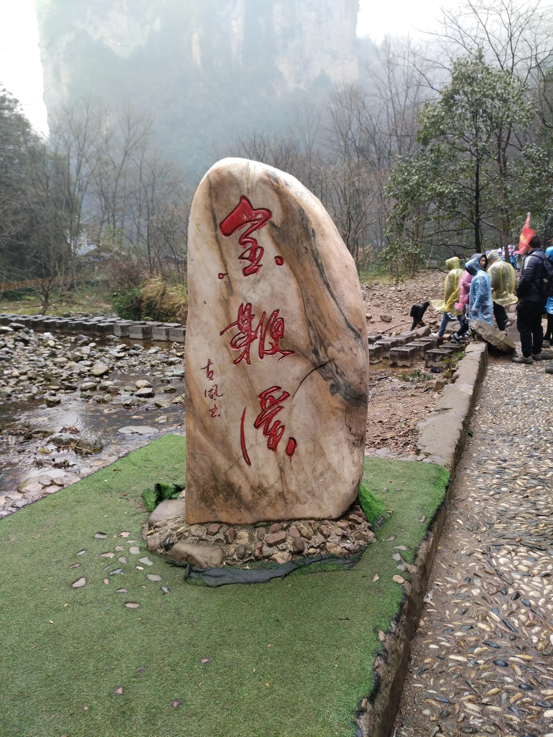
Golden Whip Stream: walking into the gorge
Golden Whip Stream is the first place where Zhangjiajie’s advertised landform becomes a walking environment. The path follows water between steep quartz-sandstone walls, with trees, humidity and the sound of the stream close at hand. Hunan forestry describes the stream as 5,710 metres long. That figure is a measure of the gorge corridor, not a promise that every visitor will walk every metre at the same speed, or that the path is as even as a city pavement.
The walk from the south-gate / Oxygen Plaza area to the stream start is short; the gorge itself is the longer commitment. Expect damp stone, roots, bridges and sections where other visitors bunch together. In rain the surfaces become slippery. In summer the valley can feel enclosed and humid; in winter it can be cold and wet under the cliffs. None of those conditions is a reason to skip the chapter, but they are reasons not to describe it as an easy urban ramble.
Look up as well as along. The stream is the floor of a peak-forest, and the walls you pass are the bases of pillars that will later appear as silhouettes from Yuanjiajie and Tianzi Mountain. The official visiting order uses this valley because it is one of the few places where a traveller can move through the landform on foot before changing mode. That is the point of the chapter: to feel the sandstone from below, at walking pace, before the journey asks you to rise.
Do not treat every side path or unnamed pool as a required stop. The documented identity of this chapter is the named stream corridor. Keep to managed walkways, give way on narrow bridges, and remember that the destination of this valley walk is not a summit. It is Water Winding Four Gates, where the route changes character.
Real-travel note
Allow time and sure footing. The gorge walk is longer than the approach from the gate, with humidity, possible rain, steps and crowding. Carry water and do not assume the path is a short, level promenade.
Chapter 3 · Valleys meet
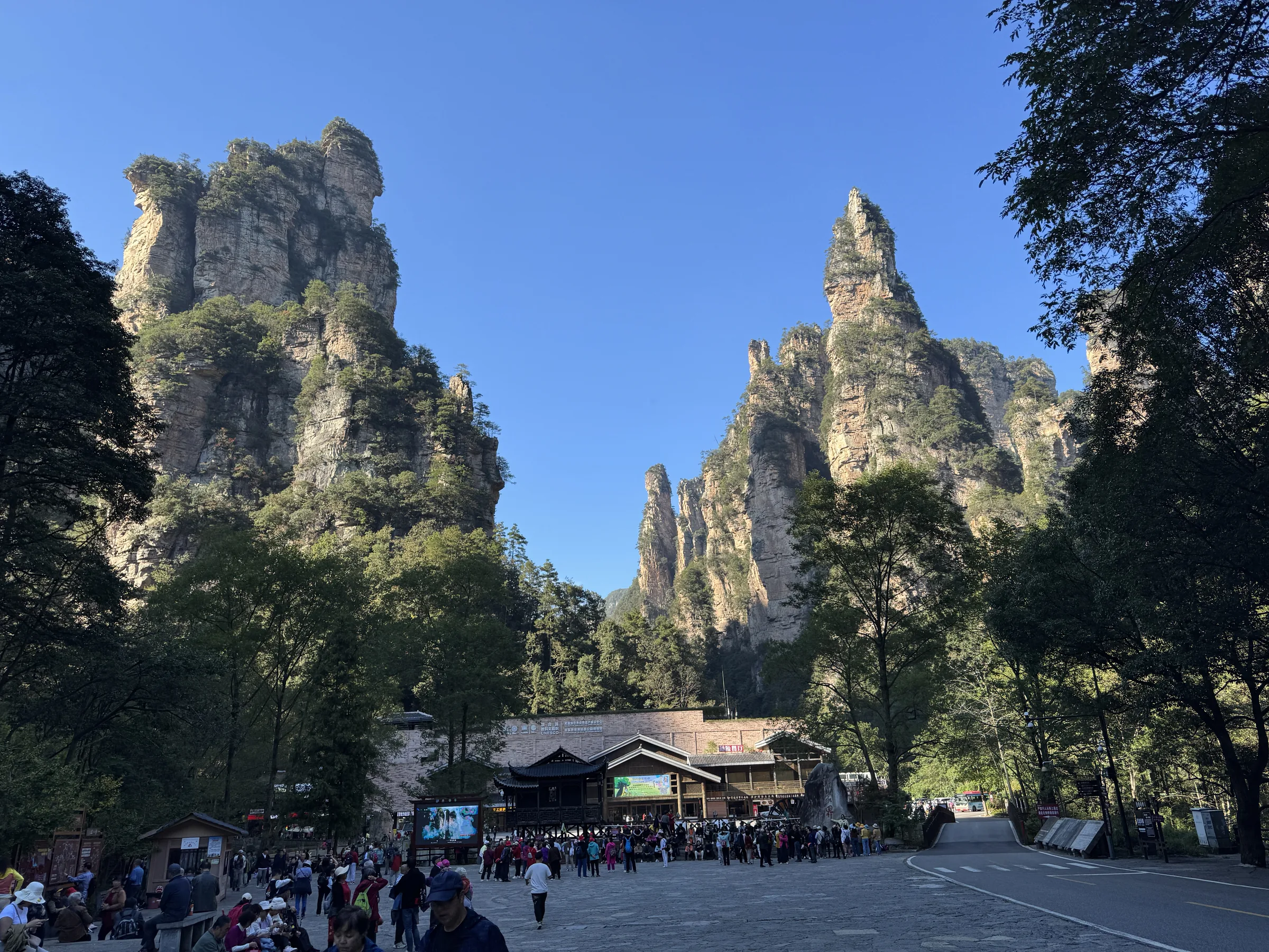
Water Winding Four Gates: where valleys and routes meet
Water Winding Four Gates takes its name from water arriving from several directions in a widening of the valley. It is the place where the Golden Whip Stream walk stops feeling like a single corridor and starts to look like a junction. Official tourism material treats the site as a hinge in the Wulingyuan visiting order: behind you is the gorge; ahead are the Bailong Elevator, Yuanjiajie and the mountain terraces.
That hinge is practical as well as scenic. Walkers, park shuttles and the approach to the elevator share a constrained valley floor. The sandstone walls still dominate the view, but the rhythm of the day changes. You may wait, change mode, or walk a short connection that is no longer the long stream path. Calling this a simple “next photo stop” would hide the reason the chapter exists. Four Gates explains why Zhangjiajie cannot be sold as one continuous hike.
Stand still long enough to read the junction. Water, cliffs and passenger movement occupy the same narrow ground. The photograph for this chapter shows the valley hub rather than the elevator cabin, which is the honest picture of the place: a meeting of landforms and logistics. From here the journey is transport-assisted. The next chapter is not further down the stream; it is a vertical shift out of the gorge.
Queues and vehicle loops vary with season and crowd control. This page does not invent a waiting time. What it can say, from official transport guidance, is that Four Gates is where valley walking and park transport are meant to meet. If you are choosing whether the day still fits, this is the moment to decide, before you commit to the elevator and the upper circuit.
Real-travel note
Expect a change of pace, possible waiting and mixed pedestrian and vehicle movement. This is a transfer hub. Confirm the current way to the elevator lower station with on-site and official notices rather than assuming a single footpath.
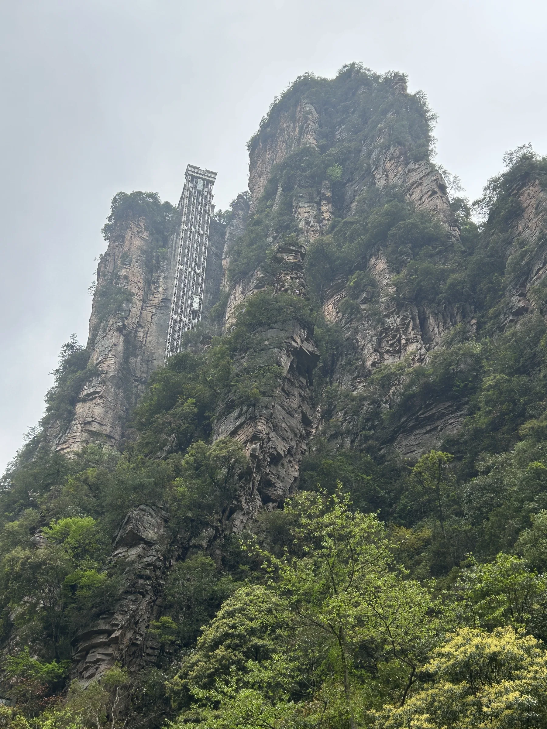
Chapter 4 · A vertical shortcut
Bailong Elevator: rising from valley to plateau
The Bailong Elevator is a glass-fronted outdoor lift built against a sandstone cliff. Official Hunan tourism material records a rise of 326 metres and a ride of one minute 58 seconds. In the space of that short ascent, the journey leaves the stream floor for the upper peak-forest. The change is not metaphorical. Valley walking and plateau walking are different climates, different views and different kinds of effort, joined here by a machine rather than by a continuous trail.
That convenience is also a conservation and crowding question. Wulingyuan is a World Heritage landscape precisely because of the quartz-sandstone pillars and the forests around them. Large scenic-area infrastructure makes the upper viewpoints reachable for many more people, and it concentrates those people at stations, queues and terrace paths. This chapter does not pretend to settle the debate. It asks visitors to notice the tension: access and protection occupy the same cliff.
From the cabin, the gorge becomes a plan rather than a corridor. On busy days the wait can dwarf the ride. On quiet days the shaft still reads as an industrial insertion in a protected landform. Neither view is a reason to turn the elevator into folklore. It is a working public lift whose operating hours, queue system and possible closures belong to current park management, not to a static guidebook sentence.
When you step out above, you are not “still on Golden Whip Stream.” You are on the Yuanjiajie side of the mountain, where walking resumes on terraces and where the next long move toward Tianzi Mountain will again be a park shuttle rather than a gorge path.
Real-travel note
This transfer is an elevator, not a walk. Allow extra time for queues, and recheck whether the lift is running. People who cannot use stairs, lifts or crowded cabins should judge access from current official information.
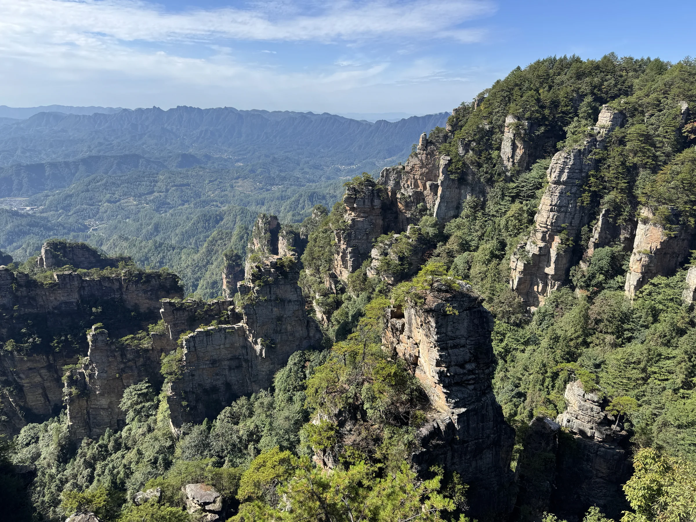
Chapter 5 · On the pillars
Yuanjiajie: above the sandstone pillars
Yuanjiajie is where the peak forest becomes a platform. After the elevator, paths and viewing decks run along the top of quartz-sandstone columns, so the pillars stand beside and below you instead of only ahead. Official Hunan tourism material groups Yuanjiajie with the Bailong Elevator and nearby lookouts such as Mihuntai. The landform is the same geology seen from Golden Whip Stream, rotated into plan view.
The photograph for this chapter shows a ridge of peaks that visitors often compare to a wall. The comparison is visual, not architectural: it is sandstone, vegetation and air. Natural bridges and cliff platforms in this area are part of the same plateau circuit, but names on souvenirs and film marketing are not automatically facts. This journey uses the official scenic-area identity, the verified coordinate and the licensed photograph. It does not borrow a movie title to explain the rocks.
Walking here is still walking, but it is not the gorge walk. Surfaces can be wet, stepped and exposed to drop-offs behind railings. Cloud can erase the view in minutes. The temperature is often different from the valley you left. Those are ordinary mountain conditions, and they are the reason a photograph taken on a clear day cannot be treated as a guarantee.
From Yuanjiajie the official circuit continues toward Tianzi Mountain by park shuttle, with more walking at the viewing areas. If you stop here, you have already changed elevation and mode several times. If you continue, you are choosing weather and time on the higher terraces, not another stretch of Golden Whip Stream.
Real-travel note
Stay on marked walkways and treat drop-offs as real. Cloud, rain and crowding can close or slow platforms. The next move toward Tianzi Mountain is a park shuttle, not a continuation of the gorge path.
Chapter 6 · Cloud and distance
Tianzi Mountain: a finale in cloud and stone
Tianzi Mountain is both a named viewing area and, in Hunan forestry records, a nature reserve. It sits in the same Wulingyuan sandstone landscape as the Forest Park and Yuanjiajie, but farther north and higher in the visiting sequence. Official routes reach it after Yuanjiajie by park transport, with walking at the terraces. The chapter is a finale because the journey has already used a gorge walk, a valley hub, an elevator and a plateau. It is not a finale because a photograph of peaks in cloud can be repeated on demand.
Weather is the honest subject. Cloud can fill the valleys and hide the pillars, or it can open for a few minutes and close again. Temperature and wind on the mountain differ from the stream. A clear image, including the landscape used on this page, records one condition. It is not a forecast. Travellers who need a guaranteed panorama should treat that as a reason to keep spare time, not as a reason to distrust the place.
The reserve status matters as more than a label. It places Tianzi Mountain inside a conservation geography, not only a viewpoint circuit. Walking remains on managed paths. Park shuttles, possible cableways elsewhere in the wider scenic area, and temporary closures belong to current operations. This journey does not add Tianmen Mountain, the glass bridge or other famous but off-route sites. The documented end is the Tianzi Mountain peak forest.
If the view is open, look back toward the geology you walked under in the morning. If it is not, the sequence still holds: valley, junction, lift, terrace, mountain. Either way, the question is no longer how to stitch a fake continuous walk. It is whether this transport-assisted day, with its effort and uncertainty, is a journey you want to make in person.
Real-travel note
Visibility, temperature and transport on Tianzi Mountain change quickly. Recheck official weather, shuttle and opening notices before you go, and do not treat a clear photograph as a promise of the same view.
Sources
- Wulingyuan Scenic and Historic Interest Area — UNESCO World Heritage Centre
- Zhangjiajie National Forest Park — Hunan Forestry Department
- Hunan Tianzi Mountain Nature Reserve — Hunan Forestry Department
- Zhangjiajie route — Hunan Department of Culture and Tourism
- Yuanjiajie, Bailong Elevator and Mihuntai — Hunan Department of Culture and Tourism
- Wulingyuan scenic area transport guide — Hunan Department of Culture and Tourism
- Wulingyuan one-ticket system background — People’s Government of Hunan Province
- Zhangjiajie National Forest Park south gate — OpenStreetMap
- Golden Whip Stream — OpenStreetMap
- Water Winding Four Gates — OpenStreetMap
- Bailong Elevator — OpenStreetMap
- Natural great wall, Yuanjiajie — Wikimedia Commons
- Tianzi Mountain — OpenStreetMap
- Zhangjiajie National Forest Park — Wikidata
- Bailong Elevator — Wikidata
- Tianzi Mountain — Wikidata
- Zhangjiajie entrance 01 — Wikimedia Commons
- Golden Whip Stream — Wikimedia Commons
- Bailong Elevator area 02 — Wikimedia Commons
- The real Great Glass Elevator — Wikimedia Commons
- Natural great wall 01 — Wikimedia Commons
- Tianzi Mountain, Wulingyuan — Wikimedia Commons


.jpg)

Your journey, remembered.
The keepsake unlocks when you reach this section.