
Asakusa and the Sumida River
Use this walking route to leave Kaminarimon, follow Nakamise to Senso-ji and Asakusa Shrine, then cross Sumida River Walk to the east bank.
Guided visual journey
Reading mode
Six stories to read at your own pace
Chapter 1 · The lantern, then the street
Kaminarimon
The walk begins under the lantern, not on a station concourse. Asakusa Station is the practical way in: the Tokyo Metro Ginza Line, the Toei Asakusa Line and the Tobu Skytree Line all use that name. The Go Tokyo page for the district, updated on 4 February 2026, sets Kaminarimon, Nakamise, Senso-ji and the Sumida River in one neighbourhood, with Azuma Bridge and Tokyo Skytree as the wider view. Times printed on the waterfront page — about seven minutes from Ginza Line Exit 5, about three minutes from the Tobu north exit — measure the walk to Sumida River Walk and TOKYO mizumachi. They are not the walk from the train to this gate. Come out, find the lantern, and start there.
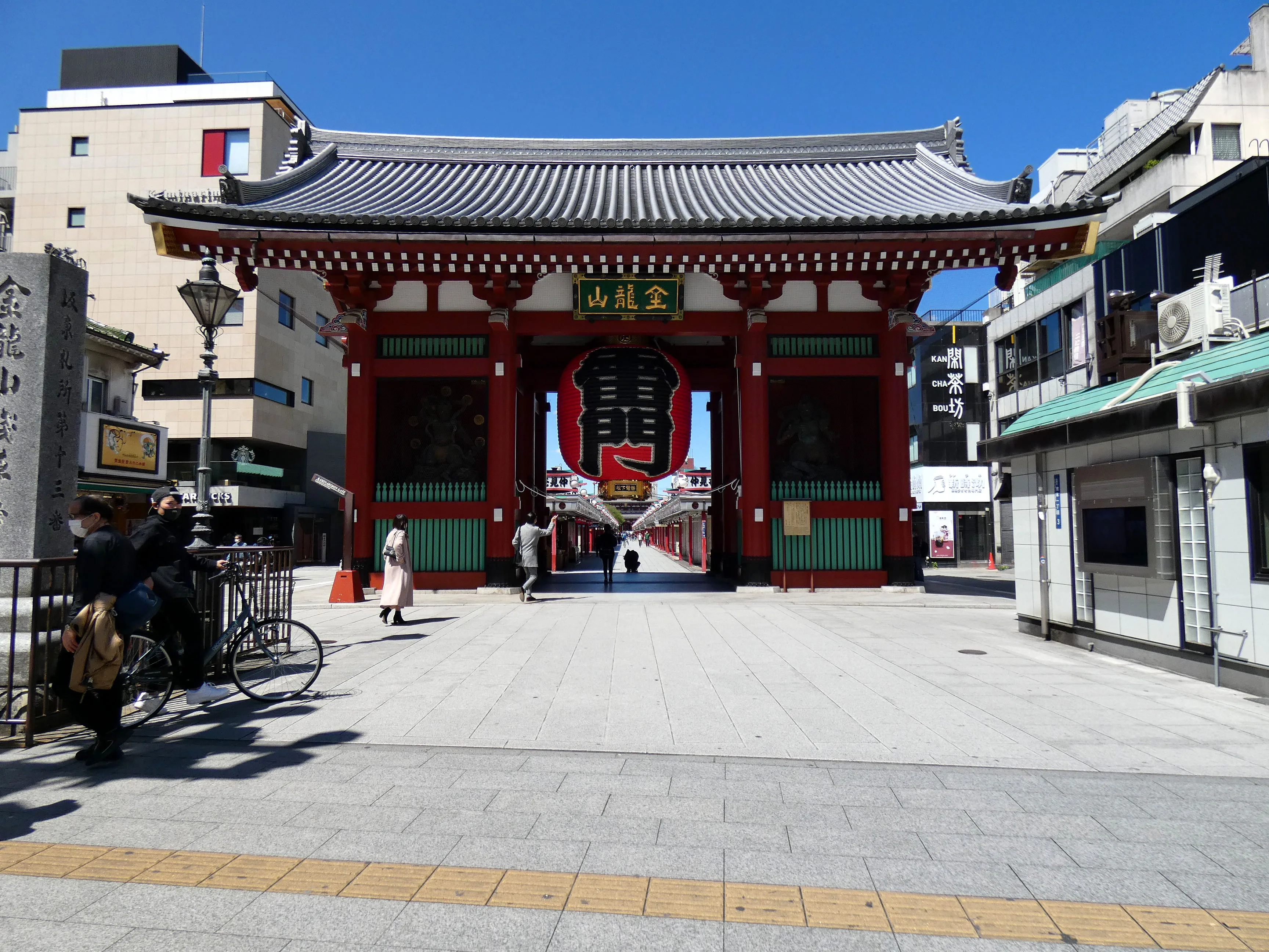
What fills the opening is the gate itself. A giant red lantern hangs in it, marked 雷. Above, the plaque reads 金龍山. The photograph was made at 13:27 on 19 April 2020, during the coronavirus state of emergency. The street beyond the gate is unusually quiet for Asakusa. On an ordinary day the same opening is a crowd. Treat the picture as the architecture, not as a promise about how many people you will meet.
The temple’s English page is specific about this gate. Kaminarimon was first built in 942. It burned in December 1865. The gate standing here was rebuilt in 1960 with a donation from Matsushita. That is a rebuilt landmark with a documented fire and a documented reconstruction. The same page calls Nakamise one of the oldest shopping streets and sends you through this opening toward the hall.
An optional 360° view stands at the gate and lets you look around the lantern. It will not carry you up the shopping street. The next change is immediate and on foot: step through and the open approach becomes Nakamise. Leave room for people who have come to pray. Rain, festivals and temporary controls change the pace, so recheck before you treat the lantern as always open.
Real-travel note
Station exits and festival controls change. Recheck the day’s access before you go. This guide is not live navigation.
Chapter 2 · The shopping approach
Nakamise
Through the gate the neighbourhood becomes a shopping street. Nakamise-dori is lined with small shops and aimed at the temple; the central passage is open to the sky. The temple’s English page describes it as one of the oldest shopping streets. You are not collecting a second monument. You are on the approach, choosing whether to stop for a snack or keep walking toward the hall.
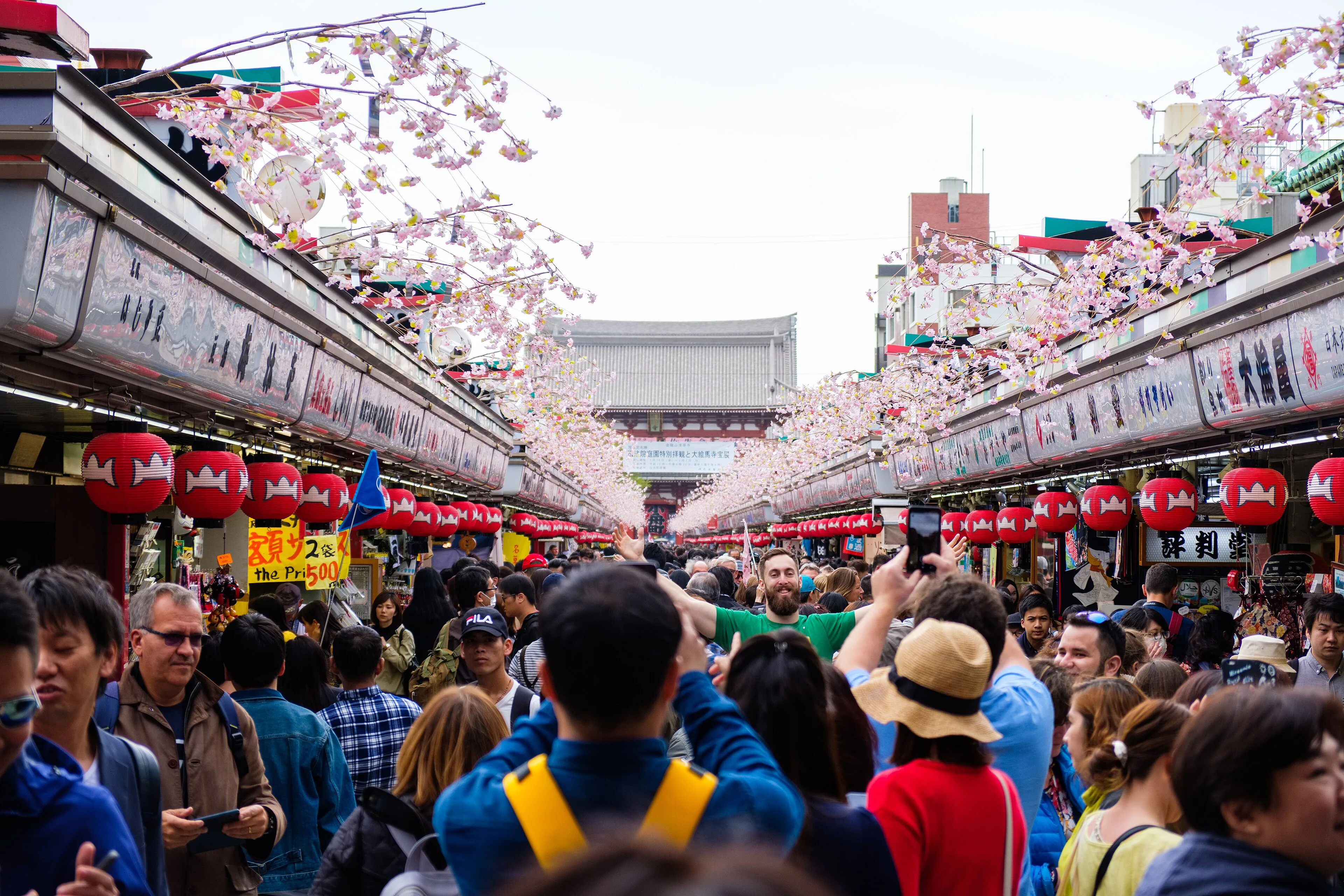
The photograph looks up that street from near the gate. It was made at 12:28 on 7 April 2018. Red lanterns hang in a row, cherry decorations cross overhead, and Hozomon stands at the far end above a crowd. The blossoms and the decorations belong to that April. They are not a promise for another month. The camera position is nearer the gate than the mapped pin, which sits further along the same street, still on Nakamise-dori.
OpenStreetMap draws the shopping street for about 297 metres from the gate to Hozomon. This chapter’s pin is partway along it. From the gate the pedestrian router returned about 144 metres and two minutes on 29 September 2026. The rest of the street, including Hozomon, belongs to the walk toward the hall. Hozomon was rebuilt in 1964. It is the second gate you pass, not its own chapter.
An optional 360° view is one point on Nakamise. A morning frame can show shutters still down. It will not match the busy midday in the photograph, and it will not walk you to the hall. Give shop staff room. The street is narrow, and a festival day can stop the easy pace. Beyond the shops, the approach opens into the temple court.
Real-travel note
Shops close, and the street is often crowded. Recheck festival notices before you go.
Chapter 3 · The hall, and a story the temple tells
Senso-ji
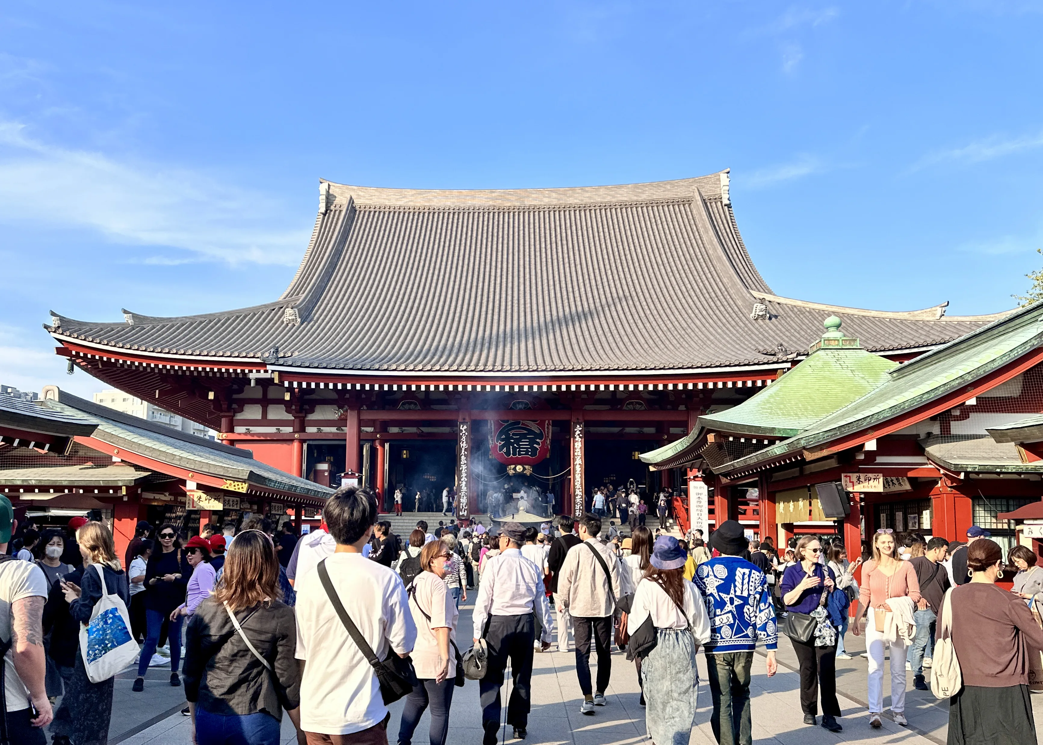
Past the shops and Hozomon, the temple court opens toward the hall. Senso-ji’s main hall faces the approach, with incense in front of the steps and a crowd that rarely clears for long. The photograph was made at 14:37 on 4 November 2023. Smoke, the red-and-white hall and the people on the pavement are that afternoon. The address on the temple’s English page is 2-3-1 Asakusa, Taito-ku.
The temple tells an origin that should stay labelled as temple tradition. On 18 March 628, the brothers Hinokuma Hamanari and Hinokuma Takenari are said to have found a statue of Kannon in the Sumida River. That story is the temple’s own account of how the place began. It is not the same kind of statement as a recorded fire or a recorded rebuilding.
The documented sequence is separate. The temple’s English page says that in 645 a priest named Shokai built a hall for the Kannon and, after a dream, hid the statue. It remains a hidden Buddha, a hibutsu. Ennin made a stand-in. Tokugawa Ieyasu designated the temple in 1590. The main hall built under Iemitsu was destroyed in the air raid of 10 March 1945 and rebuilt in 1958. Hozomon was rebuilt in 1964. The five-storey pagoda was rebuilt in 1973. Nitenmon is an Important Cultural Property; the present gate dates to 1649 and was restored in 2010. The principal image is not open to view. The prayer phrase printed on the temple page is Namu Kanzeon Bosatsu.
Hours are a thing to recheck, not a rule carved into the visit. The Japanese guide, read on 29 September 2026, lists the main hall from 6:00 to 17:00, and from 6:30 in October through March. For other halls it says to ask. The phone given for weekdays, 9:00 to 16:30, is 03-3842-0181. No admission price was printed clearly enough to copy here. Do not invent one.
An optional 360° view is the outer hall: red pillars, lanterns and the offering area. It lets you look around that court. It will not walk you across to Asakusa Shrine. From the hall the next turn is short and inside the precinct, northeast, on paths the router does not name.
Real-travel note
Main-hall hours change by season, and other halls ask you to check. Recheck the temple before you go. The 628 story is temple tradition.
Chapter 4 · The shrine beside the temple
Asakusa Shrine
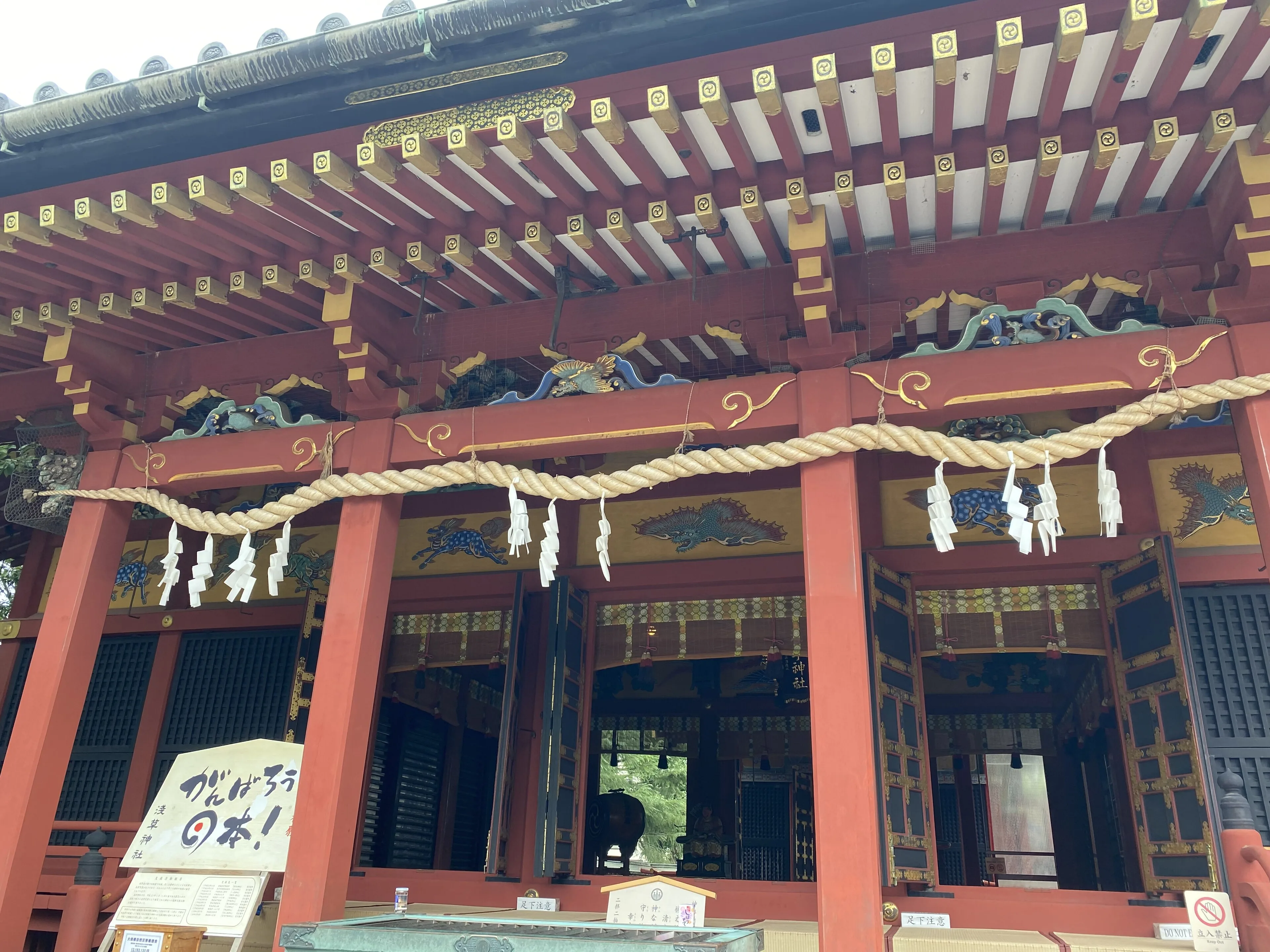
A short walk northeast of the hall, the visit changes religion without leaving the precinct. Asakusa Shrine stands beside Senso-ji. The photograph, made at 09:53 on 15 August 2023, faces the worship hall: a thick shimenawa, paper streamers, the characters 浅草神社, and a notice asking you to watch your step. That is the haiden. The camera position sits a little south of the mapped pin, still at the shrine.
The shrine tells its own origin, and it should stay labelled as shrine tradition. The three founders, the Sanja, and a dream oracle are the story the shrine gives for why it exists. The about page says the exact founding date is unknown. The shrine itself estimates late Heian to early Kamakura. That estimate is the shrine’s, not a dated document of a foundation year.
The later record is clearer. In the first year of Meiji the shrine was renamed Sanja Myojin. In Meiji 5 it became a village shrine. In Meiji 6 it became Asakusa Shrine. The buildings are a gongen-zukuri group: honden, heiden and haiden. The about page describes the complex as a 1649 gift of Iemitsu, and says it survived fires, war and the 1923 earthquake. It was designated a National Important Cultural Property in 1951 and repainted in 1996. The shinmei torii was built in September 1885, Meiji 18. The address is 2-3-1 Asakusa. The office phone is 03-3844-3183.
Office hours are not a claim that the grounds never close, and they are not a claim that the grounds are open all night. Read on 29 September 2026, the about page lists weekdays 9:00 to 16:00 and weekends and holidays 9:00 to 16:30. Recheck before you rely on either line. Behave as you would at a working shrine: the rope, the streamers and the hall are in use, not a set.
From the hall the pedestrian router needed about 127 metres and two minutes on unnamed precinct paths. An optional 360° view in the precinct can show a gate and a stall selling ofuda and omamori rather than the hall front in the photograph. It is a look around, not a path to the river. Leaving for the water is the long leg of this walk.
Real-travel note
Office hours were listed on 29 September 2026 and are not a 24-hour claim. Recheck the shrine before you go. The founding story is shrine tradition.
Chapter 5 · The river, at the Asakusa landing
Sumida Park and the landing
The precinct ends and the walk becomes a city street. From Asakusa Shrine to the river the pedestrian router returned about 634 metres and nine minutes on 29 September 2026. Most of that leg has no street name. Only a short stretch is Sukeroku Yume-dori. A straight line to the water is shorter. The figure here is the path the router actually took, not a field survey and not a radius drawn on a map.
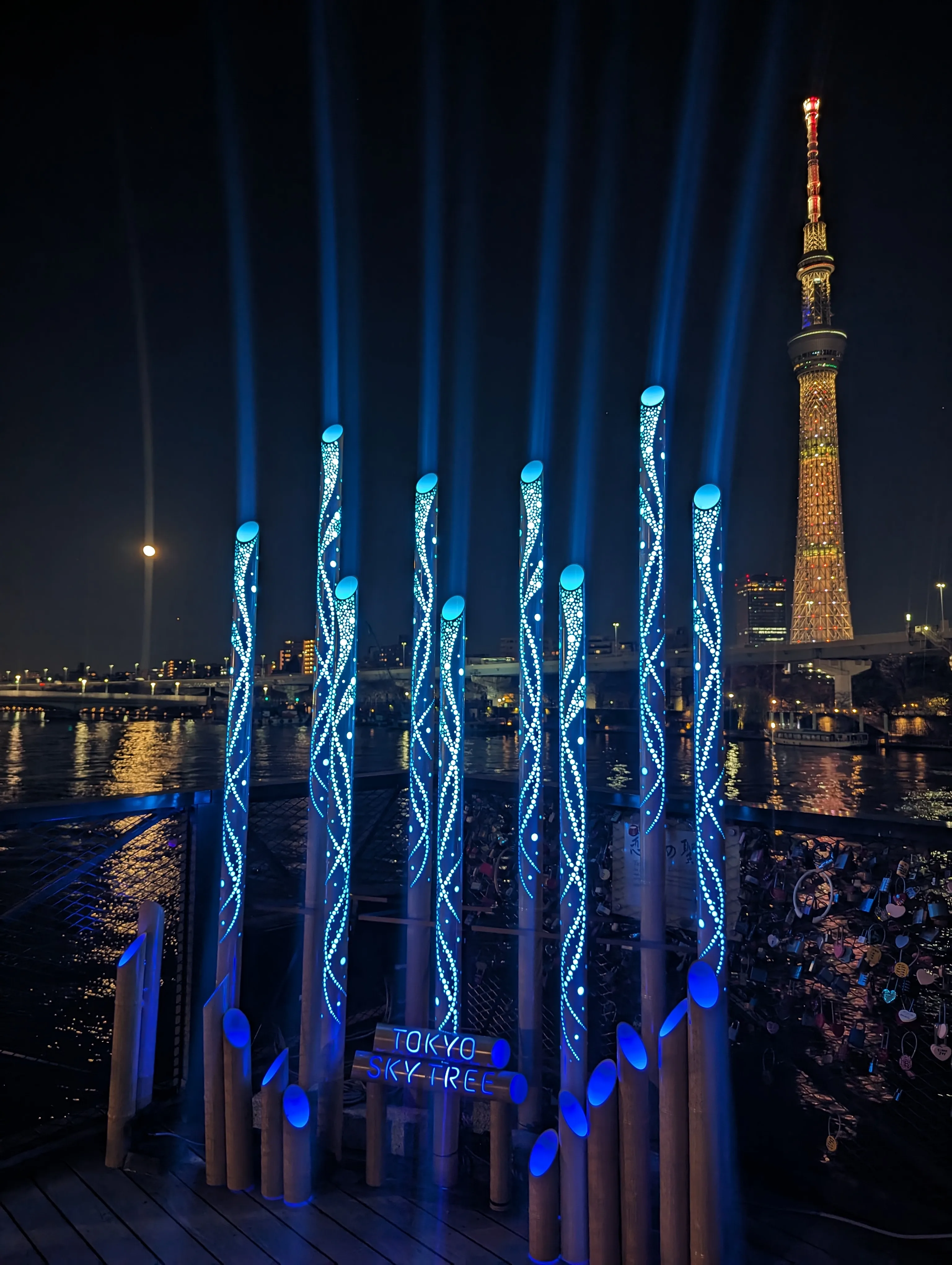
The pin is the Asakusa end of the pedestrian bridge, inside the mapped extent of Sumida Park. It is not the middle of the park, and it is not a lawn. The photograph was made at 19:37 on 7 December 2025, on that deck: the river, Tokyo Skytree, a blue light installation and love locks. The blue columns belong to that night. They are not a permanent promise, and they are not a picture of cherry trees along the bank. If you came for blossoms, this frame will not show them.
Go Tokyo’s page for the walk, updated on 27 November 2025, gives the address as 1 Mukojima, Sumida City, lists hours of 7:00 to 22:00, and describes a 160-metre promenade with a glass floor, linking the Senso-ji area to Tokyo Skytree Town. TOKYO mizumachi, under the Tobu line, opened in June 2020; shop hours vary. A separate riverside page, updated on 31 March 2026, is a longer stroll from the Sumida toward Ryogoku. Do not copy its timing onto these six stops.
There is no verified 360° view at this landing: a nearby panorama resolved beneath or beside the bridge, so the photograph is the view for this chapter. The crossing is the last short walk, on the promenade itself. The three-minute and seven-minute station times on the official page are ways to reach this waterfront, not a shortcut back to Kaminarimon.
Real-travel note
The promenade’s 7:00–22:00 hours were listed on 27 November 2025. Recheck before you go. The blue lights are that December night, not a forecast.
Chapter 6 · The east end of the bridge
Sumida River Walk
The last change is the bridge itself. From the Asakusa landing the pedestrian router stays on Sumida River Walk and reaches the east end in about 172 metres and two minutes. The official page lists the promenade as 160 metres. The extra metres in the router figure are this leg’s approach along the same footbridge, checked on 29 September 2026. They are not a claim that the published length is wrong, and they are not a walk along Azuma Bridge. Azuma Bridge is the road bridge nearby. This path is the pedestrian deck.
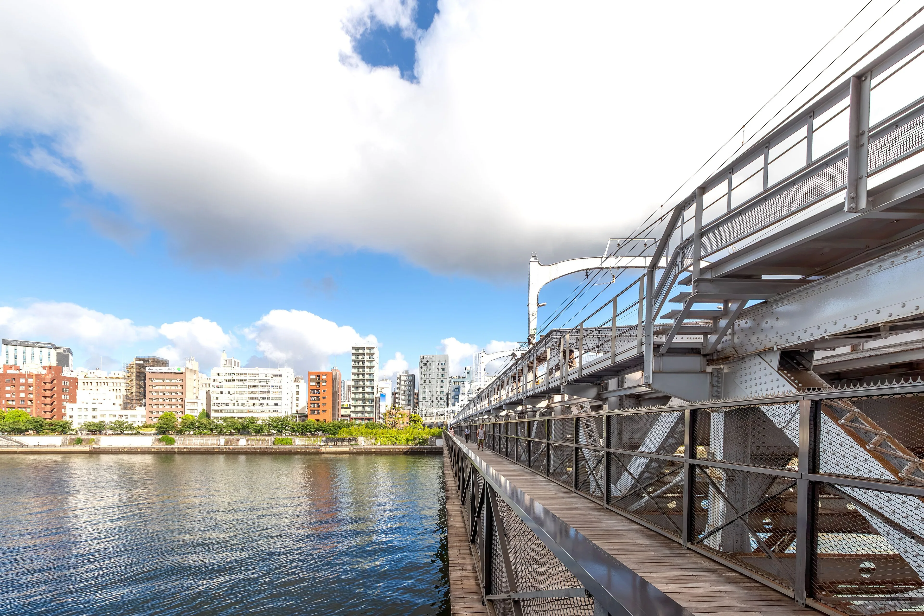
The photograph was made at 07:08 on 8 August 2026. It shows the timber deck beside the white steel truss, with the river on the left and the far bank ahead. It is a morning, not the blue night installation at the other end of the bridge. The camera position sits on this east end. There is no optional 360° view here. The picture is the chapter.
TOKYO mizumachi opened in June 2020 under the Tobu line, just beyond this end. Shops set their own hours. Go Tokyo’s district page is the place to recheck them, along with the promenade’s 7:00 to 22:00. Neither line is a promise for the morning you choose.
This edition stops at the east end. Tokyo Skytree Town continues past TOKYO mizumachi and is a different visit: more time, a different building, and a decision you can make after you have crossed. To leave, use the Tobu Skytree Line at the east-bank stations, walk back the way you came, or recheck a water-bus if that is the day you want on the river. The whole line from the gate to this end is about 1.3 kilometres. The walking between the six points is about eighteen minutes. Allow about two hours once you add the hall, the shrine and time on the deck. Crowds will make it longer. Nothing here is live navigation or a promise that a path will be open.
Real-travel note
Promenade hours and shop hours at TOKYO mizumachi change. Recheck before you go. This walk ends at the east end of the bridge.
Sources
- Asakusa — Go Tokyo
- Sumida River Walk — Go Tokyo
- Riverside walks — Go Tokyo
- Senso-ji — Senso-ji
- ご案内 — Senso-ji
- 浅草神社について — Asakusa Shrine
- 雷門 — OpenStreetMap
- 仲見世通り — OpenStreetMap
- 浅草寺本殿 — OpenStreetMap
- 浅草神社 — OpenStreetMap
- すみだリバーウォーク, Asakusa landing — OpenStreetMap
- すみだリバーウォーク, east end — OpenStreetMap
- Kaminarimon 2020-04-19 — Wikimedia Commons
- Crowds at Nakamise, Asakusa 2018-04-07 — Wikimedia Commons
- Sensoji 2023 — Wikimedia Commons
- Asakusa Shrine — Wikimedia Commons
- Sumida River Walk 2025-12-07 — Wikimedia Commons
- すみだリバーウォーク20260808 — Wikimedia Commons


Your journey, remembered.
The keepsake unlocks when you reach this section.