
Stockholm: from an old-town square to royal façades and open water
Explore Stockholm’s Gamla Stan and Riddarholmen in five chapters, with fifteen switchable photographs and independently checked interactive scenes. Small fragments of squares and lanes are not a continuous walk.
Begin the visual journeyPlan a real visit to Stockholm Old Town & Royal WaterfrontExplore 10 reviewed views along the routeGuided visual journey
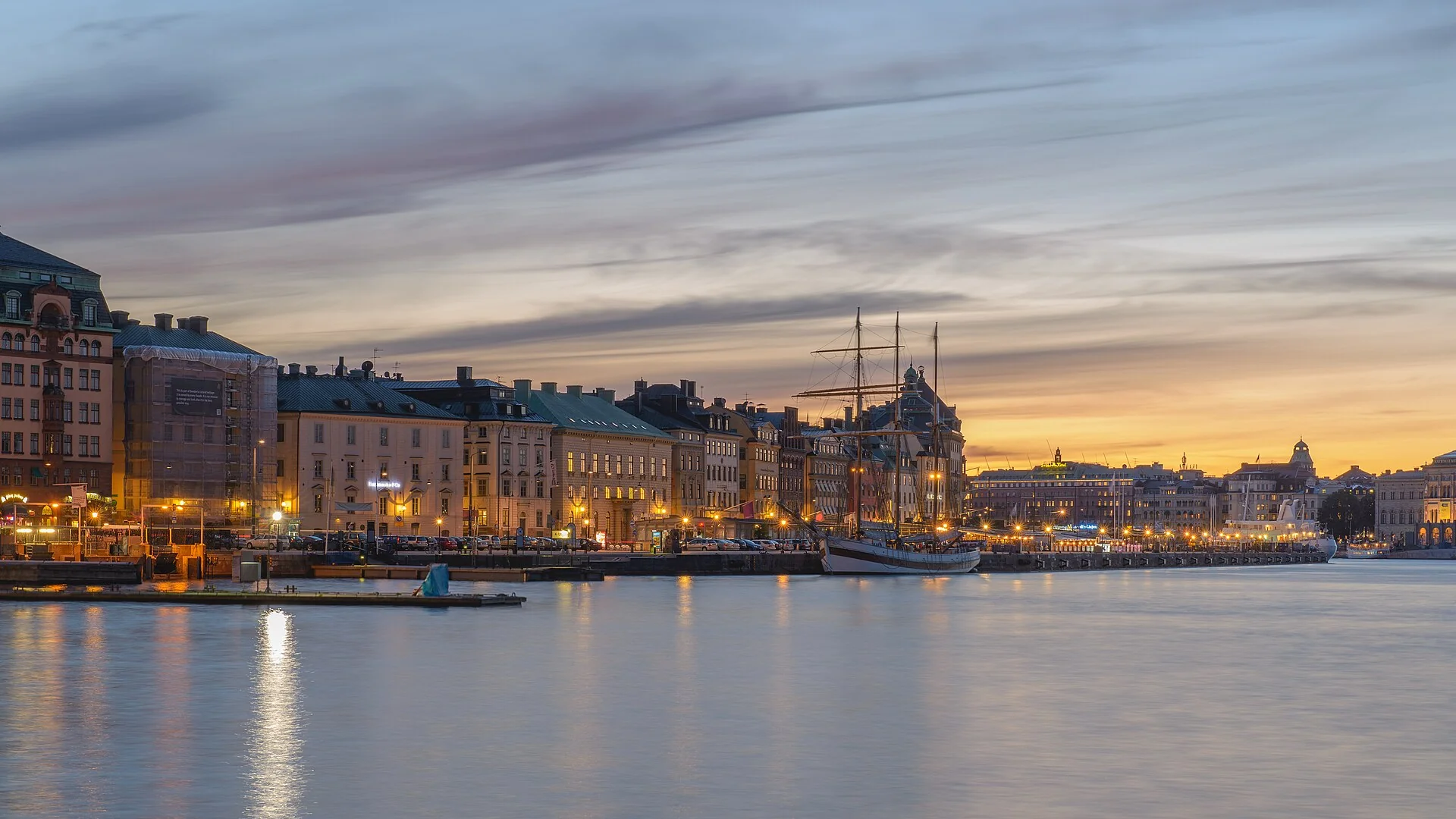
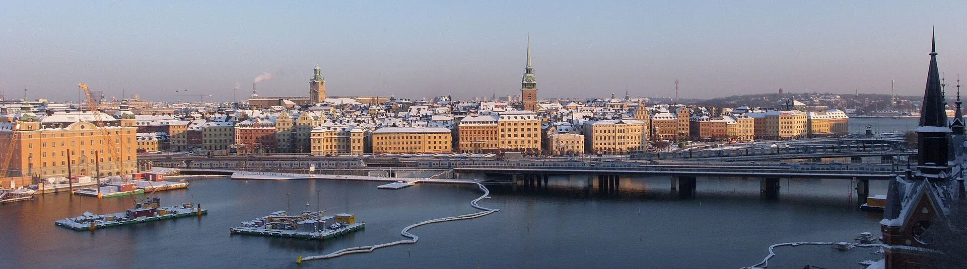
Skeppsbron seen across the water in June 2013 · Arild · CC BY-SA 2.0 · Resized and converted to WebP
Reading mode
Place stories to read at your own pace
Compare the wider setting, a closer subject and another season or date.
Chapter 1 · A room of colourful façades
Begin with the edges of Stortorget
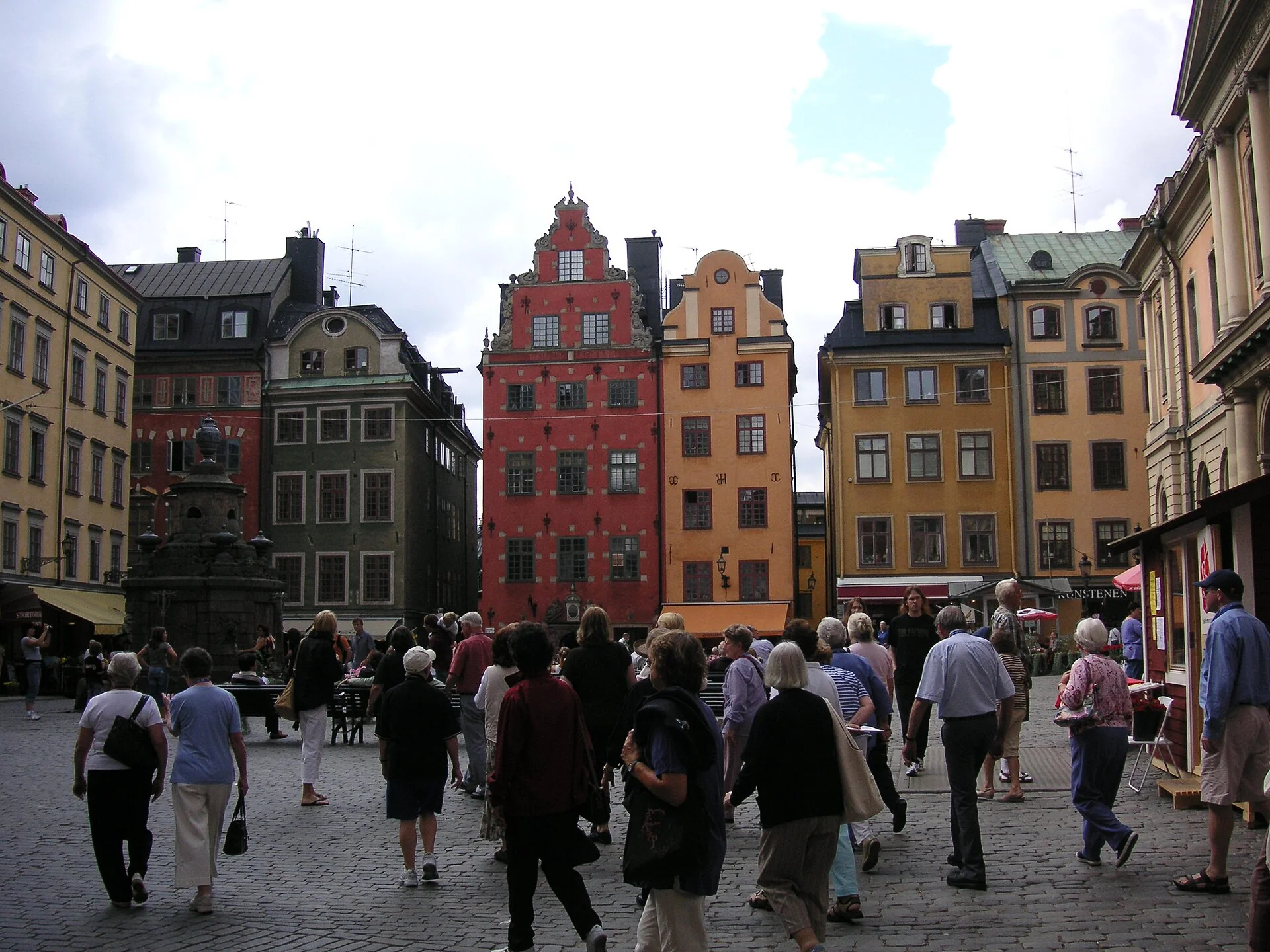
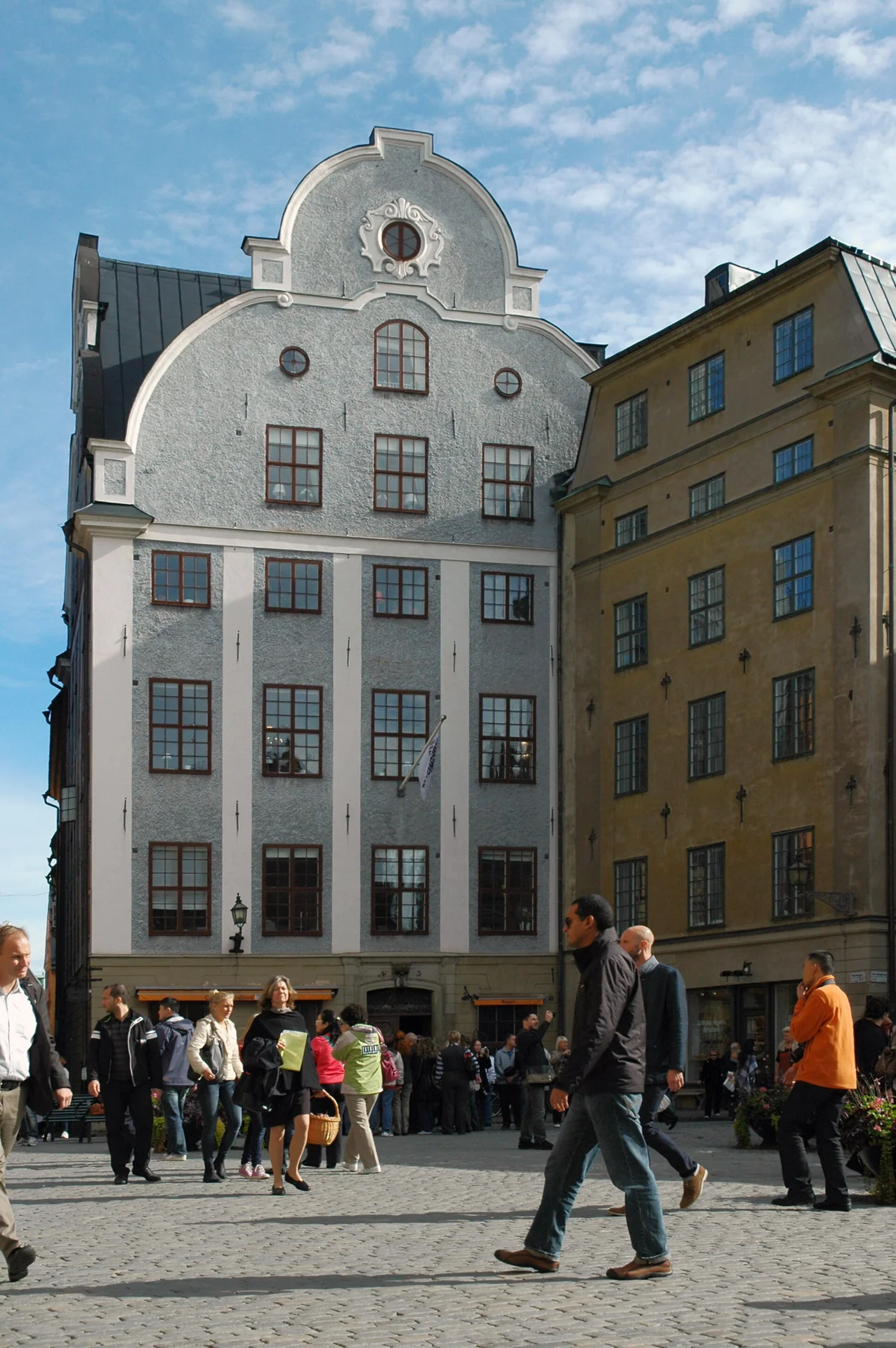
Stortorget is a useful place to slow down before exploring the lanes. Find the outlines of the façades first: one roof rises, another steps down, and windows form their own repeated pattern. The opening between buildings matters as much as any single coloured house. Visit Stockholm places Gamla Stan in the city’s earliest district; here the introduction is visual rather than a checklist of every historical event associated with the square.
The three photographs offer different ways to look. An August 2006 view establishes the square and its fountain-side setting. A September 2012 photograph isolates Grillska huset, while the November 2024 evening scene changes the light and includes seasonal decoration. That decoration belongs to the recorded date: it is not an announcement of a current Christmas market. Use the left and right controls to compare rooflines, doors and the space occupied by people. Separate photographs are not successive steps in one walk.
The checked September 2010 Google scene is look-around only, not an uninterrupted crossing to the cathedral. Neighbouring images did not reproduce a stable three-position chain, so no forward control is promised here. Turn around to compare the square’s different edges. Along-route exploration adds Prästgatan and other small lanes as separate experiences. Their older imagery can help explain enclosure and scale, but it cannot tell you how crowded, icy or accessible the paving is now. For a physical visit, keep entrances clear and use a current pedestrian map for connections.
Read further: Stockholm’s Stortorget: literature in the Exchange BuildingReal-travel note
September 2010 square panorama, look-around only. Evening decoration in the photograph is historical, not a current event schedule. Uneven paving and crowds require present-day judgement.
Compare the wider setting, a closer subject and another season or date.
Chapter 2 · A church within the streets
Find the cathedral between square and palace
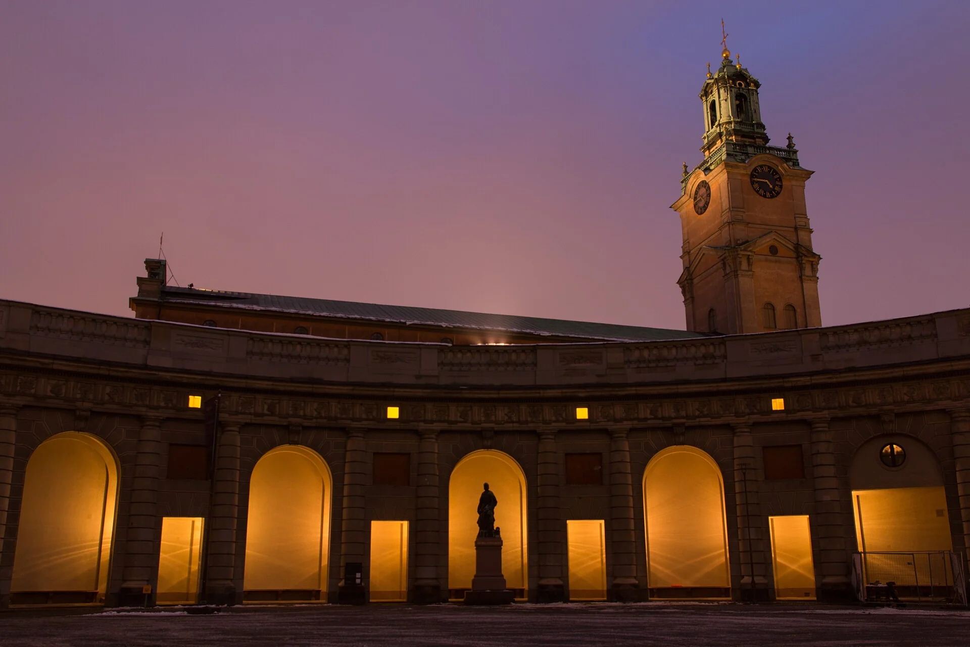
Storkyrkan does not need a vast empty foreground to make its presence felt. Its tower appears between the surrounding buildings, while the lower walls and doors belong to the scale of the lanes. Look up, then return your attention to the entrance. The church’s own visitor information locates the cathedral between Stortorget and the Royal Palace. That relationship is more useful here than trying to infer an indoor route from an exterior photograph.
Switch between a January 2015 evening view, a September 2006 doorway photograph and a January 2016 winter composition that places the cathedral beside the palace. The last is a wider contextual view, not a picture taken from the interactive camera position. The differing dates and light reveal how much a familiar building can change in appearance without changing location. Snow in a historical photograph does not describe today’s ground conditions, and an open doorway in a photograph is not permission or a promise of entry.
The optional Google interaction is a separate September 2014 interior fragment, with brick columns, seating and decorated fittings. Three checked positions allow a little movement and a return within that historical scene; they do not show entering through the photographed doorway or connect to the palace. Compare the feeling of enclosure inside with the exterior photographs. Worship, concerts and visits share a working religious space; consult the Church of Sweden’s current visitor page for access rather than treating the virtual scene as a timetable. The panorama is not an admission ticket, and its older furnishings or arrangements may differ today.
Real-travel note
Separate September 2014 historical interior, not a doorway-to-nave route. Virtual viewing does not establish current admission, services or a step-free connection.
Compare the wider setting, a closer subject and another season or date.
Chapter 3 · A different scale
Step back from the Royal Palace façade
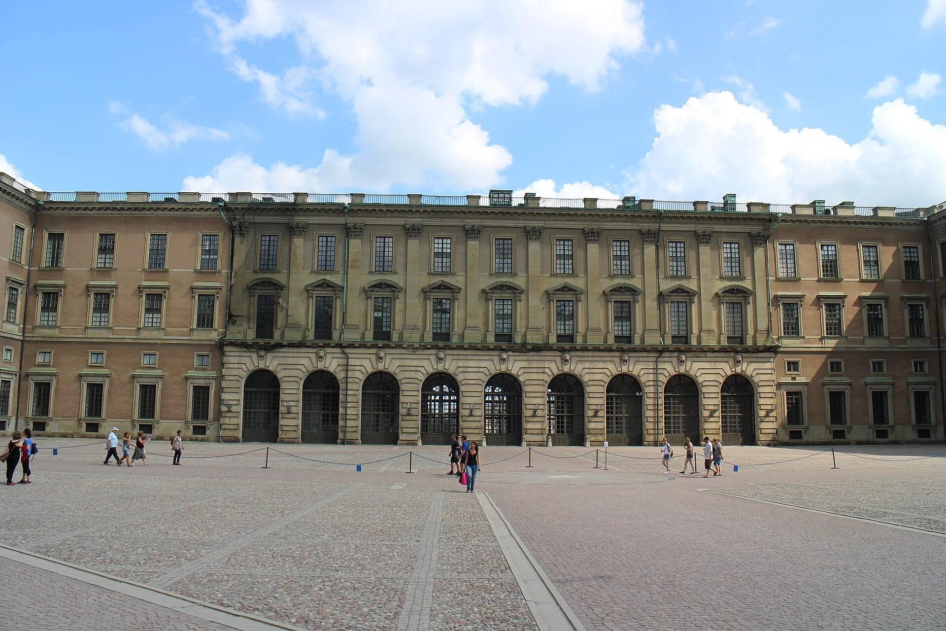
The Royal Palace changes the scale of the journey. Instead of several small façades, a long repeated frontage holds the view together. Count a few window bays, then look at the whole elevation again. The Royal Palaces’ official account describes a royal workplace and ceremonial setting as well as a visitor attraction. A guard or barrier is therefore part of an active place, not a prop in a static architectural view.
The July 2018 photographs show the outer courtyard-facing building and a separate waterfront elevation. The January 2016 photograph looks towards the palace from Slottsbacken and makes the entrance details easier to compare. These are independent observations; they do not describe walking through the building from one side to the other. A boat visible beside a waterfront photograph does not add a cruise or transfer to the route. Read the individual caption before assuming that two images share a camera position.
The reviewed interactive scene is outside, on the palace’s western approach. It does not enter the Royal Apartments, Treasury or Royal Armoury. An initially found nearby panorama was inside the Armoury and was excluded from this exterior experience. Turn towards the palace and compare its wall with the surrounding street space. For an actual visit, check the official calendar: working royal use can alter access, and neither old images nor this chapter guarantee a ceremony, a particular door being open or a current visiting time. Leave guards and entrances room and follow the arrangements on site.
Real-travel note
Outdoor palace approach, not an indoor museum sequence. Royal functions can change access; admission and guard ceremonies require current official information.
Compare the wider setting, a closer subject and another season or date.
Chapter 4 · The city opens to water
Compare Skeppsbron from near and far
At Skeppsbron, the close walls of the old town give way to an edge. Water extends one side of the view while buildings keep a repeated rhythm on the other. Begin by distinguishing the street, quay and water rather than assuming every open paved strip is a walking route. Traffic and service activity can belong to the same waterfront composition as attractive façades.
The June 2013 wide photograph was taken from across the water, not from the pavement used by the interactive camera. Its evening sky groups the façades into a skyline. The two September 2025 photographs identify Skeppsbron 44 and Skeppsbron 34 individually. Compare roof shapes, window spacing and ground-floor openings. Those two buildings are subjects along the wider waterfront, not a claim that the short interactive fragment reaches their entrances. A distant view is included to explain the setting, not to pretend the user crossed the harbour.
The July 2024 Google sequence is a small fragment near Brunnsgränd. Its three linked positions and return show a changing relationship between a narrow street and the waterfront edge. It is not a quay-length walk or a boat trip, and a road camera may occupy space where a pedestrian should not stand. Rotate to inspect the surroundings before moving; then return to the photo gallery to see the longer waterfront composition. For a real visit, use present-day crossings and permitted footways, keep away from unprotected water edges and check ferry or cruise arrangements independently. The onward chapter on Riddarholmen is an editorial jump, not a verified continuous connection.
Real-travel note
July 2024 Brunnsgränd-area fragment, not the entire waterfront. The wide photograph is across the water; no boat trip or through-route to Riddarholmen is included.
Compare the wider setting, a closer subject and another season or date.
Chapter 5 · A spire and a wider horizon
Finish beside Riddarholmen’s church and water
Riddarholmen offers a quieter change of scale at the end of the story. A church spire gives the eye a vertical reference, while the surrounding island and water make room for a much longer view. Visit Stockholm identifies the church as a surviving medieval abbey, and the Royal Palaces explain its role as a royal burial church. This chapter looks at its exterior setting rather than turning the building into a generic palace interior.
The December 2009 panoramic photograph places the island within an across-water winter view. A June 2013 photograph brings the church closer, and a January 2016 view changes the season and light again. The wider image was not taken from the church-side panorama position. Compare silhouette and setting without reading the photographs as one continuous approach. Winter colour, bare trees and distant buildings are records of those individual dates, not current weather or a promise of a clear skyline.
The September 2022 church-side Google scene is published as a look-around only. Some adjacent images exist, but the tested coordinate searches did not reproduce a reliable three-position chain, so the interface does not promise forward movement there. Along-route exploration separately offers a water-side scene near Wrangelska backen; turning across the water changes the emphasis from the church to the city horizon. These independent experiences do not enter the church or verify a complete island circuit. Check the Royal Palaces’ current opening and access pages before visiting, and independently assess cobbles, slopes, crossings and water edges. End by choosing which view deserves more time, not by treating historical imagery as live navigation.
Real-travel note
Church-side scene is look-around only; the water-edge fragment is a separate experience. Current church opening, admission and accessible connections are not established by these images.
10 reviewed experiences
Explore along the route
Step into the places along this journey. Choose a view independently of the story chapters. Free previews do not count toward chapter progress. Return to the journey above to continue through its stops.
Begin with the edges of Stortorget 360° look-around
September 2010 Stortorget panorama: look around only. Nearby links were not reproducible as a stable coordinate-resolved chain. It does not connect to the cathedral; the seasonal preview is from a different date.
Reviewed 2026-10-21 · At the place
Explore at your own pace; these views do not count toward chapter completion. Check each point's coverage note before navigating provider imagery. Availability may change.
Sources
- Börshuset — Swedish Academy
- About the Nobel Prize Museum — Nobel Prize Museum
- Gamla Stan / Old Town — Visit Stockholm
- Visiting Stockholm Cathedral — Church of Sweden
- The Royal Palace — The Royal Palaces
- Visit the Riddarholmen Church — The Royal Palaces
- The Riddarholmen Church — Visit Stockholm
- Börshuset 2010.JPG — I99pema · Wikimedia Commons
- Västerlånggatan Stockholm 2022-09-20 03.jpg — Leonhard Lenz · Wikimedia Commons
- Stortorget 2006.jpg — Holger Ellgaard · Wikimedia Commons
- Stortorget 3-5 (Grillska huset), Stockholm, 2012.jpg — DimiTalen · Wikimedia Commons
- Stockholm Gamla Stan Stortorget during Christmas.jpg — Tunegravity · Wikimedia Commons
- Storkyrkan, Stockholm (16201228438).jpg — Martin de Lusenet from Heemskerk, Netherlands · Wikimedia Commons
- Storkyrkan Stockholm portico jonez flickr.jpg — dennis and aimee jonez · Wikimedia Commons
- Storkyrkan and Kungliga slottet Stockholm 2016 01.jpg — Julian Herzog (Website) · Wikimedia Commons
- Exterior of the Royal Palace, Stockholm 20180731.jpg — Suicasmo · Wikimedia Commons
- Exterior of the Royal Palace, Stockholm 20180731-2.jpg — Suicasmo · Wikimedia Commons
- Kungliga slottet The Royal Palace Stockholm 2016 01.jpg — Julian Herzog (Website) · Wikimedia Commons
- Skeppsbron june 2013.jpg — Arild · Wikimedia Commons
- Skeppsbron 44 September 2025 01.jpg — ArildV · Wikimedia Commons
- Skeppsbron 34 September 2025 01.jpg — ArildV · Wikimedia Commons
- Stockholm Riddarholmskyrkan 3.JPG — Zairon · Wikimedia Commons
- Riddarholmskyrkan Stockholm 2016 01.jpg — Julian Herzog (Website) · Wikimedia Commons
- Monteliusvägen panorama 2009b.jpg — Holger.Ellgaard · Wikimedia Commons
- Mårten Trotzigs gränd - 20230930 - 13.jpg — AleWi · Wikimedia Commons
- Prästgatan October 2017 01.jpg — Arild Vågen · Wikimedia Commons
- Tyska skolgränd March 2025 01.jpg — ArildV · Wikimedia Commons
- Stockholm City Hall February 2014 01.jpg — Arild Vågen · Wikimedia Commons


Your journey, remembered.
Explored 0 of 5 stops. Explore every stop to unlock your keepsake.
5 stops to your keepsakeExplore every stop to share or download your keepsake.
Prepare an old-town visit
Use the visual journey to choose where to pause, then check current walking connections and entry independently.
Official sources checked:
Connect different city spaces
Suggested story order: Stortorget → cathedral → palace → Skeppsbron → Riddarholmen. Roughly 2–3 km and 2–3 outdoor hours are planning estimates, not a measured track. Narrow-lane detours and indoor visits take additional time. Use current pedestrian crossings; the chapter order is not turn-by-turn navigation.
Separate images from admission
The cathedral is an active religious space. The palace is also a workplace and reception venue; individual areas can close for official use. Riddarholmen Church has its own opening and access information. A historical interior panorama never establishes current entry or a ticket.
Choose safe ground, not camera positions
Cobbles, stairs in small lanes, slopes, winter ice and water edges need independent assessment. Leave working entrances, guards and residents room. Some cameras are in traffic space; do not copy their position. This route has not been verified as step-free.