
Arashiyama: from the river into the bamboo
A photo-led walking route through five sides of western Kyoto: bridge, temple garden, shrine, bamboo path and river overlook.
Explore 4 reviewed views along the routeGuided visual journey

Path among tall bamboo stalks in Arashiyama · Basile Morin · CC BY-SA 4.0
Reading mode
Place stories to read at your own pace
Chapter 1 · Across the water
The bridge that gives the valley its shape
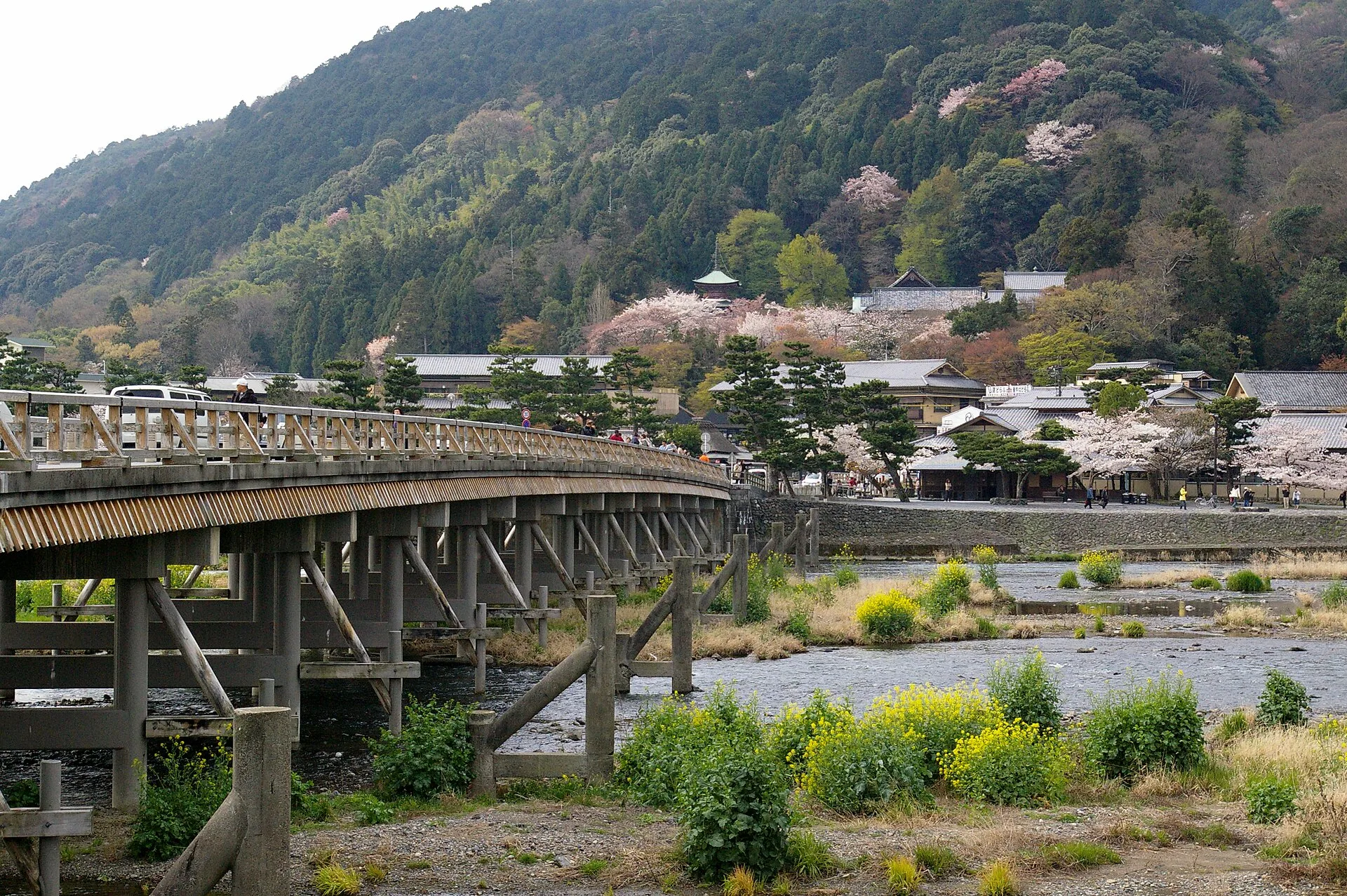
Before entering a garden or a bamboo corridor, look across the Katsura River. Togetsukyō draws a long horizontal line between the shops, water and the hillside. The spring photograph lets you read that relationship: the bridge is a crossing, not a viewing platform detached from the ordinary movement of vehicles and people. A second, darker image shows how much the same place changes with light. Neither frame establishes the water level or crossing conditions today.
Kyoto City's history places an early bridge here in the ninth century and says the current structure dates from 1934. It also recounts the tradition that Emperor Kameyama likened the moon moving over the bridge to a moon crossing the sky, giving “Togetsukyō” its poetic name. Treat that as the place's naming story, not photographic evidence about the original span. The structure you will meet is modern in date, while the setting and its remembered stories reach much farther back.
This is also where the day can branch. You could stay by the river, cross toward the opposite bank, or turn into the temple and bamboo area on this side. Our five stops take that last editorial order; they are not a surveyed turn-by-turn route. The optional Google panorama is a single look-around point near the bridge. Its nearby street-view arrows, if any, do not certify a walk to Tenryū-ji. Check live crossings and give others room to move before choosing where to go next.
Real-travel note
The bridge serves real local traffic. Check current crossings and riverside access; do not stop in the middle of the crossing for a photo.
Chapter 2 · Garden and mountain
A pond that holds the hills
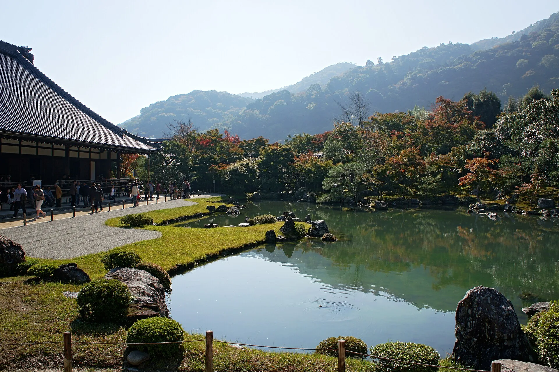
The sound and scale change inside Tenryū-ji. In the first photograph, the pond opens beside a temple building while the wooded slopes complete the view. The second photograph comes closer to water, trees and stones. Compare them rather than hunting for a single “best angle”: one explains the garden's relationship to the mountain, the other asks you to notice its smaller composition. Both are dated records, and neither promises the same foliage or visiting arrangements now.
The temple's own account dates its founding to 1339, when Ashikaga Takauji established it in memory of Emperor Go-Daigo; Musō Soseki was its founding abbot. The temple describes Sōgen Pond Garden as a central feature of the precinct. Its explanation of the garden includes a dragon-gate image in which a carp becomes a dragon after clearing a waterfall. That is symbolic garden interpretation, not a claim that a particular fish in this photograph performed a miracle. The history makes the still water more interesting than a decorative backdrop to a travel selfie.
Allow this stop to stand on its own. Temple access and garden admission are governed by the temple, and the exact hours and fee can change: check the official visitor page before travelling. The optional 2010 Google panorama was reviewed in a temple courtyard, not at the photographed pond. It may help with spatial orientation, but it cannot replace the garden photographs or prove a continuous path to Nonomiya Shrine. From here our story changes scene, with an editorial jump rather than a filmed walk.
Real-travel note
Check Tenryū-ji’s current garden opening and admission on its official site. Keep to permitted paths and allow space for other visitors.
Chapter 3 · A quieter threshold
The black gate of Nonomiya
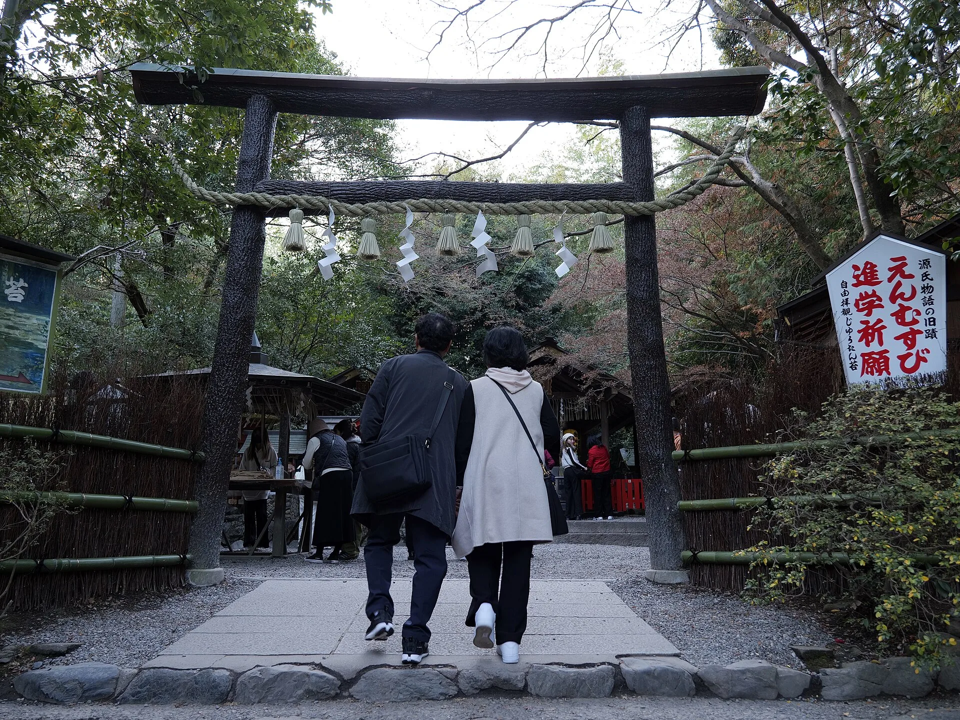
The next two photographs both show a black wooden torii, but from different distances and in different years. The closer frame makes its dark timber and rope visible; the older approach photograph includes people arriving along the path. Together they show Nonomiya as a small lived-in shrine rather than a stage prop placed beside the bamboo grove. Visitors may be praying, and the entrance is not an invitation to block the way for a portrait.
Kyoto City's account connects Nonomiya with the Saiō, women of the imperial family who prepared for service at Ise. It names the black-wood torii and brushwood fence as characteristics of the site. Another Kyoto City guide links it with the “Sakaki” chapter of The Tale of Genji. This is literary and religious context that visitors can carry into the scene; it does not mean the people or precise structures in a modern photograph appeared unchanged in the classical period. The real distinction is that a brief threshold can hold several layers of memory.
We intentionally do not offer a 360° scene here. A nearby Google result showed the adjacent street and sign, not a convincing view of this torii and inner approach. Substituting it would make the interaction feel richer while actually showing less of the place. Use the two licensed photographs instead, and if you visit, follow posted shrine guidance, step aside for worshippers and consider whether photographs are appropriate where people are praying. The next scene enters the bamboo path; it is a separate image stop, not footage of your departure from the shrine.
Real-travel note
This is a shrine, not only a photo stop. Respect worshippers and any posted photography restrictions; do not block the entrance.
Chapter 4 · Among the stalks
What the bamboo path really feels like
The bamboo is the image many travellers already carry in their heads. Here, the first photograph gives the path its proper scale: tall, closely spaced stalks frame a real walkway. The second moves attention toward the trunks and changing light. Neither photograph is a live crowd indicator. Kyoto's official visitor guidance warns that Arashiyama is a busy sightseeing area, so an empty-looking frame should not become a promise of solitude. Look at the proportions, texture and path surface instead of expecting a private forest.
This is the one stop where our imagery audit found a short, genuinely place-matched moving 360° segment. The March 2025 Google capture begins on the western part of the bamboo route. Adjacent linked frames from the same capture were checked; the scene shows bamboo and the path, not the cemetery-side fence returned by another candidate coordinate nearby. The movement is bounded to those few frames. It does not cover the full grove, it does not connect the shrine or the park, and availability may change when Google refreshes its imagery.
The distinction matters because “360°” is not the same as “walk anywhere.” You can turn your view at many panoramas, but only connected, reviewed frames support honest forward movement. Try the short section if it loads, then return to the photographs and notes for the rest. On a real visit, stay on public paths, follow signs and keep moving where the route narrows. The next chapter is a visual jump to Kameyama Park's river side, not a recorded continuation of this bamboo sequence.
Real-travel note
Crowds vary by time and season. Stay on the public path and check current local guidance; the optional panorama is only a short historical capture.
Chapter 5 · Back to the river
Let the valley be the ending
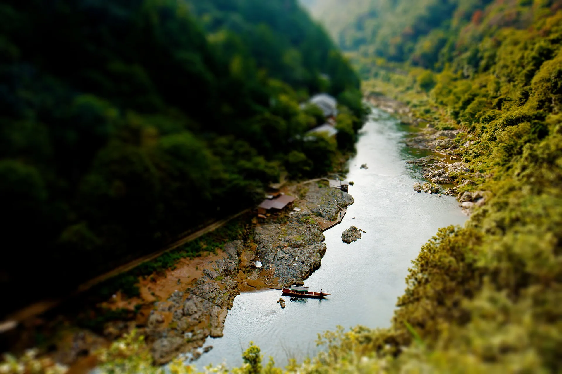
After the enclosed bamboo path, the landscape can open again. The first image was taken from near the riverside outlook and looks down the Hozu River gorge, with a boat as a small point of scale. The file's camera location lies by Kameyama Park. Its selective-focus blur is part of the original photograph, not a representation of how the scene appears to the eye. The second image is deliberately different: a red maple canopy identified as Kameyama Park, a seasonal detail rather than another river panorama. The two images are not a matched pair from one visit.
Kyoto City's guide points visitors to the observatory in Arashiyama Park's Kameyama area. That is a good reason to end here: the river returns from the opening bridge scene, but seen from above and farther into the hills. A reviewed 2017 Google panorama at the overlook shows the railing, trees and river side. It is an isolated point with no verified onward links. It does not prove which park paths are open today or how to return to a station; use live signs and a current map for that.
You do not need to collect every landmark to get something from this route. The bridge gave you a broad setting, Tenryū-ji a designed landscape, Nonomiya a sacred threshold, the grove a tightly framed path, and this park a place to compare them. Each chapter was photographed in a different year. If you now want to go in person, choose the stops that matter to you, check garden access and daylight, and leave enough time for the walk back. If the destination feels too crowded or too staged, that is a useful travel decision too.
Real-travel note
The riverside viewpoint is not a live safety report. Check current park paths, daylight and return route; do not assume the boat in the old image operates today.
4 reviewed experiences
Explore along the route
Step into the places along this journey. Choose a view independently of the story chapters.
Explore at your own pace; these views do not count toward chapter completion. Short sequences cover only the reviewed section. Imagery availability may change.
Sources
- Saga-Arashiyama — Kyoto City Official Travel Guide
- Togetsukyo Bridge — Kyoto City Official Travel Guide
- 渡月橋 — Kyoto City Tourism
- About Tenryū-ji — Tenryū-ji
- Temple Precincts — Tenryū-ji
- Visitor information — Tenryū-ji
- 野宮神社 — Kyoto City Tourism
- 野宮神社 — Kyoto City School Trip Guide
- Things to keep in mind while exploring Kyoto — Kyoto City Official Travel Guide
- Arashiyama Togetsukyo-bridge.jpg — Wikimedia Commons
- Togetsukyo Bridge and Mount Arashiyama.JPG — Wikimedia Commons
- Tenryuji Kyoto01n4500.jpg — Wikimedia Commons
- Tenryu-ji Zen Pond.jpg — Wikimedia Commons
- Nonomiya-jinja (Ukyō-ku Kyoto) Black Torii hdsr S5 07.jpg — Wikimedia Commons
- Nonomiya Shrine, Sagano, Kyoto - Feb 10, 2013.jpg — Wikimedia Commons
- Bamboo Grove, Arashiyama, Kyoto, Japan.jpg — Wikimedia Commons
- Arashiyama Bamboo Grove.jpg — Wikimedia Commons
- Arashiyama Hozu River - panoramio.jpg — Wikimedia Commons
- Kameyama Park (2700618442).jpg — Wikimedia Commons


_Black_Torii_hdsr_S5_07.jpg)


.jpg)
Your journey, remembered.
The keepsake unlocks when you reach this section.