
West Lake, Hangzhou: from Broken Bridge across Bai Causeway to Gushan
Follow this West Lake walking route from Broken Bridge, along Bai Causeway, to Pinghu Qiuyue, Zhongshan Park and Gushan.
Guided visual journey
Reading mode
Place stories to read at your own pace
Chapter 1 · The arch at the east end
Broken Bridge, where the causeway begins
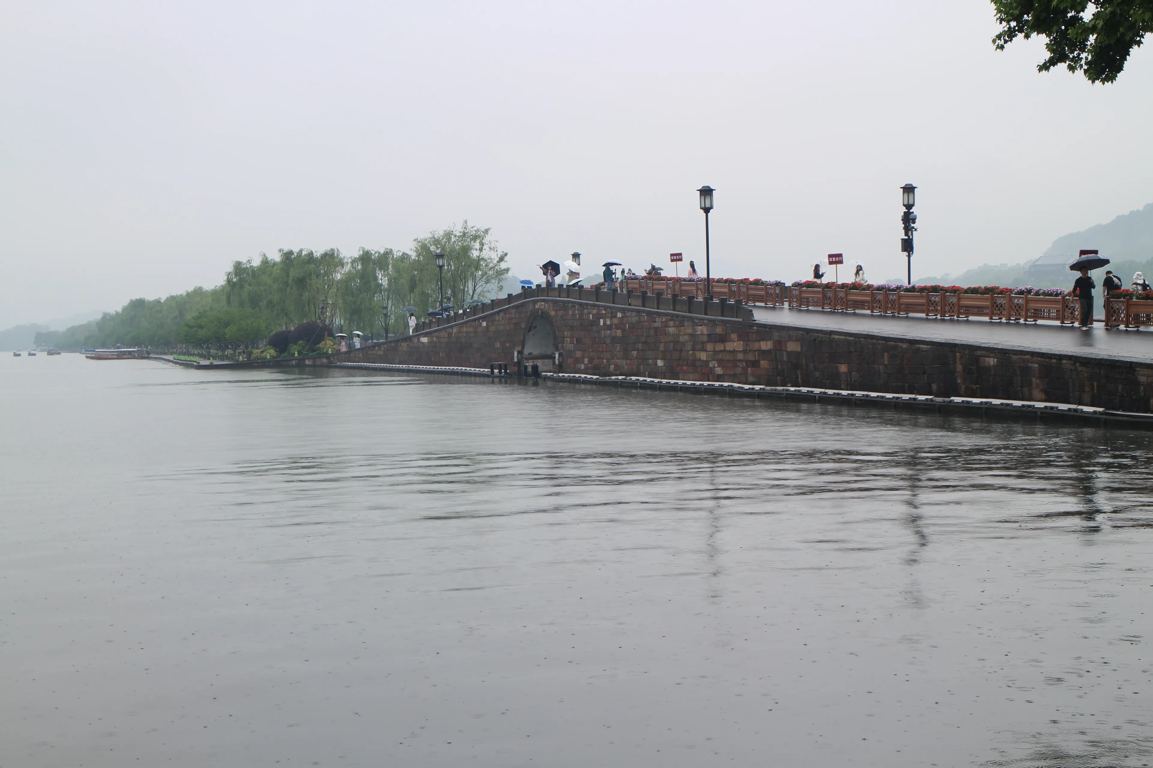
Begin at the east end of the single stone arch, where the northeast shore meets the causeway. The Hangzhou culture and tourism bureau’s 12 April 2022 account places Lingering Snow on the Broken Bridge, one of the Ten Scenes named in the Southern Song, at this east end of Bai Causeway. The causeway runs east–west and splits the lake into a southern part and a northern part, so the arch is one of the few places where both waters sit in the same glance. The bureau gives the present bridge as a semicircular stone arch with a sloping asphalt deck, 8.8 metres long, 8.6 metres wide and 6.1 metres in clear span. A later bureau page, published on 1 December 2023, uses those same dimensions for a 1921 rebuild and says the bridge you meet was altered in 1941 and finished again in the 1950s. The two pages are the bureau’s own record. They are not a claim that every stone dates from one year.
The photograph is that arch on the morning of 5 May 2025, at 08:21, in rain. People on the deck are carrying umbrellas. Willows continue west, which is the causeway you are about to walk. The file has no GPS. The identification is the single stone arch and that willow line, checked against a 29 June 2023 photograph of the same arch taken from the lotus side. Lingering Snow is the old scene name. The 2022 page treats the popular explanation as a story about snow: after a clear spell, the sunny half of the deck melts and the white line looks broken. A rainy May morning is not that scene. Snow is not part of the ticket, and it is not waiting on the bridge.
Two other stories sit beside the masonry, and they are not the same kind of sentence. One naming account, given by the bureau as a tradition, says the bridge was once the Duan family bridge and later called Broken Bridge because the words sounded alike. The White Snake is named by the bureau as one of China’s four great folk legends, with important episodes set here. The December 2023 page adds the tradition that this is where Bai Suzhen and Xu Xian pledged themselves. That is legend. It is not a dated construction record, and it does not change the span of the arch.
A stele pavilion stands off the east end. The 2022 page says the Kangxi inscription of the scene name dates from his 1699 visit, the stone was set up in 1702, and the present stone was recut in 1977 to the old size and hand. This chapter stays on the arch. The next step is west, onto the causeway, with water on both sides and the hill still ahead.
Real-travel note
The bureau’s Broken Bridge page, read on 28 September 2026, lists the viewpoint as open all day and prints a phone, 0571-87996663. It does not print an admission price. The deck is a slope. Recheck the day’s notice before you treat the shore path as open, and do not come for snow unless a forecast actually says so.
Chapter 2 · Water on both sides
Bai Causeway, leaving the arch
A short step off the arch puts you on Bai Causeway. The 2022 bureau page says this bank was already, in the Tang, the only link between Gushan and the shore, and that Song and Ming kept using it. Its older name was Baisha Causeway. From the Qing, the bank was renamed in memory of Bai Juyi, the Tang poet who served as prefect of Hangzhou. The page does not say he built the causeway you are walking. The name is a commemoration. The masonry and the planting are a later, measured bank: 987 metres long and 33 metres wide, with a 9-metre asphalt strip in the middle, stone footpaths along the water, peach and willow planted in turn, and a rough stone edge.
UNESCO’s inscription of the West Lake landscape, in 2011, describes the lake’s two causeways and three islands as the main artificial elements, formed by repeated dredging between the 9th and 12th centuries. That is a sentence about the lake’s made ground. It is not a sentence that Bai Juyi laid this pavement, and it should not be folded into the Qing renaming. What you can see is the idea those texts share: a thin line of made ground used to set up a view, with hills on three sides and the city on the fourth.
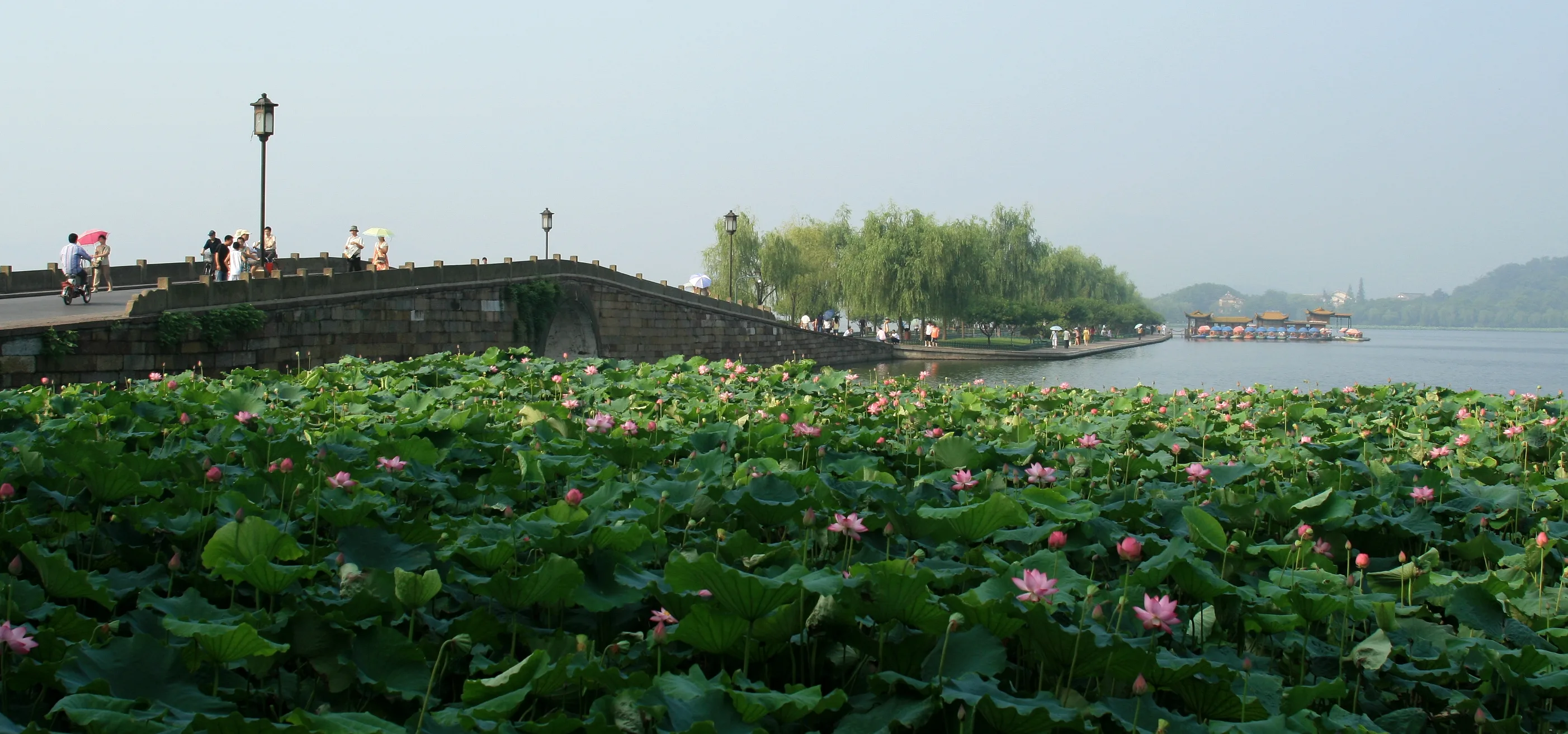
The photograph was taken at 07:58 on 14 July 2008. The camera coordinates on the file page are 30.260768 N, 120.146901 E, on the lotus side, about 76 metres from this chapter’s mapped point, looking along the causeway as it leaves the arch. Willows, a lamp, and a low stone wall run toward open water. Lotus covers the foreground. That is a July morning. It is not the peach season, and it is not the snow scene of the chapter you just left. The people on the deck are small in the frame. They are visitors on a path, not a measure of how busy the bank will be when you go.
The mapped line stays on the pedestrian causeway. On 28 September 2026 those ways were tagged in OpenStreetMap with motor vehicles and bicycles both set to no. A tag is not a warden. The bureau’s width includes the asphalt middle and the stone edges; the line you are following is the walking way, not a ferry and not a cut straight across the water. Jindai Bridge is the small arch in the middle of this bank. It is part of this leg, not a separate stop. The west end of the same bank is the lakeside platform.
Real-travel note
The causeway is open to the sky. Willows in the picture are not a roof. The July lotuses are that morning in 2008, not the planting you will meet. Recheck heat, rain and any path notice before you go.
Chapter 3 · The lake opens
Pinghu Qiuyue, off the end of the bank
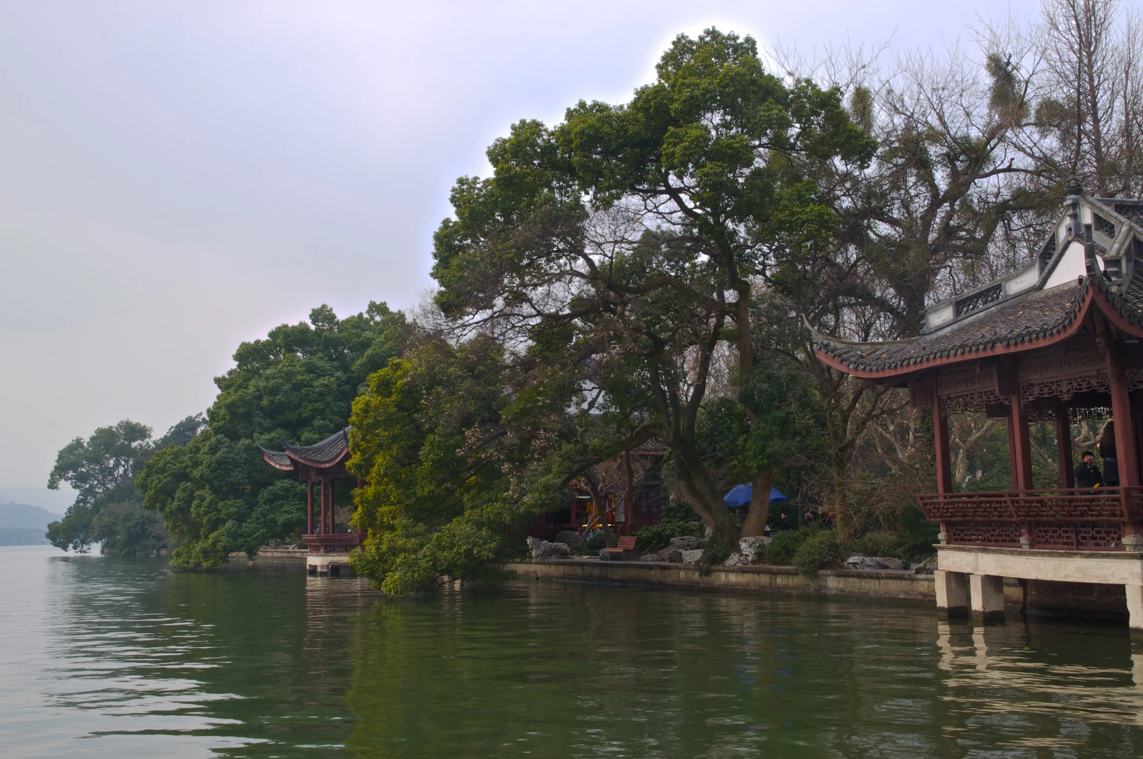
The causeway’s west end does not drop you into the hill. It brings you to a lakeside platform a short step south of the walking line. This is Pinghu Qiuyue, Autumn Moon over the Calm Lake, another of the Ten Scenes. The name is a picture: a level lake and an autumn moon. The place is a platform and a run of pavilions pushed out over the southern water, with the trees of Gushan behind them. You have left the long, even bank. The view is no longer a corridor of willows. It is the open lake, and the city is no longer the thing in front of you if you look south.
The photograph is that platform at 11:28 on 25 December 2010. The camera’s GPS is on the platform, about 20 metres from the mapped viewpoint, facing a little south of east along the shore. The frame is daylight under cloud. It is not a moon, and it is not autumn. December water and a quiet pavilion are one morning. They are not the Mid-Autumn crowd, and they are not a forecast. UNESCO dates the habit of naming ten poetic views to the Southern Song, the thirteenth century, and says those views were meant to hold a composed meeting of people and landscape. This platform is one of those composed edges: a floor over the water so that the lake can be looked at as a picture. The causeway you walked is the approach. The platform is the stop.
The mapped point stays at the viewpoint on the public edge. The gold line reaches it along Bai Causeway and does not draw a boat. A boat in any lake picture is traffic on the water, not the path. From here the walk leaves the causeway. Gushan Road runs along the south foot of the hill, and the park gate is that way, inland from the platform.
Real-travel note
The scene name promises an autumn moon. This photograph is 25 December 2010 in daylight. Recheck the hour and the weather if you are coming for the moon, and do not read a winter morning as the condition of the platform.

Chapter 4 · The garden on the hill
Zhongshan Park, the gate on Gushan
Gushan Road takes you off the causeway and along the south foot of the hill. The gate in the photograph is the arrival. A plaque over the door reads Zhongshan Park. Stone lions sit to either side, and a short flight of steps lifts the threshold off the wet road. This is no longer the flat bank. You are on Gushan, the hill the causeway was built to reach.
The Hangzhou Archives page, published on 6 May 2008, describes Gushan as the largest island in the lake, 38 metres high, standing between the inner and outer lake. It says Southern Song and Qing imperial gardens once covered most of the hill, and that in 1927 the garden was renamed Zhongshan Park in memory of Sun Yat-sen. The park is that garden, opened onto the public hill. It is not a separate island west of Gushan, and it is not the causeway continued under another name. The Xiling Seal Society, which the same archive page places on the summit, is a further place. This walk does not enter it, and it does not treat a 2008 count of objects there as a current inventory.
The photograph is the gate at 08:40 on 5 May 2025, nineteen minutes after the bridge picture in the same morning’s rain. The file has no GPS. The plaque is the identification. The mapped point is where the pedestrian route arrives on the south slope, on the approach to the grounds. Do not read the coordinate as the camera’s unrecorded position. The steps in the frame are the change from the causeway: a level lake path has become a threshold. Beyond the door the hill continues, and the last chapter is that climb, not another waterside pavilion.
Real-travel note
The Broken Bridge page’s all-day note was not copied onto this gate. On 28 September 2026 the pages read for this walk did not print a current admission price or a closing hour for the park. The photograph shows steps. Recheck at the door before you go in.
Chapter 5 · The hill itself
Gushan, where the walk stops on the hill
From the park grounds the path turns uphill. The last mapped stretch is about 200 metres of unnamed footway, climbing north onto the hill rather than continuing west along the shore. There is no street name on that segment. It is the moment the walk stops being a lake edge and becomes a hill. The Hangzhou Archives page puts the height of Gushan at 38 metres and calls it the largest island, between the inner and outer lake. You are already on it when you pass the park gate. This chapter is the climb that makes the hill legible.
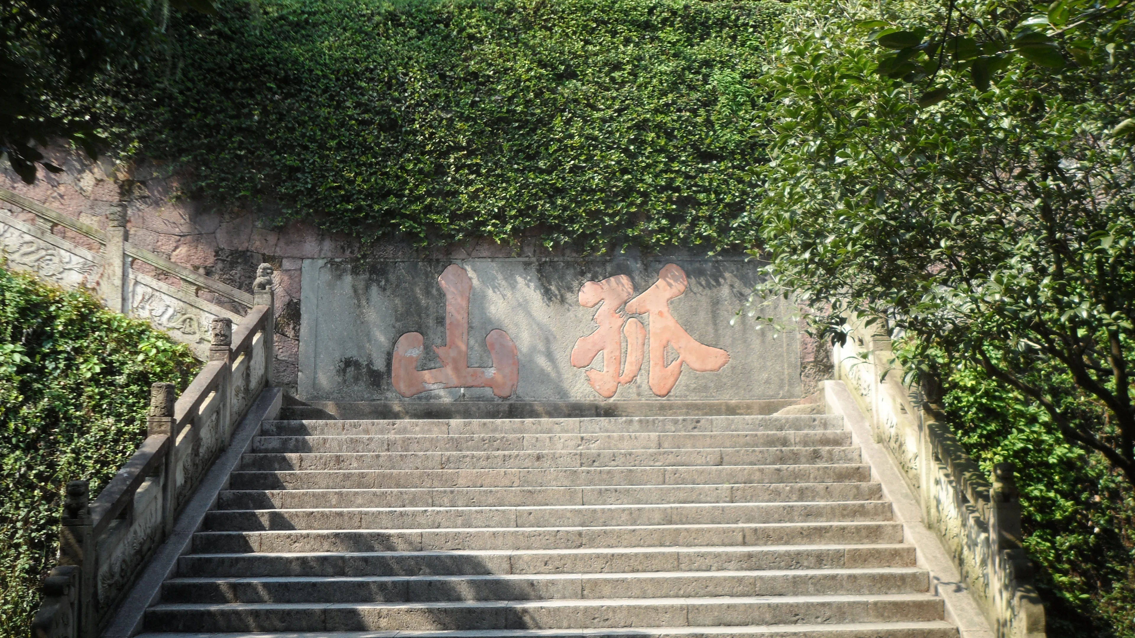
The photograph is a stone stair on 25 January 2011, at 05:55 by the camera clock. The wall at the top of the flight is lettered 孤山, Gushan, read in the old right-to-left order. That inscription is how the picture is tied to the hill. The file has no GPS, so the gold line is not a survey of this exact step. It is the pedestrian path from the park up to the hill label. If you need the stair itself, follow the characters, not an assumption that the line was drawn through them.
UNESCO describes a lake held by cloud-capped hills on three sides and by the city on the fourth, improved with causeways, islands, bridges and pavilions so that views could be composed. The walk you have made is one of those compositions in sequence: an arch that looks both ways, a willow bank with water on either side, a platform pushed over the open lake, a garden gate on the hill, and then the climb onto the hill. The stair in the photograph is lettered with the hill’s name, but the file has no GPS, so it is not evidence that the line passes through that step. The city skyline, when it appears, is the fourth side. It is not a mistake in the picture.
This journey stops on the hill. Xiling Bridge continues west from Gushan Road to the north shore, and it is a real way out, but it is not drawn here. Going back is the causeway in reverse, to the northeast shore where you began. The seal society on the summit, the museum rooms and any boat are other visits. They are not required to have walked from the arch to the hill.
Real-travel note
The stair is steps. The 2008 archives page is the source for the hill’s height, not a 2026 survey of railings or hours. This walk does not cross Xiling Bridge. Recheck the path and the day’s weather before you climb.
Sources
- West Lake Cultural Landscape of Hangzhou — UNESCO World Heritage Centre
- 西湖十景之断桥残雪 — 杭州市文化广电旅游局
- 斷橋(斷橋殘雪) — 杭州市文化广电旅游局
- 孤山风景 — 杭州市档案馆
- 断桥 — OpenStreetMap
- 白堤 — OpenStreetMap
- 平湖秋月 — OpenStreetMap
- 孤山路 — OpenStreetMap
- 孤山 — OpenStreetMap
- Broken Bridge (Hangzhou) 20250505 — Wikimedia Commons
- 杭州. 西湖. 断桥(白堤) - panoramio — Wikimedia Commons
- Autumn Moon Over the Calm Lake DSC 6192 — Wikimedia Commons
- Zhongshan Park (Hangzhou) 20250505 — Wikimedia Commons
- Gushan — Wikimedia Commons
_20250505.jpg)

.jpg)
_20250505.jpg)

Your journey, remembered.
The keepsake unlocks when you reach this section.