
Bangkok Old City: from the palace precinct to the flower market and river
Follow this Bangkok Old City walking route along public streets from the palace lawn to Wat Pho, Tha Tien, the flower market and the riverbank by Memorial Bridge.
Guided visual journey
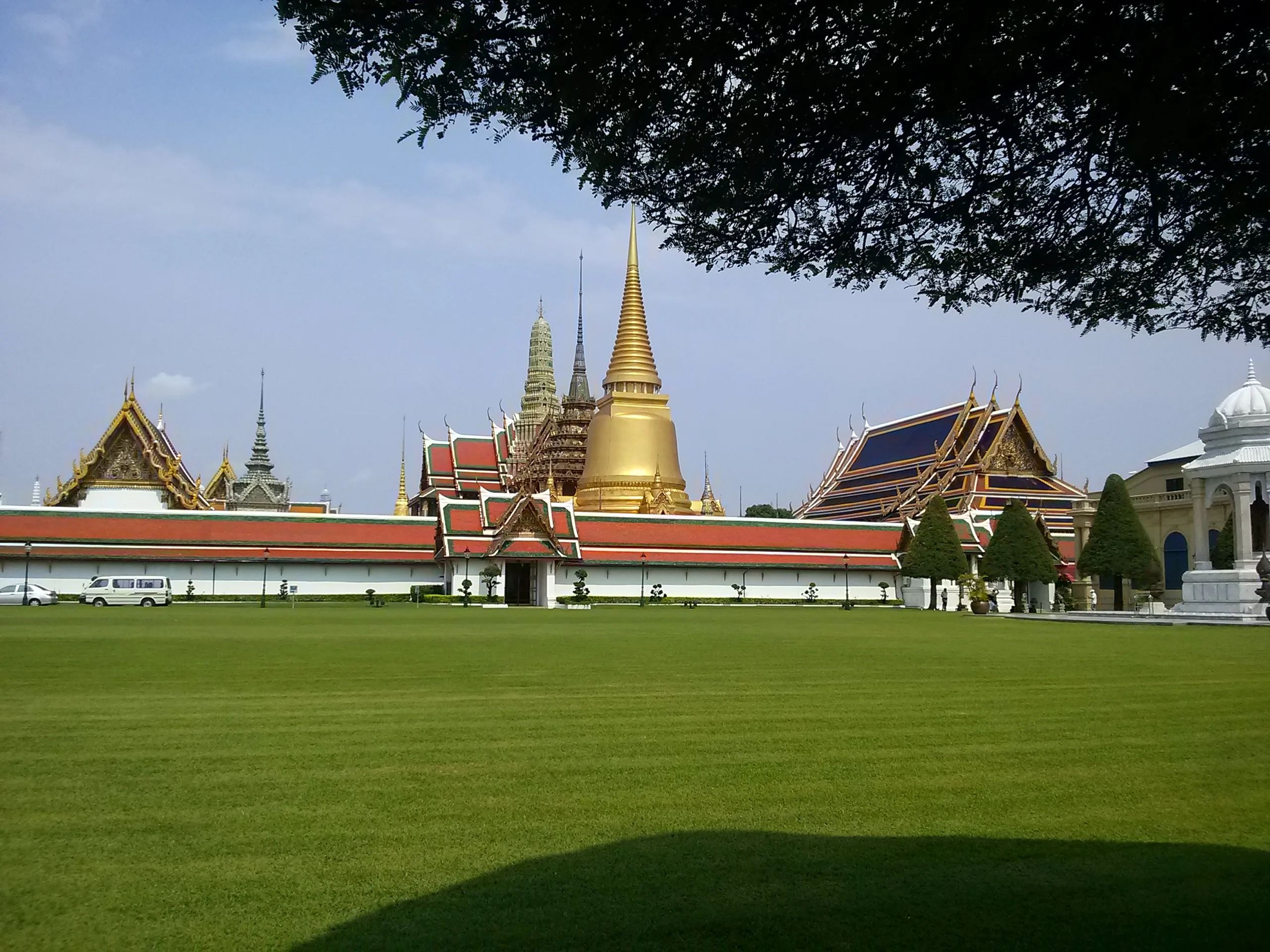
The white outer wall of the Grand Palace seen across the lawn, with golden roofs behind it · song songroov · CC BY 3.0
Reading mode
Place stories to read at your own pace
Chapter 1 · Before the gate
The palace lawn and the outer wall
Begin on the open lawn in front of the Grand Palace, on Na Phra Lan Road. A long white wall runs across the grass. Behind it, golden roofs and a tall chedi catch the light. Cars still use the road. This is city space, not a courtyard. You can stand here, look at the wall, and decide whether the interior is worth the ticket, the queue and the dress rules.
The lawn is the start of this walk. It is not the visitor entrance. On 10 January 2024 the Bureau of the Royal Household moved the entrance of the Grand Palace and the Temple of the Emerald Buddha from Viset Chaisri Gate to Mani Noppharat Gate. Viset Chaisri, also spelled Wiset Chaisri, is the north gate in front of this lawn. Mani Noppharat is another gate on the same outer wall, about 150 metres to the east. A map label still calls Viset Chaisri the main entrance. That label is out of date against the palace FAQ. If you are going in, walk east to Mani Noppharat and use the gate the palace names. Do not treat the north gate in front of you as the ticket gate.
The courts, the emerald Buddha and the rooms that stay closed to visitors are a separate visit. This route does not enter either gate. If you go in, you come back out to the street before the walk continues. The official pages still disagree about the clock: one block ends the day at 4:30pm and another at 3:30pm, with the foreigner ticket listed at 500 baht. Dress is stricter than “shoulders covered.” Recheck the notice at Mani Noppharat before you pay. A booth near the entrance can lend covering clothes. That is a help, not a reason to arrive unprepared in the heat.
From here the walk does not enter a gate. It turns west along Na Phra Lan and then south on Maharat Road, with the wall on your left and the river off to the right. The next stop is the street beside Wat Pho.
Real-travel note
The lawn is public. The palace interior is ticketed, and the official pages disagreed on 26 September 2026 about whether the day ends at 3:30pm or 4:30pm. Recheck the gate notice, the price and the dress rules before you pay.

Chapter 2 · The hall from the street
Wat Pho, from Maharat Road
Maharat Road brings you along the outside of the old city to Wat Pho. The building you meet first is the long hall of the reclining Buddha: a high roof, a white colonnade, and a wall between you and the statue. Taxis idle. A gate in the wall is the choice, not the path this walk is already on.
Wat Pho’s own pages place the temple on Sanam Chai Road and Maharat Road, next to the palace. They ask you to treat it as a place where religious life continues. Shoes come off before the buildings. Women are asked to stay out of the areas set aside for monks. A photograph of the hall from the street is the honest view of this chapter. The statue inside is why many people buy a ticket. It is not a corridor you can use to skip the streets.
The published details do not sit still. On 26 September 2026 the visit-plan page listed 8:00am to 7:30pm and 300 baht, with free entry for children under 120 centimetres, and asked visitors not to wear shorts. The home page listed a working time of 8:30am to 7:30pm, the same 300 baht, free entry for Thai visitors with a national ID, and advised women not to wear shorts above the knee. Those are two clocks and two ways of stating the dress rule. Recheck both at the gate rather than treating either page as permanent.
If you do go in, give the temple time and then come back to the street. The mapped line never crosses the compound. It stays on Maharat Road and turns toward the river. The next few minutes are the pier, not the interior of the hall.
Real-travel note
The street is public. The temple is ticketed. On 26 September 2026 the plan page said 8:00am and the home page said 8:30am. Recheck hours, the 300-baht notice and the dress rule before you enter.
Chapter 3 · A working landing
Yellow shophouses before Tha Tien
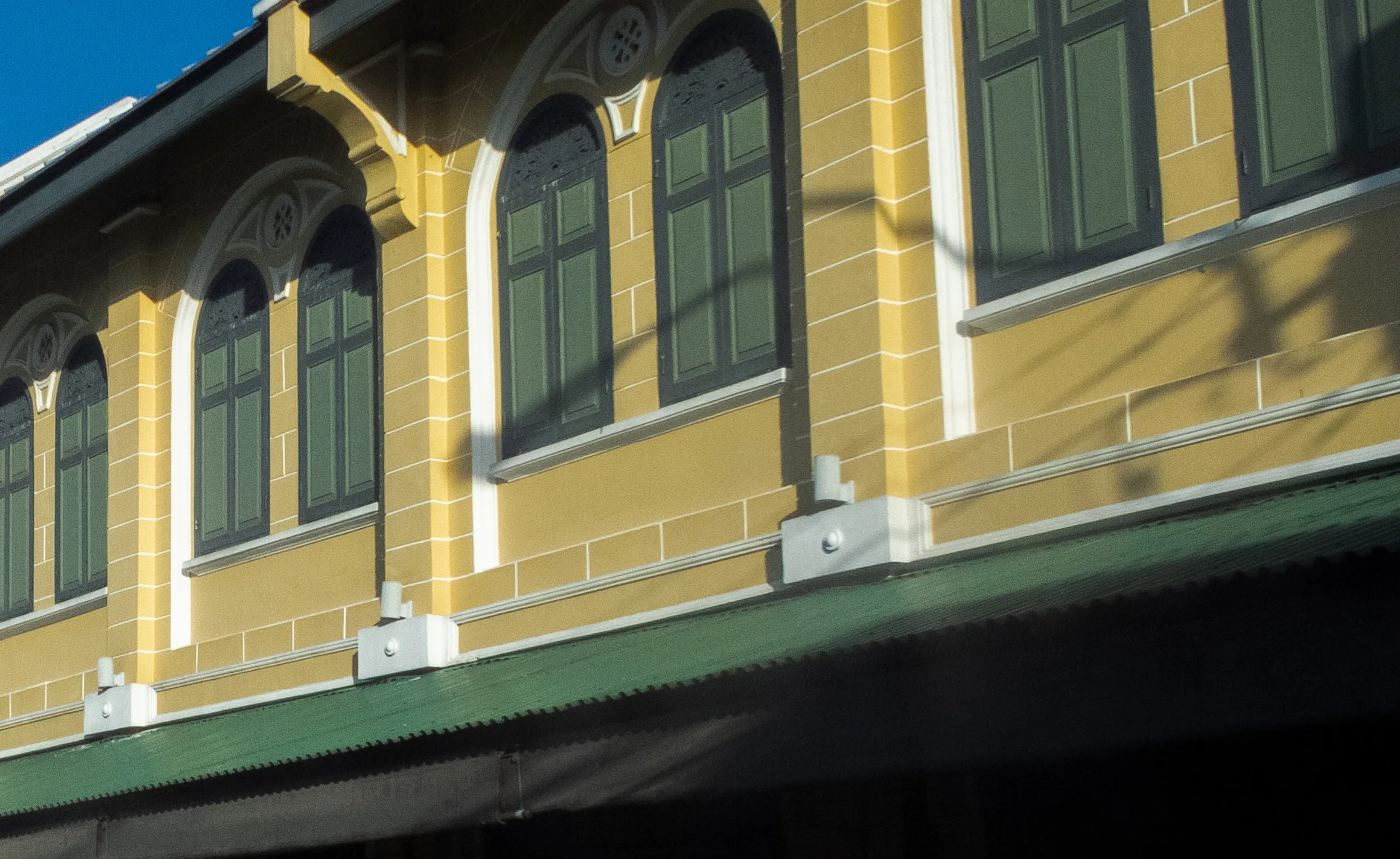
The way into Tha Tien is a row of yellow shophouses with green shutters and a deep awning. People use the pavement. Cars use the road. This is still a street, not yet the landing. At the end of Thai Wang Road the street meets the Chao Phraya. Boats leave from Tha Tien, including the short crossing to Wat Arun on the opposite bank. The river is why the old city sits here. It is also the edge of this walk.
The picture is those shophouses, on the public street about a hundred metres before the ferry. It is the approach you can recognise, not the pier building. The landing has been rebuilt since the timber sheds that stood over the water in 2018, and this chapter does not use that older picture as the view of arrival. Shade is scarce near the water, and people waiting for a boat share a narrow edge with people working it. If you are only passing through, the public side is enough.
The boat to Wat Arun is useful if that temple is a separate plan. It is not a path this map draws between this chapter and the next. Wat Arun is not on the line. Once you board, you have left the walk. This chapter does not offer a look-around. The photograph is the street, not a tour of the rebuilt landing.
Stay on the public side. Leave room for anyone carrying goods or stepping aboard. The far bank’s prang can be seen from the water. Seeing it is not the same as having walked there. When you are ready to continue, return to the street and turn south. The flower market is still on this bank. The river wind is stronger than it was on the palace lawn. A few minutes at the edge is enough.
Real-travel note
This is a working pier. The photograph is the shophouse street on the way there, from 2022, not the rebuilt landing. Recheck boat notices before you board, and do not treat the crossing as part of the walk.
Chapter 4 · Flowers as work
Pak Khlong Talat
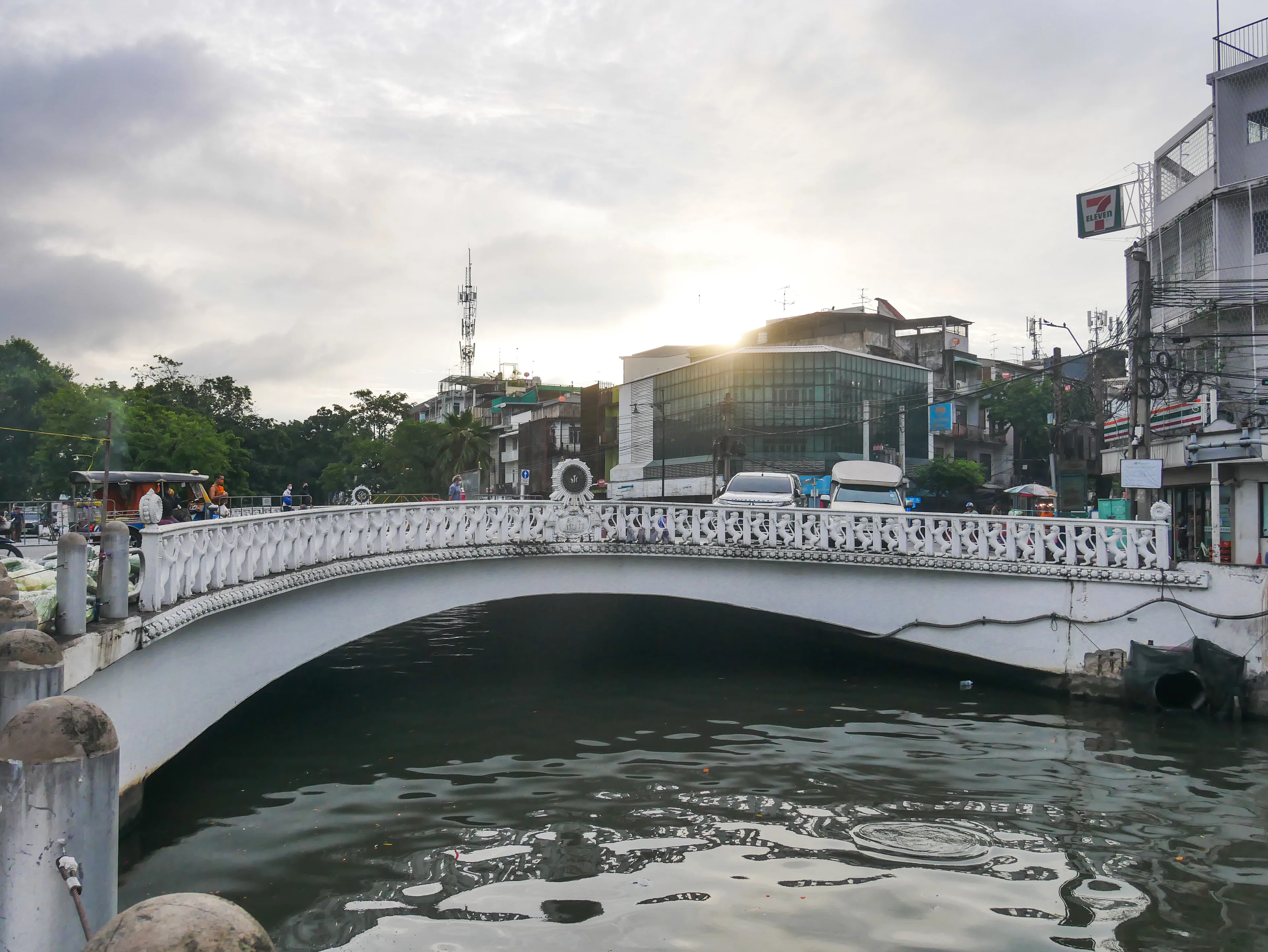
South of the pier, Maharat Road and then Ratchini Road bring you to Chakphet Road. The corner is a white canal bridge, a busy junction and the edge of Pak Khlong Talat. Trucks, taxis and people carrying bundles share the road. The flower market is not a backdrop set up for visitors. It is where flowers are sorted, strung and sold, across several markets rather than one stall with one timetable.
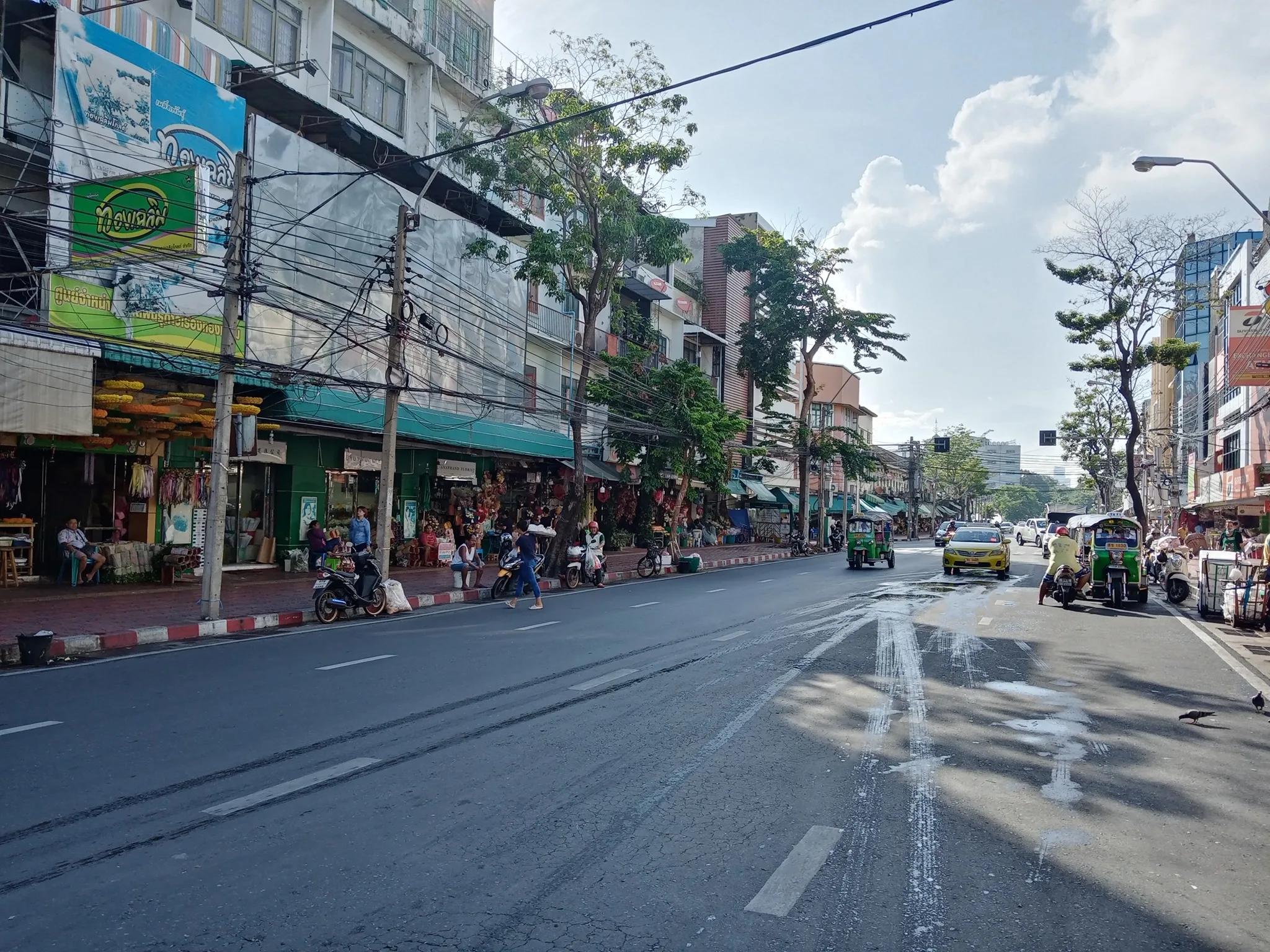
The main picture is Chakphet Road through the market on 24 June 2020: shopfronts and hanging garlands along the street. The file has no GPS, so it is the photographer’s record of this road, not a measured point on the bridge. A second picture is Charoenrat 31 Bridge at 6:27am on 22 July 2023. The canal and the pale balustrade are the corner where this walk arrives. Neither picture is a stall aisle. Come for the flowers and the density of goods changes a short way along the street: more finished garlands at one hour, more road at another. Leave room for anyone moving stock. A person at work is not part of the view.
The mapped stop is this public corner. The optional 360° view, if you open it, is the junction itself: traffic, the canal and shopfronts. It does not walk you down the stall aisle, and it does not carry you along the street to the river.
The Tourism Authority of Thailand describes Pak Khlong as a fresh market by day and a flower market in the evening, with flower stalls at night that can reach the entrance of Suankularb Wittayalai. The same page names four markets that do not share one operator. Stalls do not keep one set of hours. Recheck locally if a particular hour matters to you. When you leave, the river is a few minutes south, at the bank beside Memorial Bridge.
Real-travel note
This is a workplace. The main photograph is Chakphet Road on 24 June 2020, and the second is the canal bridge on a July morning in 2023. Neither is every hour of the trade. Give people room to work, and recheck the day’s rhythm before you plan around one picture.
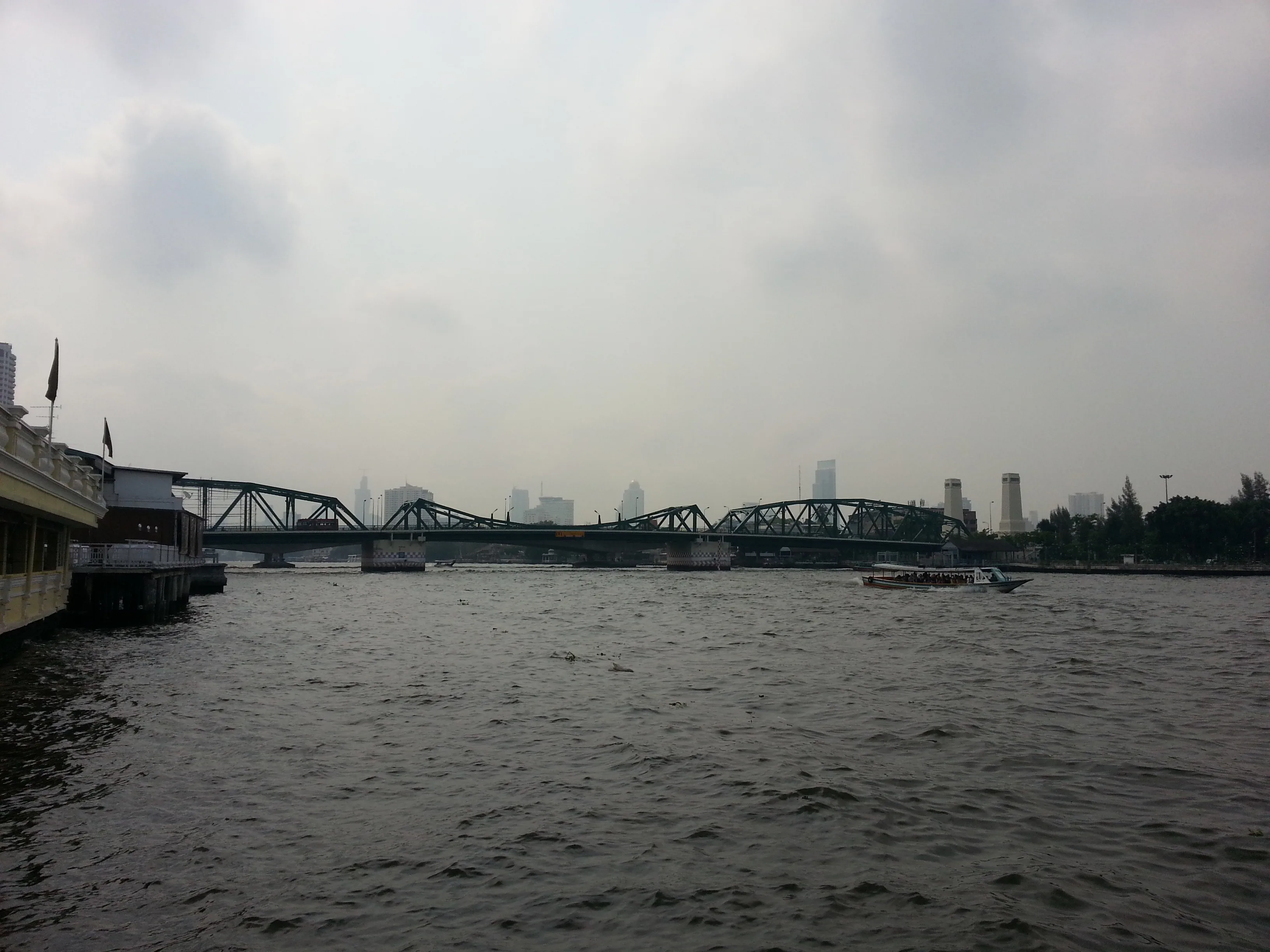
Chapter 5 · The bridge, from the bank
The riverbank by Memorial Bridge
From the market corner the streets turn toward the river again: Atsadang, a short soi, and the way called Yodpiman Riverwalk. You come out on the bank with Memorial Bridge in front of you. The green truss and the pale pylons on the far side are the last large shape of this walk. The water separates the two banks. You are still on the Phra Nakhon side.
This journey stops on the bank and does not include a crossing. The bridge deck used by vehicles is a road: OpenStreetMap marks that roadway foot=no. That tag is the deck, not a finding that the whole bridge and every path beside it are closed to walking. Chao Phraya Sky Park is a separate elevated footway mapped alongside the bridge. Neither the vehicle deck nor the sky park has been reviewed as part of this walk, so neither is drawn. Crossing to Thonburi, by any of those routes or by boat, is a further choice. It is not the next chapter.
A boat in the photograph is traffic on the water, not the path you walked. This chapter does not offer a look-around. The picture is the bridge from the public edge in daylight. The path along the water can be blocked by stalls or works, so look again when you arrive.
This is a reasonable place to stop. You have come from the palace wall, past a temple you could enter or leave, to a pier, a market and the river. The heat, the tickets and the dress rules were the decisions. The bridge tells you where the old city meets the water.
Real-travel note
Stay on the bank. This walk does not cross Memorial Bridge. The photograph is a daytime view from 2015. Recheck access along the river edge before you go.
Sources
- Schedules — The Grand Palace
- Practical Information — The Grand Palace
- Buy tickets — The Grand Palace
- FAQ — The Grand Palace
- Visit plan — Wat Pho
- Wat Pho — Wat Pho
- Viset Chaisri Gate — OpenStreetMap
- Mani Noppharat Gate — OpenStreetMap
- Reclining Buddha hall, Wat Pho — OpenStreetMap
- Tha Tien ferry terminal — OpenStreetMap
- Wat Arun Pier — OpenStreetMap
- Chakphet Road — OpenStreetMap
- Pak Khlong Talat — OpenStreetMap
- Pak Khlong Talat Night Market — Tourism Authority of Thailand
- Footway on the bank north of Memorial Bridge — OpenStreetMap
- Memorial Bridge vehicle way — OpenStreetMap
- Chao Phraya Sky Park — OpenStreetMap
- Phra Borom Maha Ratchawang, Phra Nakhon, Bangkok, Thailand - panoramio (97) — Wikimedia Commons
- พระวิหารพระพุทธไสยาส — Wikimedia Commons
- ตึกแถวท่าเตียน — Wikimedia Commons
- (2023) สะพานเจริญรัช 31 เขตพระนคร กรุงเทพมหานคร (1) — Wikimedia Commons
- ถ.จักรเพชร-ปากคลองตลาด — Wikimedia Commons
- Wang Burapha Phirom, Phra Nakhon, Bangkok, Thailand - panoramio (18) — Wikimedia Commons
.jpg)


_%E0%B8%AA%E0%B8%B0%E0%B8%9E%E0%B8%B2%E0%B8%99%E0%B9%80%E0%B8%88%E0%B8%A3%E0%B8%B4%E0%B8%8D%E0%B8%A3%E0%B8%B1%E0%B8%8A_31_%E0%B9%80%E0%B8%82%E0%B8%95%E0%B8%9E%E0%B8%A3%E0%B8%B0%E0%B8%99%E0%B8%84%E0%B8%A3_%E0%B8%81%E0%B8%A3%E0%B8%B8%E0%B8%87%E0%B9%80%E0%B8%97%E0%B8%9E%E0%B8%A1%E0%B8%AB%E0%B8%B2%E0%B8%99%E0%B8%84%E0%B8%A3_(1).jpg)

.jpg)
Your journey, remembered.
The keepsake unlocks when you reach this section.