
Sydney The Rocks: harbour edges, sandstone and a hilltop
Leave the ferry concourse for a small waterfront cottage, former warehouses, a rock cutting and Observatory Hill. Five chapters, fifteen dated photographs and six optional local street-imagery experiences reveal different layers of Sydney, without pretending they form one connected virtual walk.
Begin the visual journeyExplore 6 reviewed views along the routeGuided visual journey
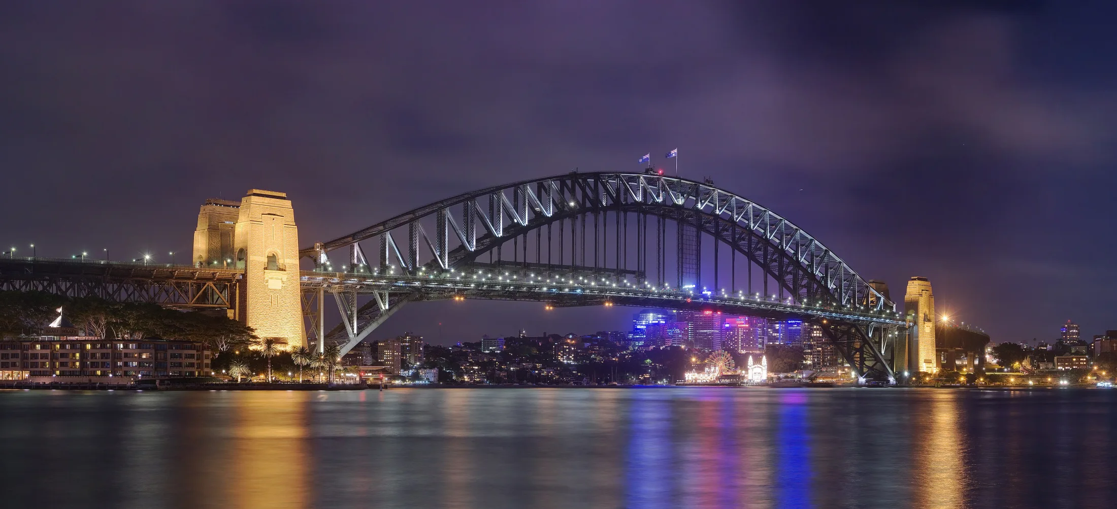
Sydney Harbour Bridge lit across Circular Quay at night · JJ Harrison · CC BY-SA 3.0
Reading mode
Place stories to read at your own pace
Compare three independently framed, dated photographs. These are different viewpoints, not consecutive walking frames.
Chapter 1 · A harbour that moves
Start where the ferries meet the city
Circular Quay works as an arrival rather than just a viewpoint. Ferry wharves project into the water while the city gathers behind the concourse. The Opera House lies on the eastern side of the cove; the Harbour Bridge and The Rocks draw attention west. Before picking an icon, notice the working foreground: entrances, queues, shade and paths shared by people heading somewhere else.
The three photographs deliberately do not imitate consecutive steps. JJ Harrison’s 2010 night view follows the bridge lights across dark water. Pratyeka’s 2015 overview was taken from the Harbour Bridge, well above this chapter’s pedestrian starting point. David Minty’s 2018 eastern-quay photograph concentrates on illuminated colonnades. Together they explain orientation and atmosphere, but neither the lighting nor the camera height is a promise about your visit.
For a street-level comparison, the optional September 2024 Google sequence starts beside Wharf 4. Two checked local moves follow the concourse west; you can also turn around and return. This small observation cannot carry you through the following chapters. Keep ferry entrances clear in person, check current transport information and use the dated images to form questions rather than to navigate a live interchange.
Real-travel note
Keep ferry queues and boarding gates clear. Check current services, waterfront works and weather; the elevated overview is not this chapter’s ground-level camera position.
Compare three independently framed, dated photographs. These are different viewpoints, not consecutive walking frames.
Chapter 2 · The shoreline moved
Find the small cottage behind the harbour
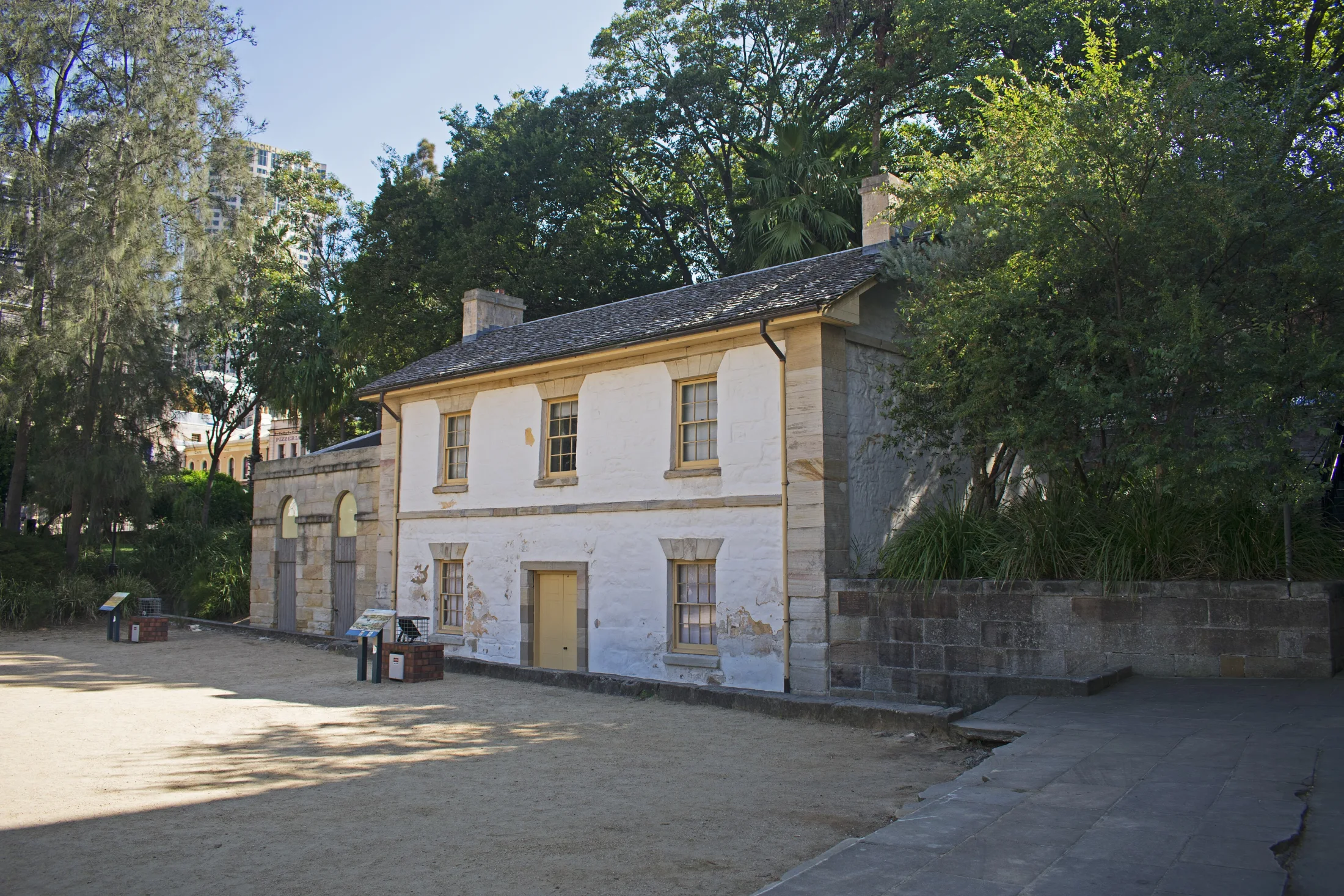
Cadmans Cottage makes the harbour’s changing edge easier to understand. Its low roof and restrained pale façade are small beside the larger public spaces and buildings nearby. NSW National Parks dates it to 1816 and describes its successive maritime uses. It once stood at the waterfront; reclamation has left it roughly a hundred metres inland. The gap between house and water is therefore part of the story, not empty space to ignore.
Ymblanter’s two photographs from 1 April 2024 approach the building from different sides. The northeastern view gives the façade room to breathe; the northwestern frame looks through trees toward the roof. Dietmar Rabich’s 2019 George Street sign is a contextual detail from The Rocks, not a third view inside the cottage or proof of an entrance. Use the set to compare scale, shade and street identity rather than to reconstruct a single camera path.
At research time the precinct’s official listing marked the cottage closed for conservation, so this chapter stays outside. The September 2024 Google sequence follows two checked moves on the adjacent stair approach toward George Street, not a tour through the house. Turn to compare the setting, then return to the photographs. Historic imagery cannot prove that a gate, staircase or interior is open today.
Real-travel note
The official listing marked Cadmans Cottage closed at research time. Recheck notices; this chapter observes the exterior and an adjacent stair approach, not interior access or a step-free route.
Compare three independently framed, dated photographs. These are different viewpoints, not consecutive walking frames.
Chapter 3 · Warehouses facing the water
Read Campbells Cove in three different moments
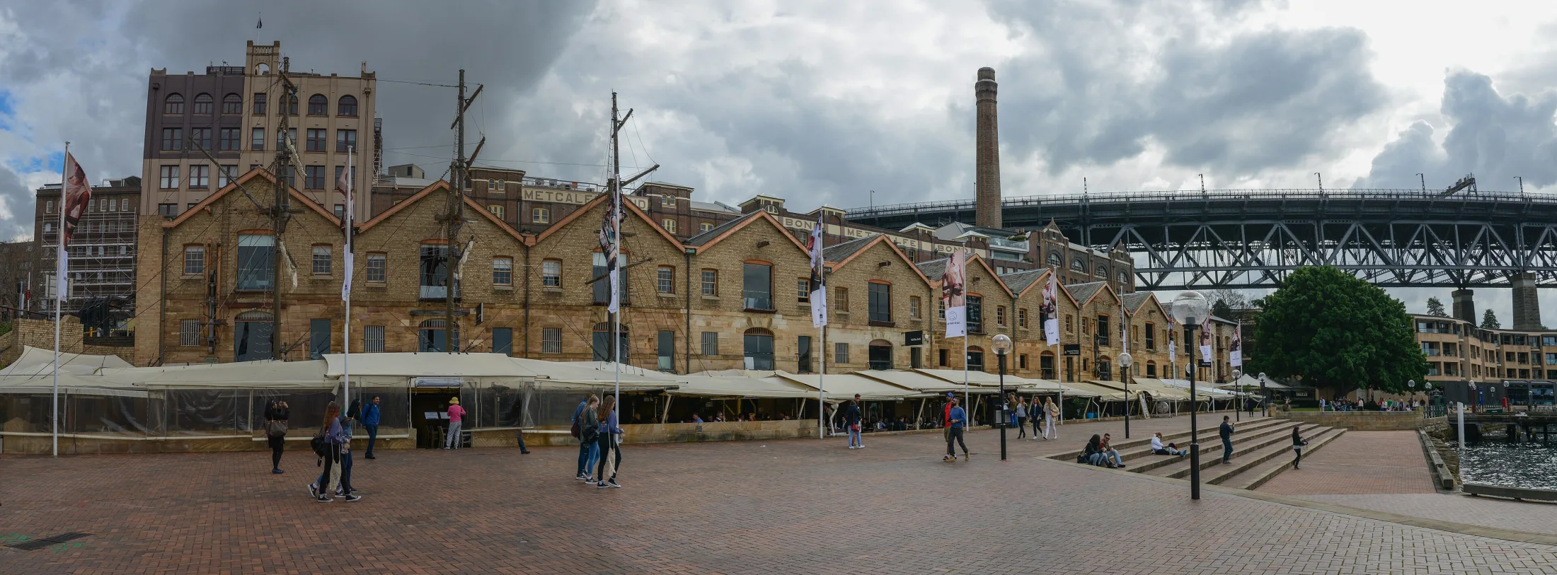
At Campbells Cove, the waterfront is both an open foreground and the setting for a long row of former warehouses. Jorge Láscar’s 2016 photograph lets the repeated gables and sandstone faces hold the frame. Instead of rushing toward the bridge, compare the rhythm of doors, the breadth of paving and the way a working harbour frontage has become a place to pause.
Dicklyon’s Christmas 2022 panorama rearranges the same broad setting with night lighting and the bridge beyond. The third photograph, made in November 2024, documents jetty construction near the Overseas Passenger Terminal. It is included because an edge of the harbour is not a permanent stage: works, vessel operations and events can change how it is used. The portrait-format image is a dated detail, not evidence that the jetty is currently closed or currently available.
The official venue page describes a paved waterfront space with pedestrian approaches from Hickson Road and George Street North. Our optional September 2024 Google view is an outdoor waterfront observation, with the Opera House visible across the water. It is published as a single look-around, even though the provider may hold other imagery nearby. Nothing here guarantees an unobstructed promenade or a connection to the next chapter.
Real-travel note
Check current signs around the Overseas Passenger Terminal and waterfront events. The jetty photograph records November 2024 construction only; do not infer today’s closure or opening from it.
Compare three independently framed, dated photographs. These are different viewpoints, not consecutive walking frames.
Chapter 4 · A city with more than one level
Look through the sandstone of Argyle Cut
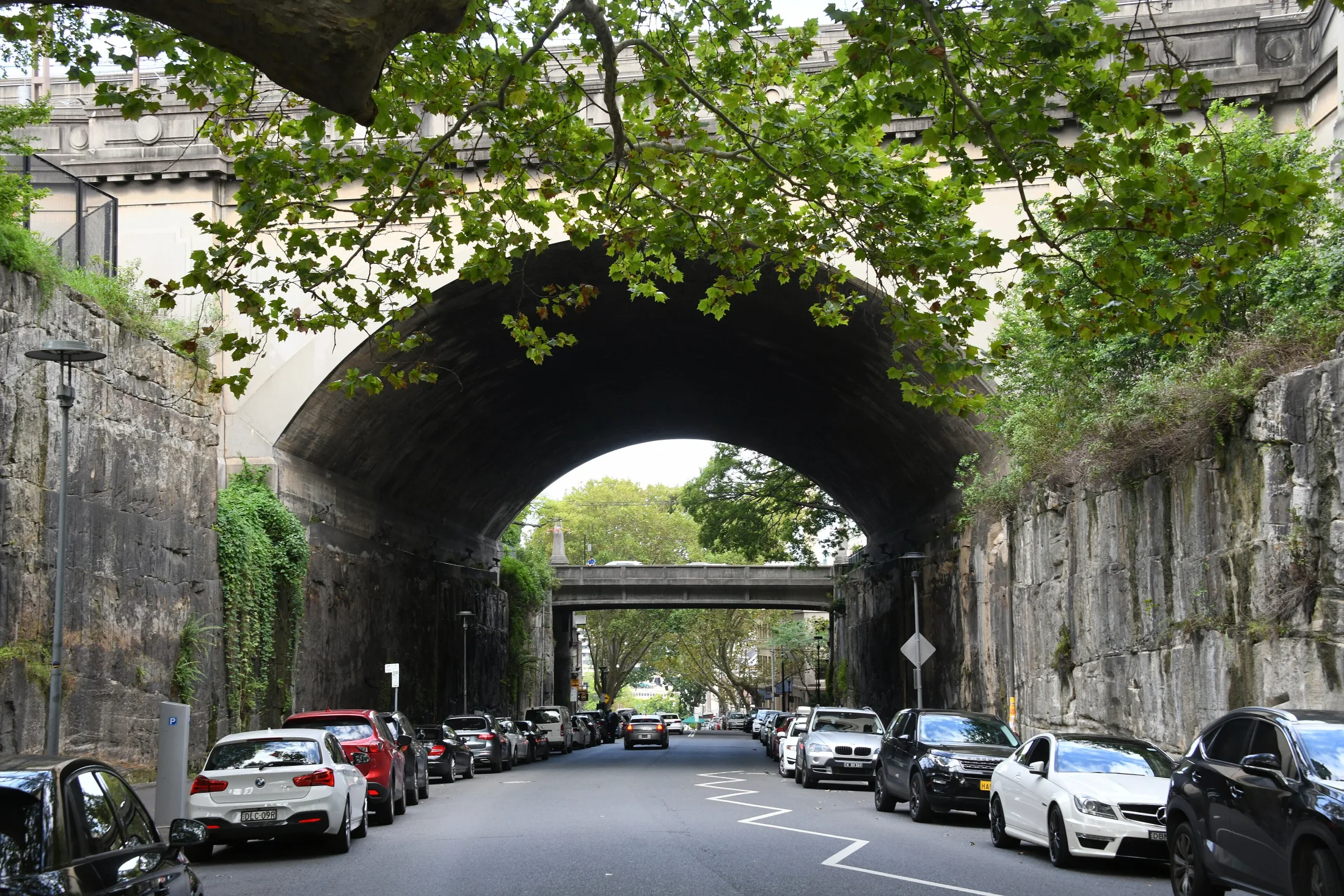
Argyle Cut changes the scale of the journey. The broad water edge gives way to a street held between sandstone walls and bridge structures. In Sardaka’s 2020 photograph, cars and pedestrians are small enough to make the rock cutting readable. Follow the rough wall surfaces up toward the arch, then back down to the ordinary curb: monumental engineering and everyday street use occupy the same frame.
Dicklyon’s December 2022 photograph moves beneath the Harbour Bridge approach, where the ceiling of an arch and the parked cars reveal how several urban levels overlap. Collywolly’s 2019 view of Argyle Stairs shows the practical consequence: some nearby connections are stairways rather than a gentle continuation of the pavement. These are three independently identified documentary views. They do not establish a safe crossing, a stair-free itinerary or a consecutive sequence between camera positions.
The optional July 2024 street imagery adds three checked views through the lower Argyle Street cutting, with a return. You can turn toward the sandstone walls and compare the arch with the older photographs. Earlier candidates on Cumberland Street or Bradfield Highway were excluded because a nearby coordinate is not enough when roads overlap vertically. This camera travels in the road: the limited sequence is an observation tool, not a safe pedestrian route or a connection to the next chapter. Use current pedestrian maps and on-site signs for a real visit.
Real-travel note
Expect traffic, changing street levels and stairs. The July 2024 views use road-centred camera positions, not pedestrian directions. Use crossings and current access information; no step-free connection is promised.
Compare three independently framed, dated photographs. These are different viewpoints, not consecutive walking frames.
Chapter 5 · Let the harbour widen again
Finish above the roofs at Observatory Hill
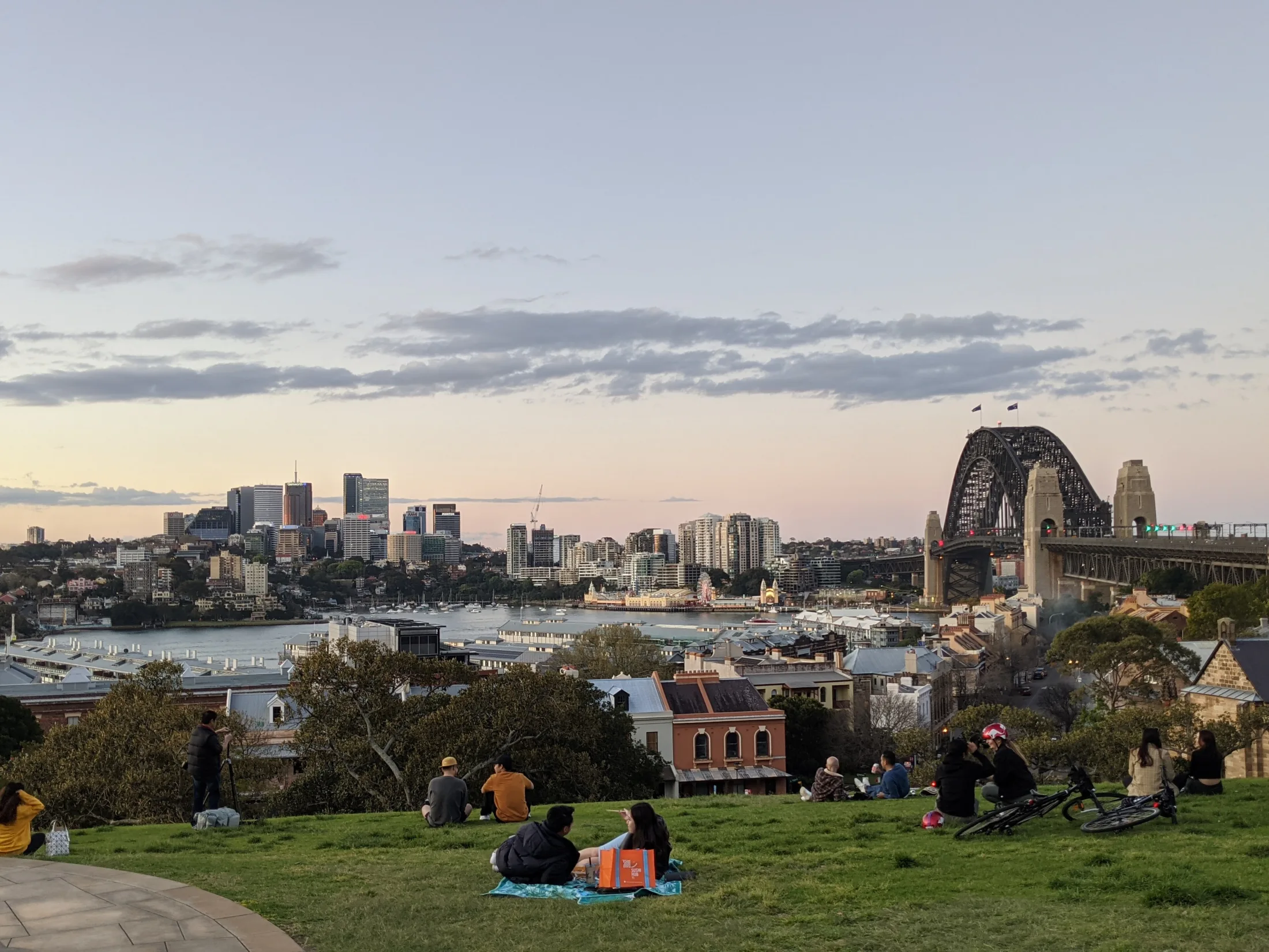
Observatory Hill releases the journey from the narrow cutting into trees, lawn and a long harbour view. MDRX’s September 2020 photograph places seated people in the foreground and the Harbour Bridge beyond. Robert Linsdell’s 2012 sunset turns attention farther across the water. The different dates, directions and light make this a comparison of possibilities, not a guaranteed sunset seat or one reconstructed evening.
The park is on Gadigal Country. The City of Sydney’s park management plan places the colonial landscape within that older context, including dispossession; the harbour story does not begin with a cottage, warehouse or observatory. The city’s park page dates the observatory’s construction to 1857–1859. Dicklyon’s 2022 photograph isolates its tower and lowered time ball, adding an institutional detail to the much wider public landscape.
The optional August 2019 Google sequence stays beside the park’s large trees and benches, with two short checked moves and a return. It does not enter the observatory. Park access and an observatory visit are separate decisions: check current tour bookings and notices rather than treating a photographed gate as an invitation. Finish by comparing canopy, slope and harbour visibility, and leave the site as a living public place rather than a backdrop.
Real-travel note
The public park and observatory tours have separate access arrangements. Check current notices and bookings, allow for slopes and weather, and keep paths and benches available to others.
6 reviewed experiences
Explore along the route
Step into the places along this journey. Choose a view independently of the story chapters. Free previews do not count toward chapter progress. Return to the journey above to continue through its stops.
Start where the ferries meet the city Short observation sequence
September 2024: two checked local moves by Wharf 4 and a return. This does not connect to the other chapters.
Reviewed 2026-10-11 · At the place
Explore at your own pace; these views do not count toward chapter completion. Check each point's coverage note before navigating provider imagery. Availability may change.
Sources
- Circular Quay — Destination NSW
- The Rocks — Destination NSW
- Getting here — Place Management NSW
- Cadmans Cottage — Place Management NSW
- Cadmans Cottage Historic Site — NSW National Parks and Wildlife Service
- Campbells Cove — Place Management NSW
- Observatory Park — City of Sydney
- Observatory Park Plan of Management — City of Sydney
- Sydney Observatory — NSW Government
- AUS Sydney, Central Business District, Mill Lane 001.jpg — Wikimedia Commons
- Sydney Harbour Bridge from Circular Quay.jpg — Wikimedia Commons
- Circular Quay from Sydney Harbour Bridge (2015-02-08).jpg — Wikimedia Commons
- East Circular Quay2.jpg — Wikimedia Commons
- Sydney The Rocks Cadmans Cottage seen from the northeast.jpg — Wikimedia Commons
- Sydney The Rocks Cadmans Cottage seen from the northwest.jpg — Wikimedia Commons
- Sydney (AU), The Rocks, George Street -- 2019 -- 3567.jpg — Wikimedia Commons
- Panorama of the buildings that were once warehouses in Campbell's Cove (The Rocks district) (28997160582).jpg — Wikimedia Commons
- Campbell's Cove night pano, The Rocks, Sydney, NSW.jpg — Wikimedia Commons
- Campbells Cove Jetty.jpg — Wikimedia Commons
- Argyle Cut 001.jpg — Wikimedia Commons
- In the Argyle Cut below the Sydney Harbour Bridge approach.jpg — Wikimedia Commons
- Argyle Stairs 03.jpg — Wikimedia Commons
- Observatory Hill Sydney.jpg — Wikimedia Commons
- View from Observatory Hill, Sydney (483412) (9440283597).jpg — Wikimedia Commons
- Sydney Observatory with time ball.jpg — Wikimedia Commons


.jpg)


,_The_Rocks,_George_Street_--_2019_--_3567.jpg)
_(28997160582).jpg)


_(9440283597).jpg)

Your journey, remembered.
Explored 0 of 5 stops. Explore every stop to unlock your keepsake.
5 stops to your keepsakeExplore every stop to share or download your keepsake.