
Porto old town: from painted tiles to the Douro
Read a working station, a cathedral hill, a balcony-lined street and both sides of the Douro. Five chapters, sixteen licensed photographs and seven optional local street-imagery experiences offer different ways into Porto—not one uninterrupted virtual walk.
Begin the visual journeyExplore 7 reviewed views along the routeGuided visual journey
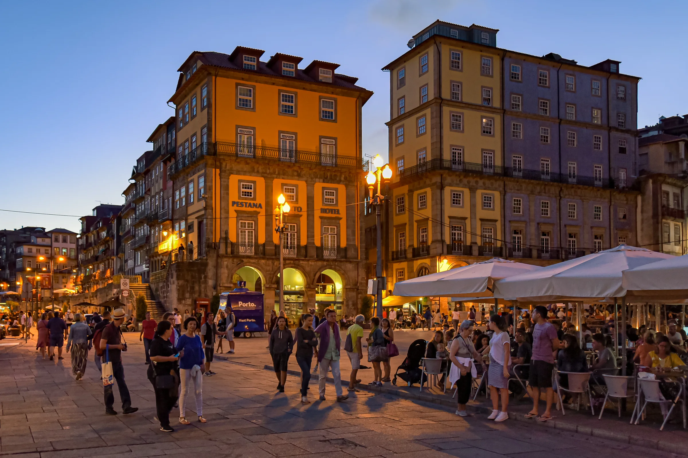
Ribeira square, waterfront terraces and façades at dusk · Jorge Franganillo · CC BY 2.0
Reading mode
Place stories to read at your own pace
Use the arrows to compare independently made photographs. They are not consecutive walking frames.
Chapter 1 · An arrival written in tiles
Start at São Bento, not just in front of it
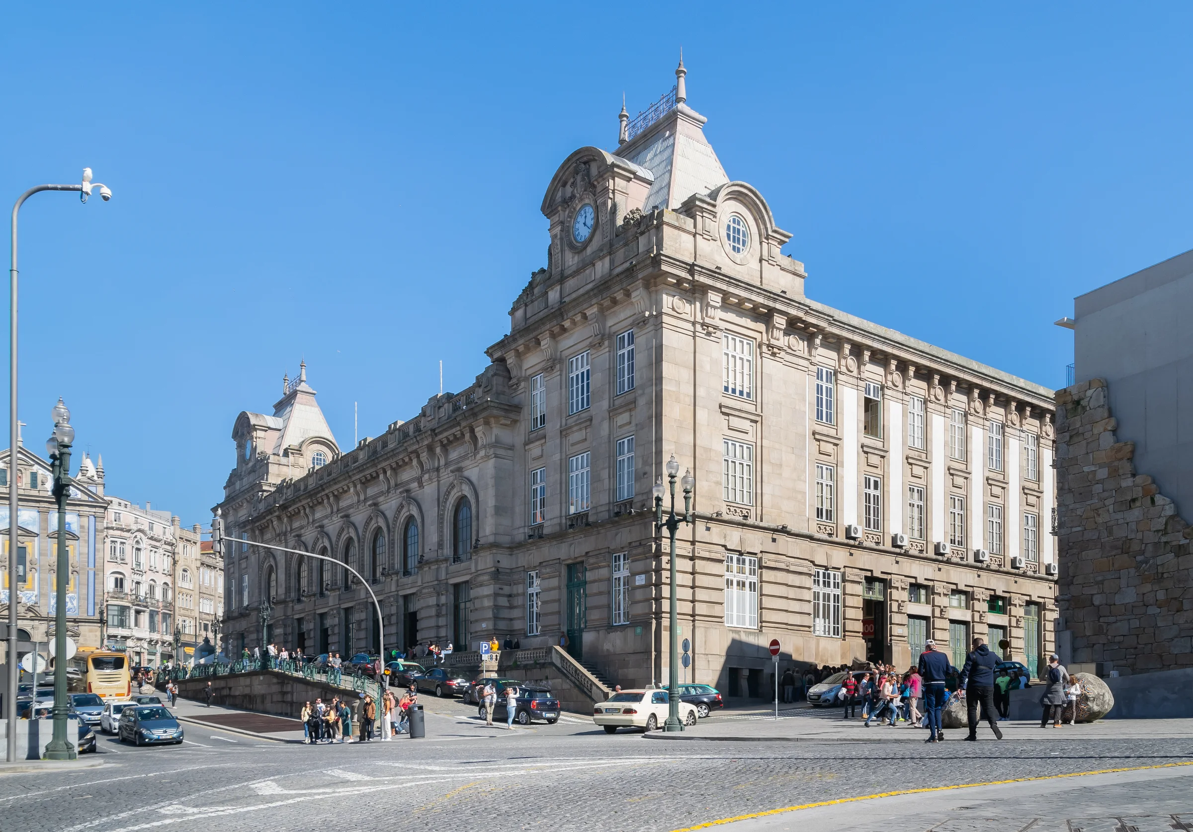
Begin with the station as a place of arrival. The façade faces Praça de Almeida Garrett, where city movement meets the railway. Inside, painted tile panels invite a slower kind of looking, while the platforms behind them still serve passengers. A useful first question is not how quickly you can collect a landmark photograph, but where you can pause without interrupting someone else’s journey.
Four dated photographs separate those layers. Krzysztof Golik’s façade view gives the building a place in the square; Diego Delso’s close framing lets the tile compositions fill the screen. Dicklyon looks along the platforms toward the tunnel, while K1008 records trains and the lit shed at night. None is the next frame of another. Use the arrows to move between exterior, decoration and railway function, rather than expecting an indoor walk through the station.
Visit Porto identifies the tile painter as Jorge Colaço. Railway heritage information places the station on the former convent site: the present arrival space carries an earlier urban layer. The optional July 2026 Google sequence adds three checked positions outside the façade, with a return. It does not enter the tiled hall or platforms. Historical imagery can help you understand the building’s scale, but departures, works and permitted access must be checked separately when you go.
Real-travel note
Keep entrances and passenger routes clear. The Google sequence is outside and road-centred; it is not platform access, a station interior tour or live railway guidance.
Use the arrows to compare independently made photographs. They are not consecutive walking frames.
Chapter 2 · Read the city’s height
Let the cathedral explain the hill
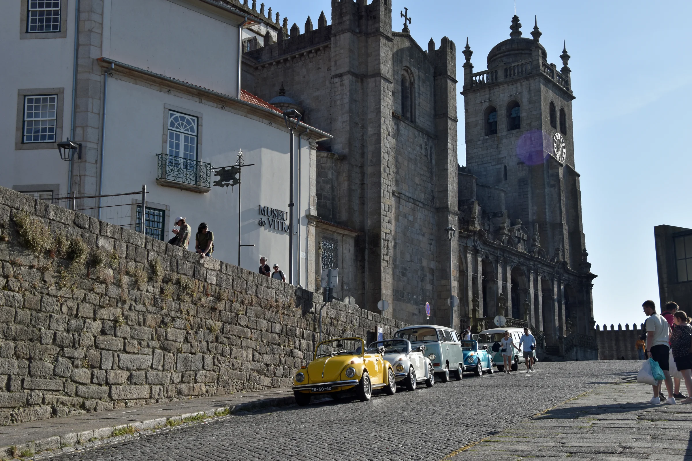
The cathedral changes the way Porto’s centre is read. The building’s mass, the stone paving and the roofs beyond make height visible before you descend toward the river. Look at the relationship between the approach and the façade: a short distance on a flat map can conceal a climb, a stairway or a different street level. This chapter is an observation stop, not a promise of an easy or step-free connection from the station.
Thomas Dahlstrøm Nielsen’s July 2023 photograph approaches from a cobbled street. The two May 2025 photographs by JensKunstfreund move to different scales: a tower against city roofs and a view through interior stone arches toward the altar. The high tower camera position is not the outdoor street-view entrance. The interior is a licensed still, not a location that this product’s Google experience can take you into.
The city tourism listing describes a cathedral repeatedly enlarged and renewed over time, rather than a single untouched medieval object. Compare the heavy exterior with the interior’s more concentrated light. The optional October 2024 sequence follows three checked positions on Calçada de Dom Pedro Pitões outside the cathedral precinct, and allows a return. Scaffolding visible in those historical views records that date only. Admission, worship, tower access and any current works are separate questions to recheck with the venue.
Real-travel note
Expect slopes, uneven paving and changes of level. Interior photographs do not guarantee entry; check current cathedral visiting arrangements and respect worship and photography restrictions.
Use the arrows to compare independently made photographs. They are not consecutive walking frames.
Chapter 3 · The street is the collection
Slow down between the balconies of Rua das Flores
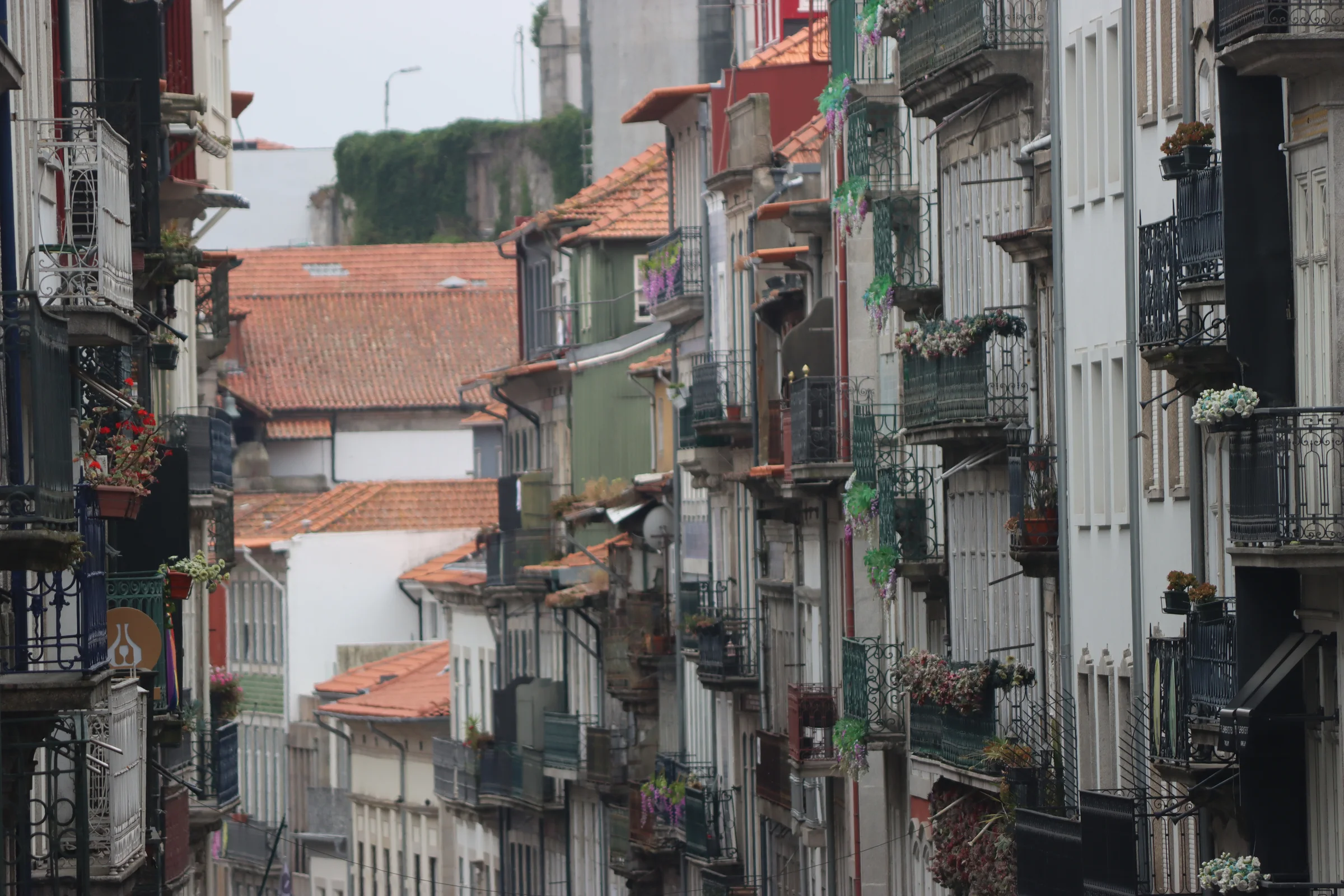
Rua das Flores rewards attention at more than one height. At ground level, entrances, shopfronts and people keep the street moving. Above them, balconies, tiles and window frames form a slower rhythm. Follow a façade up and then look back along the street: an everyday commercial setting can be more revealing than a single monumental object. Keep private windows and doorways as parts of the setting, not invitations to intrude.
The photographs offer three distinct ways of looking. thirdsphoto’s May 2023 street view follows the balconies into the distance. John Samuel’s September 2016 photograph looks up at paper lanterns suspended between buildings; those decorations belong to that moment and are not a permanent attraction. prilfish’s October 2017 frame concentrates on a Rua das Flores information plaque beside a tiled entrance. Together they move from street scale to temporary atmosphere and close detail.
Visit Porto dates the opening of the street to 1521. Our optional October 2024 Google sequence stays on Rua das Flores itself, beginning near number 194 and moving through two reviewed adjacent positions before returning. Candidates on neighbouring Mouzinho da Silveira and Afonso Martins Alho streets were not substituted for this location. Turn around and compare the street’s width with the stills, remembering that shops, crowd levels and delivery access may have changed. This local sequence does not continue down to the river.
Real-travel note
Leave doorways and service access clear; respect residents and workers. Lanterns are documented in a 2016 photo only. Use current pedestrian maps for the descent rather than following the camera path.
Use the arrows to compare independently made photographs. They are not consecutive walking frames.
Chapter 4 · A city facing the water
Read Ribeira from the square and across the river
At Ribeira, the city opens onto the Douro, but the hillside remains close behind. Terraces, paving, river traffic and stacked façades compete for attention. Rather than treating the waterfront as one continuous postcard, separate the near ground where people pass from the long elevation rising behind it. That distinction helps explain why a photograph made across the river cannot tell you the width or accessibility of the path beneath those buildings.
Jorge Franganillo’s August 2017 evening photograph brings the square, café terraces and warm windows into one frame. The daylight riverfront images by Lark Ascending and Frédérique Voisin-Demery reveal the buildings from outside that immediate square; the latter explicitly identifies the opposite bank as the camera position. These are complementary views, not successive steps and not three images from the same evening. Switch between them to compare how the skyline disappears when you stand close to a façade.
The national tourism account places Ribeira on a descent from the cathedral district and connects the story to Gaia across the river. Our October 2024 Google observation is much smaller: three linked positions west along Rua da Fonte Taurina, with a return. At the starting street corner, rotate for riverfront context. It is not a walk across the entire quay. Outdoor tables, pedestrians and changing riverfront operations shape the real passage; check signs, weather and access rather than inferring today’s conditions from the historic scene.
Real-travel note
Stay on public pedestrian space and away from the water’s edge. The short Google street sequence is local only; it does not establish a crossing of the bridge or current access along the whole riverfront.
Use the arrows to compare independently made photographs. They are not consecutive walking frames.
Chapter 5 · Change banks, change the view
Let Gaia turn Porto into a skyline
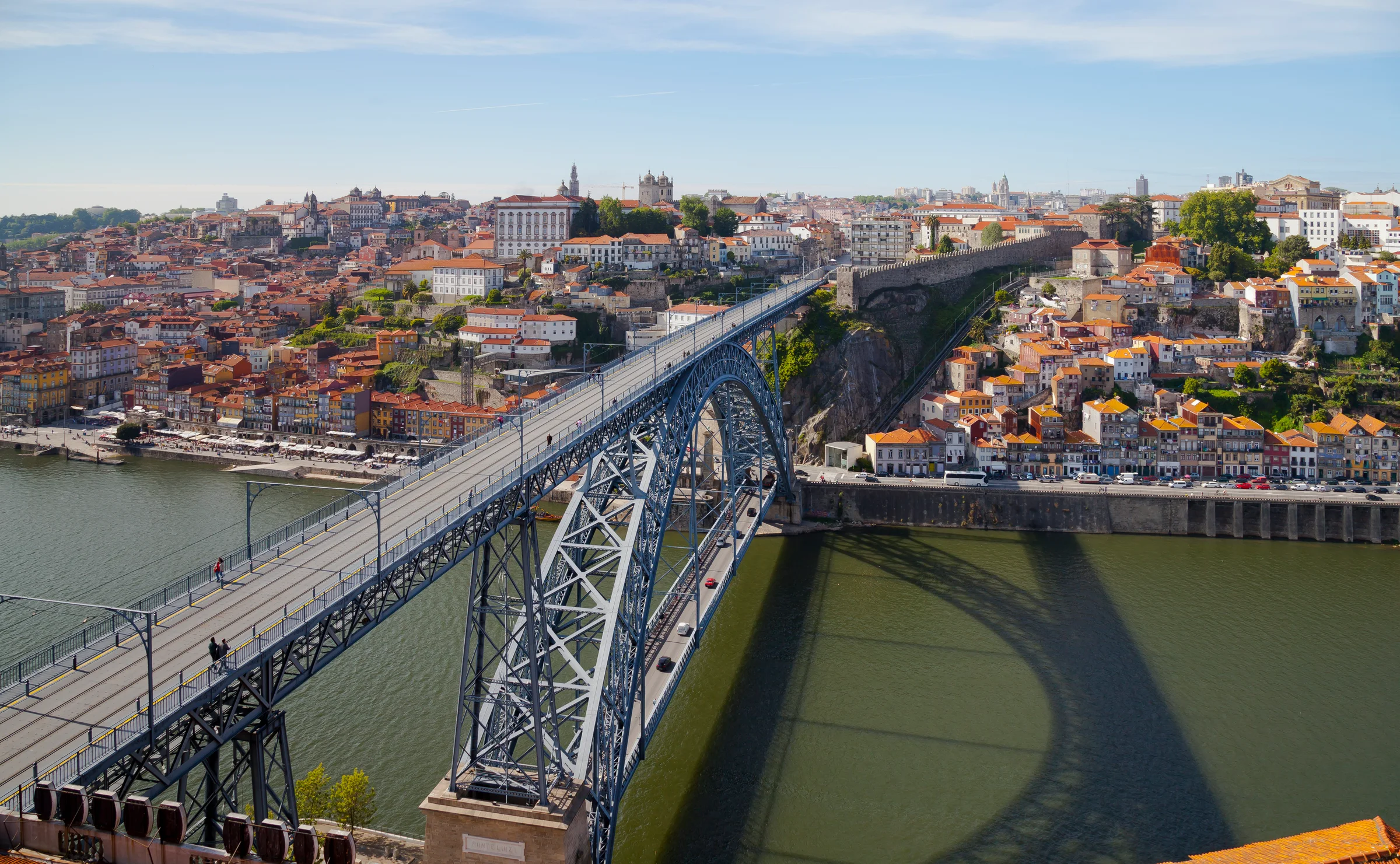
On the Gaia bank, Porto becomes a whole hillside rather than a sequence of nearby doors. The bridge connects two urban edges, but it also introduces a crucial choice of height. Its upper and lower decks are not interchangeable viewpoints or entrances. Decide which level fits a real itinerary using a current pedestrian map; this editorial jump across the river is not an instruction to follow a street-view camera in the carriageway.
Diego Delso’s May 2012 photograph makes the bridge’s two levels legible against the Douro. José Luiz’s January 2013 dusk view looks back toward Porto from Gaia, while prilfish’s October 2017 photograph turns to the restaurants and paved spaces on Gaia’s own waterfront. Looking both across and along the river avoids reducing this bank to a viewing platform for the other city. Notice the near-ground street uses as well as the skyline.
The optional June 2025 sequence follows three reviewed positions on Avenida de Diogo Leite; market stalls and vehicles belong to that capture, not to a guaranteed experience today. Along-route exploration also offers a separately checked local sequence on the bridge’s lower deck and a single June 2025 look-around at the street edge below Jardim do Morro. The latter is a higher-level detour, not a connected climb from the quay or a walk inside the garden. Compare it with the licensed sunset photograph without expecting the same light, then finish with your own questions about access, time and weather.
Real-travel note
Choose bridge level deliberately and use current pedestrian directions. Road-centred Google views are observation only. Jardim do Morro is uphill and separate from the quay; no step-free or continuous virtual connection is promised.
7 reviewed experiences
Explore along the route
Step into the places along this journey. Choose a view independently of the story chapters. Free previews do not count toward chapter progress. Return to the journey above to continue through its stops.
Start at São Bento, not just in front of it Short observation sequence
July 2026: three exterior street positions beside São Bento, with a return. No station interior or platform navigation; road-centred cameras are not pedestrian directions.
Reviewed 2026-10-12 · At the place
Explore at your own pace; these views do not count toward chapter completion. Check each point's coverage note before navigating provider imagery. Availability may change.
Sources
- Porto in a few days — Turismo de Portugal
- Estação de São Bento — Visit Porto
- Estação de Porto – São Bento — Infraestruturas de Portugal
- Sé Catedral — Visit Porto
- Rua das Flores — Visit Porto
- Historic Centre – Ribeira itinerary — Visit Porto
- Sao Bento train station in Porto (3).jpg — Wikimedia Commons
- Bahnhof Porto São Bento - am Abend.jpg — Wikimedia Commons
- Estación de tren São Bento, Oporto, Portugal, 2019-06-02, DD 05.jpg — Wikimedia Commons
- Inside Porto Sao Bento station.jpg — Wikimedia Commons
- Porto Cathedral, July 2023.jpg — Wikimedia Commons
- Die Türme der Kathedrale von Porto 02.jpg — Wikimedia Commons
- Innenaufnahmen der Kathedrale in Porto 06.jpg — Wikimedia Commons
- Porto, Portugal (52960575841).jpg — Wikimedia Commons
- Buildings in Porto 14.jpg — Wikimedia Commons
- Porto (38211486442).jpg — Wikimedia Commons
- Porto Cais da Ribeira (52625723657).jpg — Wikimedia Commons
- Portugal, Porto, Cais da Ribeira (52594164064).jpg — Wikimedia Commons
- Cais da Ribeira depuis l'autre rive (38437548831).jpg — Wikimedia Commons
- Puente Don Luis I, Oporto, Portugal, 2012-05-09, DD 13.JPG — Wikimedia Commons
- Porto from Gaia (10).JPG — Wikimedia Commons
- Vila Nova de Gaia - south of Porto - waiting for the tourists (38854810871).jpg — Wikimedia Commons
- The sunset as seen from Jardim do Morro, Porto, Portugal.jpg — Wikimedia Commons
.jpg)


.jpg)

.jpg)
.jpg)
.jpg)
.jpg)

.JPG)
.jpg)

Your journey, remembered.
Explored 0 of 5 stops. Explore every stop to unlock your keepsake.
5 stops to your keepsakeExplore every stop to share or download your keepsake.