
Bruges from the market to the Beguinage
Five chapters about the squares, canals and communities that shaped Bruges.
Begin the visual journeyPlan a real visit to Bruges Old TownExplore 9 reviewed views along the routeGuided visual journey
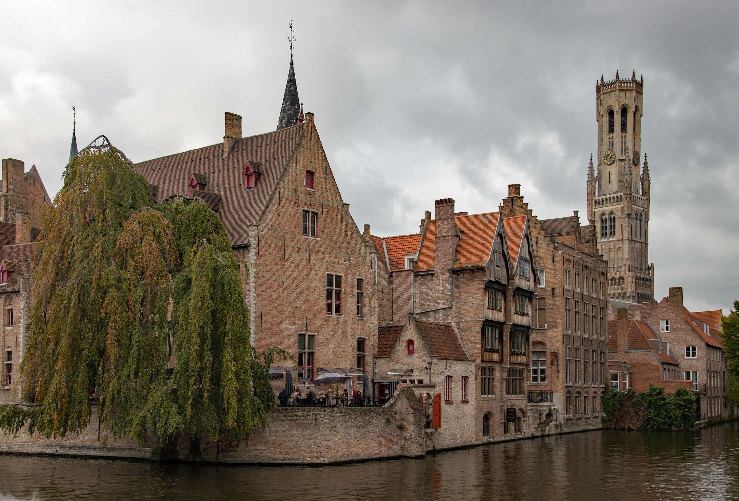
Rosary Quay and Belfry · Sally V · CC BY-SA 4.0 · Resized, WebP
Reading mode
Place stories to read at your own pace
Each photograph has its own camera position and capture date.
Chapter 1
Markt, the city’s trading square
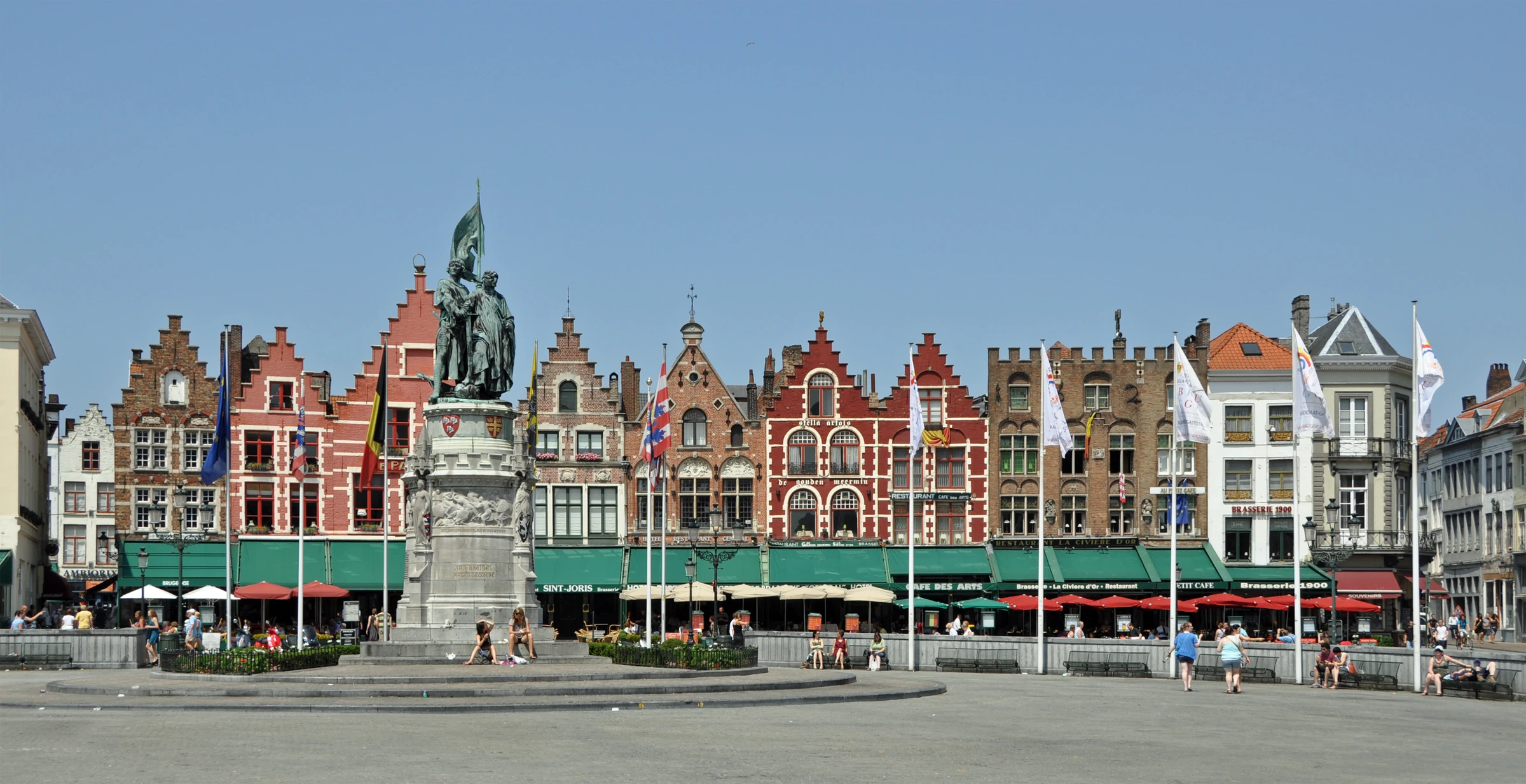
Begin at the Markt with the wide photograph of the north side. The houses form a low, varied wall behind the Breydel and De Coninck monument. At the opposite side, the Belfry rises above the long market halls, an arrangement you can examine from the Belfry’s separate 360° viewpoints. The halls provided a covered place to deal in goods, with the open square outside. In a city trading with merchants from across Europe, the centre needed space to store, sell and move bulk goods as well as space to gather. Flemish cloth helped drive the expansion of Bruges from the eleventh century onward. The square and hall complex put the scale of that trade into built form.
Move your attention across the open ground to the Provincial Court. Its elaborate stone front takes up much more of the square’s edge than an individual gabled house. The historical relationship between those buildings is more interesting than a common appearance of age. The site of the court once held the Water Hall, where cargo could be brought to a covered unloading place by water. This is a reminder that the Markt’s relationship to boats once reached much closer than the city map might suggest today.
Now compare the pictures from low to high. Trace the entrances where people cross the square, the vertical divisions that give each narrow frontage its own proportions, and the stepped outlines where the roofs meet the sky. People and stalls can make a large square look intimate in one picture and spacious in another. When the Belfry appears again at Rosary Quay, the roofs and water around it will change how far away it seems.
The nearby Burg chapter moves from trade to government. Before moving on, compare the centrally placed monument with the stepped façades behind it. The additional Belfry discovery turns to the opposite side of the square, where the 360° views show the tower and hall entrance while the story takes up civic records, public announcements and bells.
Real-travel note
Use the official market information to check event layouts and trading days.
Each photograph has its own camera position and capture date.
Chapter 2
Burg, from fortress to civic square
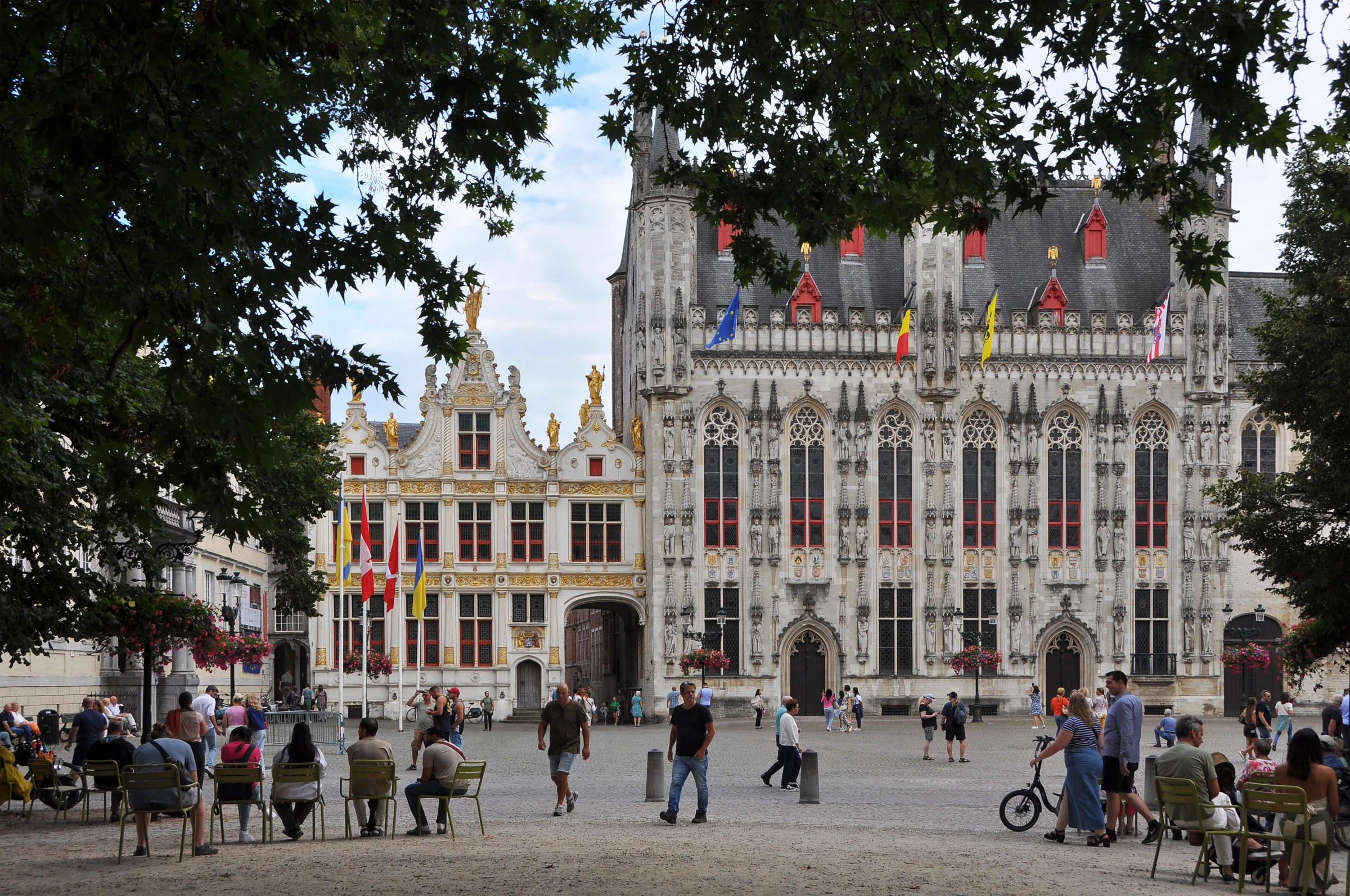
Begin with the broad space in front of City Hall. This is close to where a land route and the Reie met, making the site useful to the rulers who established a fortress here in the early Middle Ages. The Counts of Flanders subsequently made their home on the Burg. The fortress is part of the square’s history, while what you can examine most easily today is a row of buildings whose façades record several later ways of expressing authority.
The Gothic City Hall provides the largest field of stonework. Read it first from top to bottom. The tall windows break its surface into regular bays. Above and between them, narrow architectural frames make room for statues and ornament. The decorated wall stands directly on the public square, so a person looking up from its pavement can take in both the entrance and the sweep of the upper storeys. At the adjoining Civil Registry, attention shifts to a shorter, differently proportioned front with dark openings, a pale surface and gilt details.
Turn to the basilica tucked into the corner beside City Hall. From outside, much of its presence comes from the amount of sculpture and ornament concentrated around a relatively narrow entrance. Its lower chapel is Romanesque and dedicated to St Basil, while the upper one houses the relic of the Holy Blood. The exterior photograph cannot show the relationship between these two interiors. It can show how little frontage a building of considerable religious importance was given on this edge of the square.
Look in the opposite direction for another kind of evidence. St Donatian’s Cathedral once stood across from City Hall. The open ground on that side gives today’s square a different balance. Compare the spaces in these photographs with the broad, commercially oriented Markt. At the Burg, the main groups of buildings face an open space through which the city’s residents could approach different institutions within a short distance.
Real-travel note
Check City Hall and basilica visiting information separately, especially during worship or civic events.
Each photograph has its own camera position and capture date.
Chapter 3
Rozenhoedkaai, a view made at a bend
Start with the water in the wide photograph. The first thing to follow is the meeting of the water and the walls. One edge leads toward the houses, while another edge opens away into the curve of the canal. The bend gives the view its depth. The Belfry stands well behind the front row of buildings, yet the water and lower rooflines leave enough space around its upper section to bring it into the same composition. If you remember its appearance at the Markt, use that memory to separate the distant tower from the rooms, windows and roofs at the water’s edge.
The quay has had more than one name and use. Visit Bruges records the earlier name Zoutkaai, or Salt Quay, and associates the later name Rozenhoedkaai with stalls selling rosaries. Salt belonged to the business of storing and moving food, and rosaries to a different kind of trade. Both names help recover the quay as a working edge of the city. Its present fame as a viewpoint depends in part on the same basic arrangement that made the place useful: the approach from land meets a turn in the waterway.
The other two photographs shift the emphasis. The detail looks up from the water’s edge toward the row of stepped gables. Notice how a narrow wall and a white gable stand out against the blue sky. In the context view, people, flower baskets and terraces mark the top of the quay wall, giving the bank a sense of scale. Return to the wide frame to put those observations beside the canal bend and the Belfry. The three perspectives pick out separate parts of the same waterfront.
Stay with the edge of the canal as you go into the next chapter. Dijver uses a longer waterline and more space under trees. Together the two views explain why a place famous for its canals can have several quite different relationships to the water in the space of a few streets.
Real-travel note
Consult the official quay listing for visitor information if you plan to see the bend in person.
Each photograph has its own camera position and capture date.
Chapter 4
Dijver, a long bank beside the museums
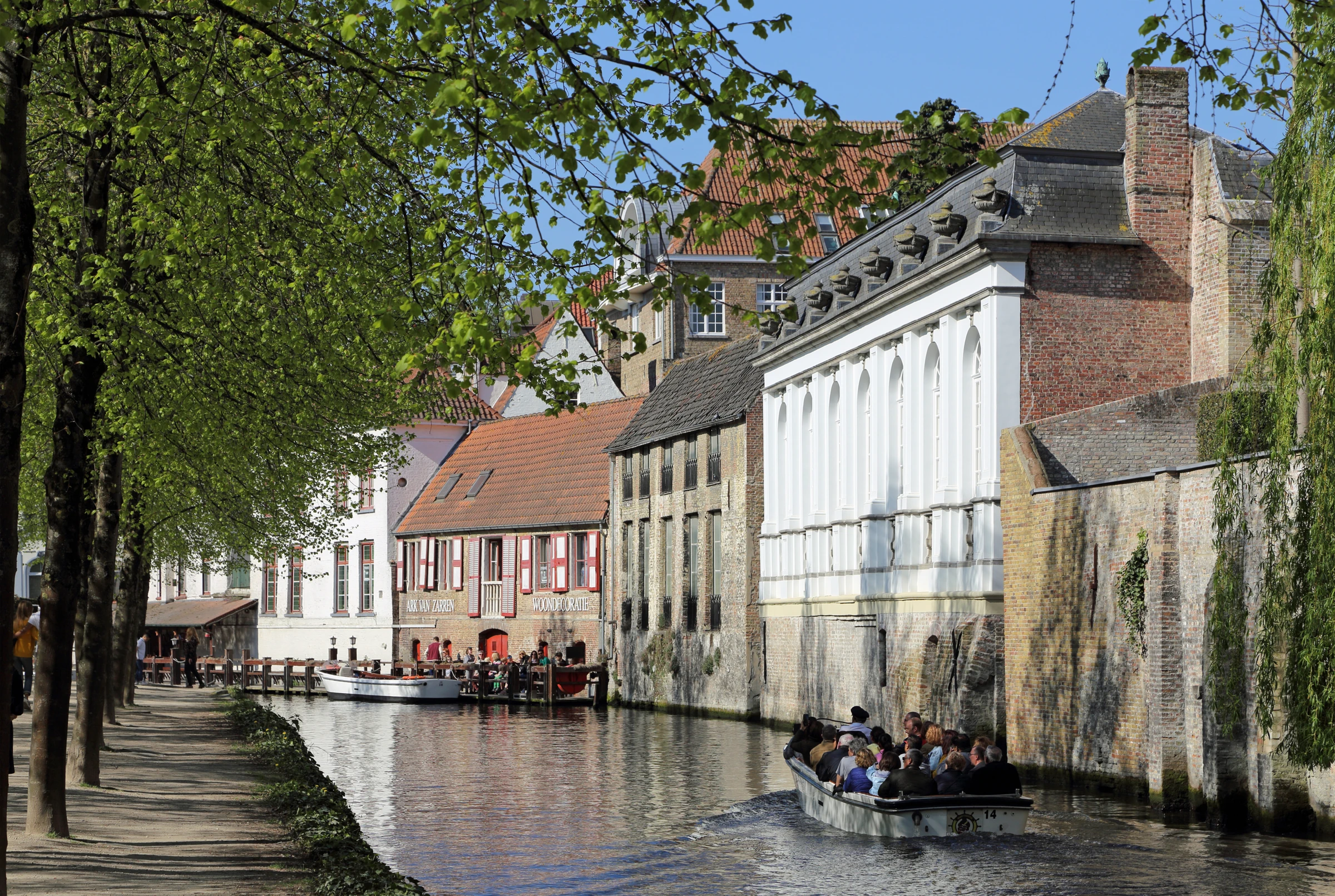
At Dijver, let your gaze travel the length of the bank. The bend at Rosary Quay gathered several features into one close view. Here a line of trees and an extended stretch of water keep pulling the eye sideways. Visit Bruges draws attention to the softer bank along part of Dijver, where the Reie keeps a less engineered appearance than beside high retaining walls. Look for changes in the edge as the water passes the greenery, a building or a bridge. The proportions of bank, path and water can tell you more about a particular stretch than the colour of the buildings.
The long reach also gives museums and domestic façades a shared setting. The Groeningemuseum on Dijver holds early Netherlandish paintings associated with the city’s artistic prominence. The nearby Gruuthusemuseum occupies a mansion that belonged to the Lords of Gruuthuse. Their physical proximity helps explain why it is possible to read the city’s wealth in collections, buildings and public spaces at the same time. The outdoor photographs are useful for locating walls, entrances and the length of the canal. The artworks themselves have their own conditions of display and visiting.
Compare the photographs by finding a firm horizontal reference in each. In an open view, the waterline can carry the composition. Beneath foliage, the same line can be partly covered by reflections, shadows or projecting branches. If the tower of the Church of Our Lady appears above a photograph’s roofs, follow its outline down until the nearer buildings hide it. That overlap separates the long canal view from the enclosed angle beside Boniface Bridge, where the water and buildings press into a much smaller space.
From here, the Church of Our Lady and Boniface Bridge make two separate discoveries. Carry the question of distance to both. The church tower works as a city landmark, while a bridge, a doorway or a short wall only makes sense when seen against the width of the water beneath it.
Real-travel note
Use Musea Brugge to plan individual museum visits and check current access.
Each photograph has its own camera position and capture date.
Chapter 5
Begijnhof, houses around a quiet green
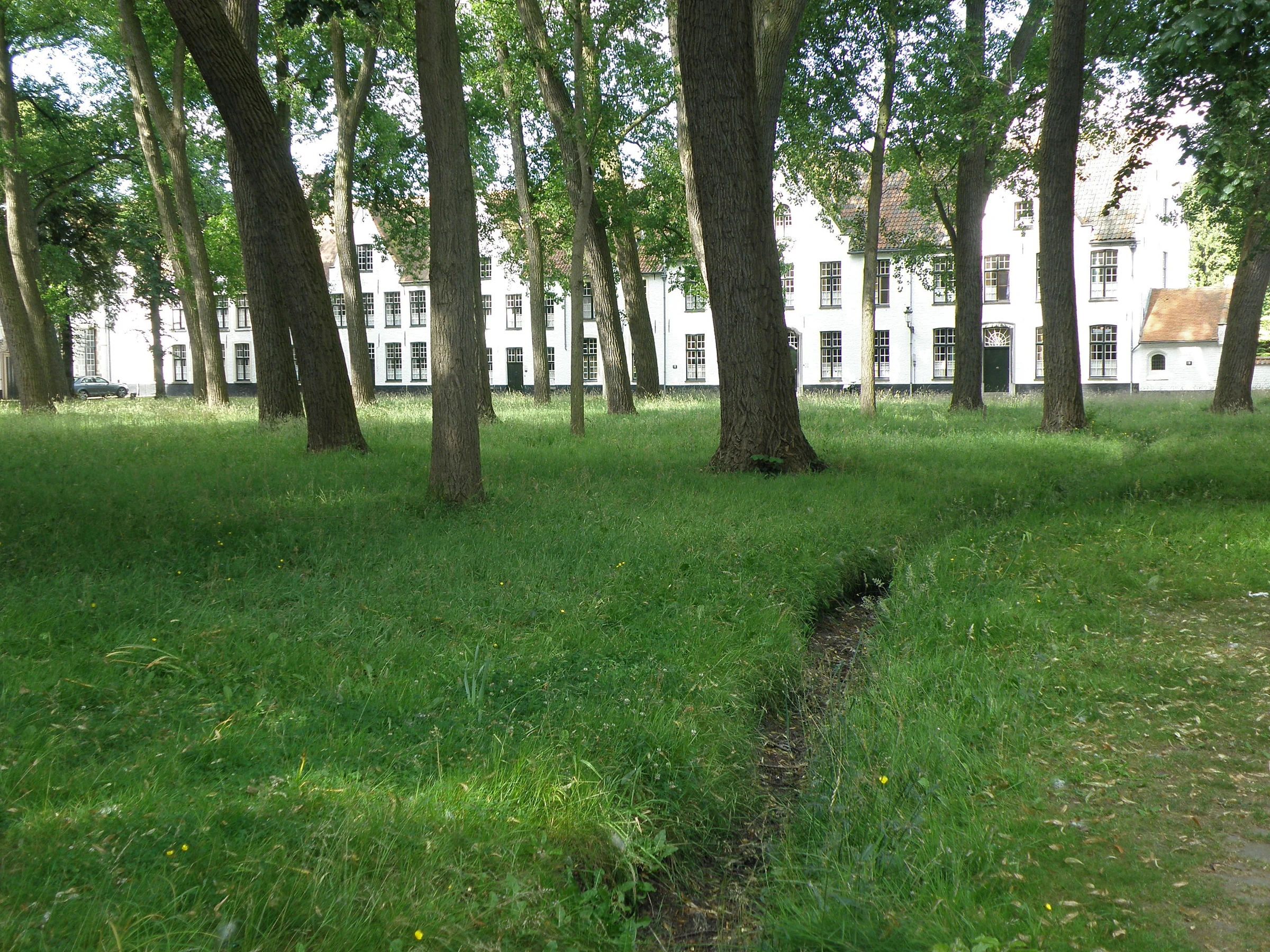
The three photographs of the Begijnhof look into the courtyard from within the enclosure. The open centre gives white houses, paths and trees enough separation to be seen individually. In the optional exterior 360° view, the entrance bridge and gateway give a separate sense of how the compound meets the water. Compare this open ground with the Markt. Both organise the movement of people around an empty middle, but the houses here are lower, their doors closer to ground level, and their fronts more directly related to the green.
The Princely Beguinage Ten Wijngaerde was founded in 1245. It belonged to a tradition in which beguines, women pursuing a religious life in community, could live within an organised settlement with its own houses and shared buildings. UNESCO lists the Bruges site with other surviving Flemish beguinages and describes the distinctive settlement type through the arrangement of dwellings, church, outbuildings and open spaces. The Bruges community changed over time and Benedictine sisters succeeded the beguines in the twentieth century. The age of the institution and the construction dates of individual buildings are separate questions.
Look across the courtyard from one house to the next. White walls provide a visual link, while roofs, windows, door positions and the spacing of trees divide the edge. Pick one doorway and judge how much distance the path and grass put between the photographer and its threshold. Use the wide view to take in the lawns and white houses, then compare the spring daffodils and the winter view of the chapel and cobbled path. These distinct positions reveal more of the courtyard. The exterior panorama offers a separate look at the gateway from the bridge.
The final discovery widens the frame at Minnewater. The Begijnhof has a long relationship with the water around it, but the view into the enclosure is inward and close, whereas the lake offers room for a much longer sightline. Together they end the journey with two very different kinds of open space.
Real-travel note
Consult the official Beguinage listing for gate hours and visitor etiquette.
9 reviewed experiences
Explore along the route
Step into the places along this journey. Choose a view independently of the story chapters. Free previews do not count toward chapter progress. Return to the journey above to continue through its stops.
Markt, the city’s trading square Short observation sequence
360° capture month 2019-05. 3 connected local positions with movement in either direction. Three views from the edge of Markt look across café terraces and stepped gables toward the Provincial Court. Still photograph taken 2010-06-28.
Reviewed 2026-11-19 · Nearby viewpoint
Explore at your own pace; these views do not count toward chapter completion. Check each point's coverage note before navigating provider imagery. Availability may change.
Sources
- History of Bruges — Visit Bruges
- Markt (Market Square) — Visit Bruges
- Markets in Bruges — Visit Bruges
- Belfort (Belfry) — Visit Bruges
- Historium Bruges and the former Water Hall — Visit Bruges
- Stadhuis (City Hall) — Visit Bruges
- Burg Square, Holy Blood Basilica and Dijver in the official visitor guide — Visit Bruges
- Rozenhoedkaai (Rosary Quay) — Visit Bruges
- Rosary Quay in the Visit Bruges City Film Office guide — Visit Bruges City Film Office
- Groeningemuseum — Musea Brugge
- Gruuthusemuseum — Musea Brugge
- Bonifaciusbrug (Boniface Bridge) — Visit Bruges
- O.L.V.-kerk Museum (Museum of the Church of Our Lady) — Visit Bruges
- Beguinage as a UNESCO World Heritage Site — Visit Bruges
- Begijnhof (Beguinage) — Visit Bruges
- Minnewater (Lake of Love) — Visit Bruges
- Historic Centre of Brugge — UNESCO World Heritage Centre
- Flemish Béguinages — UNESCO World Heritage Centre
- Bruges’ Markt with the Breydel and De Coninck monument in front of the stepped-gable houses on the north side — Marc Ryckaert ( MJJR )
- The bronze figures and carved stone base of the Breydel and De Coninck monument in the Markt — CEphoto, Uwe Aranas
- Flags, café terraces and façades lining Bruges’ Markt — Marc Ryckaert
- Burg Square from beneath the trees, with the Civic Registry and the Gothic Town Hall across the paving — Marc Ryckaert
- Carved arches and gilded figures on the Basilica of the Holy Blood at Burg Square — Daniel VILLAFRUELA
- The narrow brick walls of Blinde Ezelstraat leading towards a decorated arch by Burg Square — Marc Ryckaert
- Brick canal-side houses, a willow and the Belfry at the bend of the Rozenhoedkaai canal — Sally V
- Stepped gables and red window frames seen from water level at Rozenhoedkaai — DELAHJ
- Flower baskets and stepped-gable houses along the Rozenhoedkaai quay, seen across the canal — Marc Ryckaert
- Sightseeing boats pass brick and stone façades beside the tree-lined Dijver footpath — Marc Ryckaert
- The stone gateway to the Groeningemuseum on Dijver, with an arched entrance and wall lanterns — Navy8300
- A tree-lined stretch of Dijver with pale façades and flags along the street — Marc Ryckaert
- A lawn shaded by tall trees, with white houses beyond, in the Bruges Begijnhof courtyard — Torsade de Pointes
- Yellow daffodils and a paved path among the trees in the Begijnhof courtyard — Ermell
- Whitewashed houses and a chapel along a cobbled path in the Bruges Begijnhof — Lerichard
- The Belfry rising behind gabled buildings at the edge of a paved square in central Bruges — CEphoto, Uwe Aranas
- The stone arch of St Boniface Bridge over the canal beside an old brick building — Fernando Losada Rodríguez
- The brick spire and upper walls of the Church of Our Lady seen through green leaves — TMart
- Trees and Kasteel de la Faille reflected in the water at Minnewater — Sally V


Your journey, remembered.
Explored 0 of 5 stops. Explore every stop to unlock your keepsake.
5 stops to your keepsakeExplore every stop to share or download your keepsake.
Plan your Bruges visits
Use the five chapters to get oriented and consult each site for visiting arrangements.
Official sources checked:
Chapter order
The chapters follow the Markt, Burg, Rosary Quay, Dijver and the Beguinage.
Visiting information
Check opening hours, tickets and accessibility for each visit.